
The stretch of the Pacific Coast Highway north of Nacimiento Road holds some of the highway’s most interesting attractions. The first one is Big Creek Bridge, one of several historic concrete arch bridges along Highway 1. This double-arch bridge was completed in 1937, and received a seismic retrofit in 1999, so it should hold up for quite some time to come.
On my drive up the California coast in 2004, the Big Creek Bridge was one of the last places I was able to photograph, before sunset. I had poorly estimated the time it would take to drive the PCH, and it didn’t help that I had started too far south (in Santa Barbara). On this trip, I was determined not to make the same mistakes, and as you can see, this time, I had arrived much earlier.
McWay Falls, Julia Pfeiffer Burns State Park

Adding to my disappointment on that 2004 vacation, the premature sunset forced me to drive past one of the most beautiful spots on the Pacific Coast Highway. That time, as I drove past McWay Falls at Julia Pfeiffer Burns State Park, I actually considered coming back the next day. Of course, driving back down the coast from Monterey would have wasted far too much time, so eventually I abandoned the idea.
McWay Falls is an 80-foot waterfall that plunges gracefully into the Pacific Ocean, inside a cove, next to an inaccessible beach. The waterfall runs year-round…

… so you can stop by anytime, and find this postcard picture waiting for you.
“Vista Point”

Further up the road, I stopped at another location marked “Vista Point”. Of course, there are a thousand good viewpoints on the Pacific Coast Highway, but since this one was given its own sign, and an actual paved parking area, I figured it was more worthy of a stop. As you can see, it’s one of the best places for viewing the coast towards the south.

It seemed like a good place to sit and relax for a moment.
A little further up the road…

… I stopped at another turnout…

… and found yet another great view of the coast, looking south.
North of this point, Highway 1 curves inland for a short while, as it passes through the community of Big Sur. If you need to buy some expensive gas, this is a good place to get some. Otherwise, continue north.
About 25 minutes after taking the previous picture…
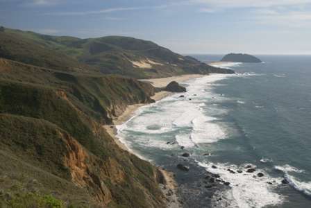
… I had just driven by Point Sur Lighthouse, when I found this viewpoint. The lighthouse is located on that “island” in the distance. It’s not quite an island, since it’s connected, just barely, to the mainland. The lighthouse is protected as part of Point Sur State Historic Park, and guided walking tours are available. (Check out the tour schedule here8.)


No comments