
After visiting the Trinity Site, my primary goal for the day, I suddenly realized that I needed to figure out what to do, and where to go, next. My admittedly poor planning led to several frustrating hours of driving around central New Mexico. I chose to head towards the mountains around Ruidoso, hoping for some nice pine-scented scenery.

Just a few miles outside Carrizozo, you’ll pass the black lava fields of the Valley of Fires Recreation Area. There’s a roadside turnout that allows you to climb around on the volcanic rock. If you want to extend your stay, the official state recreation area offers bathrooms and picnic shelters (but you’ll be required to pay a day-use fee).
While driving towards Ruidoso, I saw a sign promising “Bonito Lake”, just 4 miles away. “Bonito” means “pretty”, so I thought it sounded like a good side trip. After 4 painfully slow miles up a 1-lane forest road, I found this:

… a small, manmade lake with a mostly dry lakebed. Perhaps under different conditions this patch of water deserves the “pretty” title, but not this day. After struggling to find a parking spot (the lake is popular with fishermen), I snapped a couple of pictures as proof that I’d been there, then made a u-turn.
With Bonito Lake somewhat of a bust, I returned to Rte. 37 and continued towards Ruidoso. It’s a picturesque mountain town filled with condos and resorts, but very little worth photographing. If you lived in New Mexico and needed a break from the desert, it might be a nice place to spend a few days. But for my road-tripping purposes, it offered very little.
A few miles north of the Rte. 37 intersection, and once you’ve left behind most signs of civilization, you’ll come across the only other place I found worthy of a photo.

This roadside turn-off provides a view of the sometimes snow-capped mountains above Ruidoso and the surrounding towns. While Sierra Blanca tops out at 11,973 feet, it’s rather small from this distance. It’s unfortunate that I couldn’t find a single place in town to view them, without a condominium complex in the way.

The next town you’ll reach is Capitan, which is home to the Territorial Theatre, a building which I know nothing about, but I thought it looked photo-worthy.
You’ll also find the Smokey Bear State Historical Park at the downtown crossroads in Capitan, which is home to the final resting place of the famous fire-singed bear cub, Smokey Bear. If seeing the bear’s grave is worth the $2 admission fee, then stop by.

Back in Carrizozo, consider playing a very hot and not-so-very green game of golf at the public course.
Claunch, New Mexico
There’s not a lot along New Mexico Rte. 55. The land is flat to gently rolling, and very dry, with just an occasional tree. Any mountains are far in the distance, and chances are, so is the nearest car. Enjoy the tranquility of desert driving for about 20 minutes before reaching the don’t-blink-or-you’ll-miss-it town of Claunch, New Mexico.

Claunch has a main street…

… a couple of farm houses (this one also serves as the post office and library)…
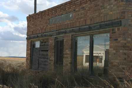

… an old, boarded-up dry goods store…

… a church…

…and the shell of an old building, which used to be the “Claunch School”. It’s behind a fence now, so I couldn’t explore.

Note: This trip was first published in 2006.


No comments