Location
Maryhill, Washington’s Stonehenge war memorial is located on Washington Hwy. 14, directly above the Columbia River. If you’re coming from Oregon, you’ll need to cross at US 97 (the Sam Hill Memorial Bridge, which is due for improvements starting in 2007 – check with WSDOT for info). The turnoff to Stonehenge is well marked, although it feels like you’re driving away from everything before you get there. Here’s a Google Maps aerial picture, to lend some perspective. Do not follow signs for the Maryhill Museum (unless you want to go there too), since it is in a different location, about a mile away from the Stonehenge replica.
My Visit

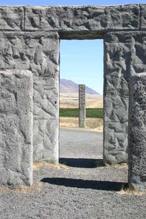
This replica of Stonehenge, which I will refer to as simply “Stonehenge” for simplicity’s sake, is officially a memorial to World War I soldiers and sailors. I have the feeling, though, that Samuel Hill really just wanted to build something big, and kinda cool, out of concrete.

He succeeded. The reinforced concrete walls of this Stonehenge provide a good idea of what the original rocks would have looked like, if they hadn’t crumbled over time.


This plaque explains the reason all this is here–to honor the 13 Klickitat County servicemen who died in World War I. I like what it says:
“This monument is erected in the hope that others inspired by the example of their valor and their heroism may share in that love of liberty and burn with that fire of patriotism which death alone can quench.”
The names of the 13 men appear in smaller plaques, affixed to the stone pillars.

From Stonehenge’s fantastic location, you can enjoy a great view of the Columbia River, a small patch of green farmland, the Sam Hill Memorial Bridge, and…

… of course, Mt. Hood, which is growing farther away, as you head east.
As you leave Maryhill, headed east, you face a long stretch of nothingness. Rte. 14 stays along the Columbia River almost the entire way to Interstate 82 and US 395 (which will take us north towards Pasco/Kennewick, then eventually Spokane). You may have to drive about 10 miles per hour slower than on the interstate, but the views and the solitude are worth it. While I-84 stays low along the river’s edge, Rte. 14 follows the topography of the land, climbing up and dropping down several times.
Note: This trip was first published in 2006. Much of the same area was covered in the Big Sky trip in 2014.


No comments