
It’s easy to feel lonely in Wyoming. You don’t even have to go to any big effort. The state is so big, and so empty, the odds are pretty good that at any given moment, you’re going to have whatever spot you’re in, to yourself. But you haven’t truly experienced lonely, until you’ve ventured a dozen miles away from the nearest paved road, in an economy rental car, only to find that you’re on a road meant for jeeps. Yes, it is at this moment that you truly experience the thrill (some people — the more normal among us — might call it fear) of being all alone.
I experienced the greatest “thrill” of my vacation on the Red Gulch/Alkali Back Country Byway, a road which I really shouldn’t have been on, yet, I’m immensely glad I traveled.

On the west side of Ten Sleep, Wyoming, I turned off of US 16. For a few more miles, I still had pavement beneath the tires of my economy-class rental car. I was on my way to Hyattville, a very tiny town. I think its biggest claim to fame is achieving the status of a Census Designated Place.
The road I was on, wasn’t really the right road. There is a dirt road that runs from downtown Ten Sleep directly to Hyattville. I had missed that turn, so instead, I took Tensleep Manderson Road, then cut over to the correct dirt road.
The Back Country Byway didn’t technically begin until Hyattville, but the road was already incredibly scenic.

The pavement passed through green patches of farmland, squeezed in between occasional red-dirt hills. It’s a great road — the kind of road that puts you at peace, and the kind you could drive forever, without ever tiring of the scenery.

After about 7 or 8 miles, I found an unmarked road that turned off to the right. Even though I was guessing, the gravel and dirt road turned out to be the right one. It continued the journey through this remarkable scenery…

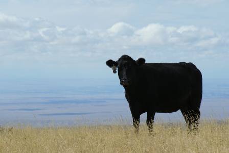
… and past some incredibly colorful hills. This was cattle grazing land, and the cattle were the only signs of life around. I stopped my car in the middle of the road, left the door open and the motor running, and climbed up a small hillside to take this picture. I wasn’t the least bit worried that someone else would drive by. At this point, the solitude was my friend.

The town of Hyattville welcomed me with a sign, placed by the local 4-H club. I was amazed that they had enough visitors to be worth welcoming.

Downtown Hyattville has one cafe, a post office…

… and a few houses. The pavement had resumed at the edge of town, but it wouldn’t stick around for long.

On the north end of Hyattville, the paved road, Route 31, curved to the left. The road I was looking for was straight ahead: the Red Gulch/Alkali Back Country Byway. A weathered sign marked the official start of the byway.

Just beyond the sign, I found an excuse to wander onto someone’s property. An old, partially-collapsed log house stood alone on the prairie, with the Big Horn Mountains in the background. Awesome.

Not far away, an old metal cow-feeding thing (forgive me, I’m a city boy) was slowly rusting.

Up the road a short way, the byway designers had gone to the effort to make a turnout — a dirt road that split off from the other dirt road, and led to the top of a small hill. Here, a faded old sign advertised the scenic road ahead.
The only words I chose to ignore were “high clearance”. Up to this point, and for several miles that followed, the surface was nice and smooth, and I had no trouble driving at a reasonable speed. I just figured they were being overly-cautious with their advisory. I’d be fine.

The landscaped continued to be extraordinary. The road passed by more red hills…

… before dropping down into a wide valley…

… that stretched out for miles on either side of the road. It was all beautiful, and it was all mine. There wasn’t another person anywhere nearby.

Eventually the road climbs out of the valley. It gains quite a bit of elevation — the bottom of the valley is around 5,000 feet, but after just a few miles, the road tops out above 7,000 feet.

After the dramatic climb out of the valley, the road continues climbing, but now it’s passing through some flatter land…
… that’s occupied by a few cattle. Notice behind the bull: that’s the 100-mile-wide Bighorn Basin, which separates the Big Horn Range from the rest of the Rocky Mountains.
It was around this point, 11 miles out from Hyattville, that the road started to get a little rougher. Actually, a lot rougher. There were rocks everywhere, jutting out of the road surface, and I was creeping along at 10 miles per hour, tops. But I had come so far, already! There was no way I was turning around now. If it doesn’t get any worse, I’ll be fine.

As I rolled slowly along, about 14 miles out of Hyattville, I came upon a road sign. The options: Alkali Road, straight; Red Gulch Road, left; Back Country Byway, left; US Highway 14, left 20 miles. This left me a bit confused. I expected to continue north, all the way to US 14, but according to the sign, the route that led to US 14 turned left, along with the byway. I was fairly certain that Alkali Road, the road I had been following, would also connect with the highway — but it had already become so rough! If the byway turns, Alkali Road will likely get worse, I reasoned. I should stick with the byway. I reset the odometer. It’s only 20 miles. I’ll be fine.

Except for one thing. This is the turnoff. The byway switches from a nice, wide (but admittedly bumpy) dirt road to a narrow two-rut track, that’s even rougher than Alkali Road. Could my little car handle a road like this? That sign, back at the beginning, said “high clearance” two wheel drive. I looked at my gas gauge, and realized I was lower on fuel than I had hoped. Darn those high gas prices in Buffalo! I should have topped off. Continuing up Alkali Road might not just waste my time, it could also burn off too much fuel. I needed to take the sure route. So, with a quick prayer, I took the turn.

Of course, the horrible road continued to be extraordinarily scenic. Notice the antelope crossing the street ahead of me.

Red Gulch Road stayed near the edge of some very great drop-offs, but far enough away to remain safe. It also passed by hills like this one, marked with carins (piles of rock) to help early ranchers know their property boundaries.
About 21 miles out of Hyattville, and about 7 miles from the turnoff, the road smoothed out a bit. It remained narrow, but now, instead of jolting rocks, my biggest concern became patches of loose dirt, so thick I thought I might get stuck.

At one moment, a small valley opened to the left side of the car. Beyond it was the Bighorn Basin.

There were occasional fences out here.

About 22 miles out of Hyattville, the view changed dramatically. The Big Horn Mountains appeared on the horizon…

… along with more of those familiar red hills. Look closely, and you can see the road at least two miles ahead, as it climbs up and over the hills.

I kept clicking off the miles, slowly and steadily. I expected more nothingness, all the way to US 14, but I was suddenly surprised by a parking lot, picnic tables, and other people! I’ll finish up the byway, and tell you about this surprising prehistoric attraction, on the next page.
Note: This trip was first published in 2008.


No comments