
This is, of course, the Beartooth Highway’s claim to fame. The famous road-tripping journalist granted the Beartooth the highest honor which a road could receive, and I wasn’t about to question his judgment. So, I planned my trip around driving the Beartooth. The only thing I couldn’t plan, was the weather, and sadly, it was taking away much of the road’s promised beauty.

It had rained on me ever since I left Billings. The hour-long drive was quite gloomy and boring, and I spent most of the time searching the sky for any potential break in the thick clouds that hung overhead. I found none.
When I reached the town of Red Lodge, I figured there was no reason to hurry. If I killed some time, perhaps the weather would pass. So, I walked through Red Lodge’s main business district along Broadway Avenue.

This is a great tourist town — not over the top, but still providing all the essentials: restaurants, motels, and souvenir shops. It was cold, though, perhaps around 50 degrees or so. Red Lodge is at 5,568 feet, while Beartooth Pass tops out at 10,947 feet — a full vertical mile higher. As I prepared to leave town, I wondered, would I be driving through rain or snow?

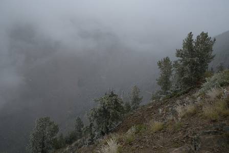
As I began the climb up to Beartooth Pass, I realized I was about to drive America’s most beautiful road, without seeing anything at all. The dramatic scenery begins just after leaving Red Lodge, but I couldn’t see the tops of the huge hills that rose on either side of the highway. Before long…

… I was in the middle of those clouds. The first switchback came just below 8,000 feet. Beyond the big curve was a deep, narrow valley. I bet it would be stunning, on another day.

Hey look! You can almost see some mountain peaks!

Even though I knew I was missing a lot, I was still having fun. I like the challenge of driving through bad weather, and as I watched my car’s on-board thermometer drop into the 30’s, I knew snow was waiting, just ahead. But how much? Would I be in a blizzard by the time I reached the pass?
Rock Creek Vista Point

On another sharp curve, at 9,190 feet, road builders managed to find enough room for a small parking lot, then constructed a short trail that leads out a narrow ridge to a viewpoint. On one side lies Rock Creek, and on the other, Wyoming Creek.
At the viewpoint, I could (just barely) see one of the creeks below, as a break in the clouds drifted by.

Some happy chipmunks live here, seemingly oblivious to the cold.
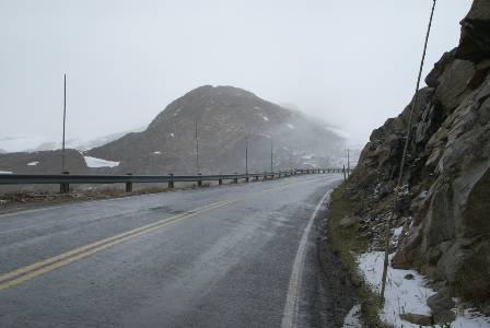
As the road made its way higher, the drizzle eventually did turn to snow.

After climbing above, 10,000 feet, the road leaves Montana and enters Wyoming. It will re-enter Montana briefly, just before entering Yellowstone National Park.

The alpine lakes along the Beartooth Highway are the jewels that make the route so spectacular. One such lake is Gardner Lake, a long, narrow lake that’s in a canyon about 600 feet below the road. There is a steep, 3/4 mile trail that leads down to the lake (and another lake, about 2 1/4 miles further). For about half a second I thought about hiking down there, but then I realized I was standing in ankle-deep snow, with more falling all around me.

So, I had to be happy with sorta being able to see it from the road.

I reached Beartooth Pass in the middle of a near-whiteout. Besides a sign and the road, I can’t tell you what else there is to see there. All I knew for sure was that I had topped out at 10,947 feet…

… and the temperature was 25 degrees. Beyond the pass…
The road slipped through more narrow passages…

… and came close to several more lakes. These were more accessible than the previous ones, and the snow had slowed a bit.

Since this lake was so close by, I walked down to the edge and explored a bit. A nice blue reflection sure would have been beautiful in that water.

At Hauser Lake Trailhead (the lake is 3/4 mile away, in the direction opposite of this picture), the clouds had broken enough to give me a slight view of some of the mountains I had missed.

A bit further, a long lake paralleled the road.

In the distance, on the south side of the road, the Chain Lakes stretched out.

There is just one business along the entire Beartooth Highway, and it’s almost mandatory that you buy a souvenir there. The tiny Top Of The World Store is absolutely packed with everything you could imagine — including food and other necessities. You’ll need to take at least 10 minutes to wander around the store several times, just to see it all. The Top Of The World Store also sells gasoline, and has four modestly priced motel rooms.

Beyond the Top Of The World, I found more lakes…

… more curves…

… and more views of mountains, many of which were still hiding behind clouds.

I still couldn’t see much at the Pilot Index Overlook…

… but by the time I reached the Clarks Fork Overlook, some blue sky appeared!
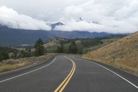
Just a short distance further, I could see just a bit more of Pilot and Index Peaks, but the clouds were still spoiling the show.
15 minutes later…

… I was back in Montana, and closing in on Cooke City. The skies were more promising, and for a while I considered turning around, and re-driving the Beartooth, in hopes that the weather behind me would have also cleared. Such a detour would have taken too much time, though, so I moved on…

… across Colter Pass and into…
Cooke City, Montana

Cooke City is a funky little western town, cut off from the rest of Montana by the mountains. Its main industry is tourism, which is no surprise, considering it’s just a few miles away from Yellowstone National Park.

If you didn’t get enough souvenirs already, visit the Cooke City Store (established 1886). There are other gift shops in town…

… as well as a few restaurants, motels (a Super 8 and several independently-owned inns), and Hoosier’s Bar.
Silver Gate

A few miles beyond Cooke City, and just before the northeastern entrance to Yellowstone, is the community of Silver Gate. There are just a few businesses here — most of the activity is up the road in Cooke City.
Note: This trip was first published in 2008.


No comments