
After spending several hours in the Bisti Wilderness in northeastern New Mexico, I only had one other goal for Day 4: to spend the night at the Wigwam Motel in Holbrook, Arizona. Since it was only mid-afternoon when I arrived back at Interstate 40, I decided it was too soon to head immediately to the teepees. I quickly formulated another plan: drive to Grants, then take a scenic loop through El Malpais and El Morro National Monuments, before reconnecting with I-40 at Gallup. It would definitely kill the time, but I had no idea what I’d actually see.
It’s worthwhile to spend a few minutes driving through Grants, if only to see the small section of old US Route 66 that remains here. Along the way, you’ll spot some nice neon from the road’s heyday…

… like the sign for the Grants Cafe.

Breakfast burritos (no doubt stuffed with green chile) are a big hit, but apparently…

… so is booze. The Handy Andy remains open…

… while the Roarin’ 20’s has certainly seen better decades.
Admire the neon, and maybe stop in at a Route 66 gift shop, then head on down the road.
As you drive along Rte. 53, you first pass through El Malpais National Monument. As the name implies (Malpais meaning “bad land”), the park service protects a large section of land covered by volcanic flows, some formed as recently as 3,000 years ago. None of them can be seen from the road. I stopped at one trailhead, but discovered it would be a long hike to see anything exciting, and even then, it would only be volcanic rock, which I had seen in other places. I kept going.
I chose to drive by for a few reasons: 1) I was already cold, and seeing more ice didn’t exactly thrill me, 2) I wanted to see El Morro before dark, and 3) I was a little miffed that even with an annual National Parks pass, I’d have to pay to see a private attraction inside a National Monument. But mainly, I was cold.
Click here if you want to check out their website.
Up until arriving at El Morro National Monument, the drive was easy, the road was smooth, but the scenery wasn’t terribly exciting — just some hills and a lot of trees.
El Morro National Monument
El Morro National Monument was the one highlight on my scenic drive. This rocky outcropping has been a stopping place for tourists, even hundreds of years before the automobile. A protected pool of water, available year-round, made this a popular stop.
It was also here at El Morro that I experienced one of those purely-by-coincidence road-trip moments. As it turned out, I was visiting on an auspicious occasion: the exact (to the day) 100th anniversary of the proclamation making El Morro a National Monument.
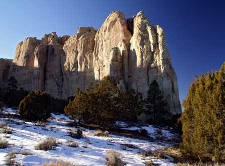
From a distance, El Morro is pretty impressive. There are two trails that also allow you to experience it, close-up. The shorter of the two is 1/2 mile in length, and allows you to see the pool and many of the inscriptions, left by early explorers and travelers. The longer trail is 2 miles, and takes you to the top of the rock, where you’ll find the ruins of an ancient (700+ years old) Puebloan community.
Since it was cold, and I had arrived late in the day, I chose the shorter trail.

The short trail doesn’t take long, and it gets right to the interesting parts of El Morro. First, you wind your way down to the pool…

… that sits below a seasonal waterfall. It is here that the ancient Puebloans and later explorers found refreshment.

Walk a little further and you’ll find some of the petroglyphs carved into the soft sandstone rock, hundreds of years ago.

Right next to them, you’ll see some historical graffiti, inscribed on the rock between the 1600’s and roughly 1900. The one pictured above is the oldest and most historically significant. The first governor of New Mexico, Don Juan de Oñate, inscribed his name here in 1605, along with the message (translated):
Passed by here the Governor Don Juan de Oñate, from the discovery of the Sea of the South on the 16th of April, 1605.
Oñate had just returned from the Gulf of California. This was at least his third visit to El Morro.
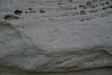
There are probably hundreds of names carved into the rock, some done with tombstone-quality precision (such as Gilmer Breckinridge’s name above), and others somewhat sloppily done (like Mr. Morrow’s).
Before you arrive back at the visitor’s center, the trail splits. The longer path leads to the top of the hill, passing even more inscriptions along the way. I hiked a short distance up this part of the trail, but not very far. It was miserable, thanks to the cold air, the howling wind, and the fact that this must be the east side of the mountain (and being so late in the day, there was no sunlight to provide warmth — it was at least 20o colder here than on the other side!).
Once finished at El Morro, drive on down Rte. 53.
Gallup, New Mexico
I arrived in Gallup just in time for the sunset. I grabbed a reasonably good dinner at El Sombrero Restaurant (it’s hard to go wrong when you smother everything in green chile), then checked out more of the old neon and funky motels along this stretch of old US Route 66.

The Ranchito was indeed quiet… almost too quiet…

… while the Desert Skies had one of the more impressive neon signs in town. This sign was huge, but unfortunately, wasn’t well maintained. I cropped out the gigantic ALL ROOMS 19.99 banner at the top. Most of these old motels offer similar prices, and you definitely get what you pay for. Wait, I take that back. I don’t think you even get that much. I’m pretty sure parts of the Desert Skies should have been condemned, as well as a few other dives along this strip.
There are good, fairly new hotels and inns along route 66, but overall Gallup isn’t the appealing old road town I had hoped for. It didn’t matter. I had a teepee with my name on it, just 90 minutes down the road, in Holbrook.
Note: This trip was first published in 2006.


No comments