
After leaving Merced, California Route 140 departs from the Central Valley, and heads towards the Sierra Nevada Mountains. It’s always fun to drive along and see snow-capped peaks looming ahead of you, behind foothills and flat ranch land. Highway 140 passes through them all, one step at a time.

The town of Mariposa is the last sign of civilization you’ll see for a while, so take a minute to walk up and down the sidewalks, poke your head into a shop or two, and enjoy yourself.
Downtown Mariposa is located on Highway 140 (and Highway 49 — the two run together through the business district).

The Mariposa County Courthouse is just one of many historic buildings in town. Built in 1854, it’s the oldest courthouse in California that’s still in use. It’s not on the main road, though — watch for signs.

Not long after leaving Mariposa, Highway 140 enters a valley, and never comes out. The road meets up with the Merced River (the river that flows out of Yosemite Valley, fed by all those waterfalls), then runs alongside the river for many miles.

It’s a beautiful drive, that slowly sinks deeper and deeper in between imposing mountains. For a while, those hills are green, then they become increasingly bare, exposing their rocky cores.
As I traveled along Highway 140, I was puzzled by the seemingly abandoned road on the opposite side of the Merced River. I wondered if it was an old highway, or a railroad right-of-way. There were no bridges connecting the sides, or providing access, so I figured it must no longer be used. But then, I spotted a few houses on that side of the river. I have no idea if anyone still lives there, and if they do, how they get to their homes.
Further on, a rockslide had blocked Highway 140. Temporary one-lane bridges had been set up to take the road across the river, and for a short while, the highway was a one lane, one way road (with the traffic flow controlled by traffic lights) on the opposite riverbank. I figured this was a temporary fix, until I noticed the detour appears on Google Maps8. Either way, I was happy to get to drive, just for a moment, on that mysterious abandoned road.

Just after entering Yosemite National Park, the entrance road squeezes between two huge rocks…

… then continues to run alongside the Merced River. There are numerous turnouts along the road, allowing you to stop and take pictures of the dozens of tiny waterfalls that form as the river tumbles downhill. The temptation to stop and gawk is great, but this scenery pales in comparison to what’s just a few more miles up the road.
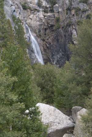
At one of those turnouts, I found a small waterfall. There were no signs pointing to it, and it wasn’t marked on the park map. Waterfalls are so common here, discovering one is no big deal.
Drivelapse Video
Here’s the time-lapse, dash-cam video of the drive from Mariposa into Yosemite National Park:


No comments