
At Sparwood, I only had a couple of options: I could either keep driving west on the Crowsnest Highway (a path I’d be covering again, two days later), or I could head north on BC Highway 43 — essentially a dead-end road, that leads to the town of Elkford. Without knowing much about what I would find, I headed north.

Highway 43 is a beautiful road. Over the course of 35 kilometers (22 miles), it passes through the Elk Valley, with Rocky Mountain peaks poking up on either side of the road, and at times, right in front of you. The road has only been around (as a paved highway, at least) since the mid 1980’s — just a few years after Elkford was developed as a temporary housing community for coal mine workers.

Along the side of the Elk Valley Highway, keep an eye out for some friendly horses. They were eager to meet me at the fence line…

… and show off a little for the cameras.

Okay, show off a lot.
Continuing on up the road, you’ll soon arrive in Elkford.

Not only is the town relatively new, it’s still pretty small. There isn’t much in the way of shopping or restaurants, but I’d expect that to change. Given its remote location, it’s becoming popular with tourists who want to explore deep in the Rockies.

There’s only one big intersection in Elkford, and it’s regulated by a flashing red light. Make a right, and you’re on Fording Road, and you’ll immediately cross the Elk River. Stop on the far side of the bridge and walk back, for a nice photo of Wapiti Mountain (elevation 2,495 meters/8,185 feet).

On the far side of the bridge, you’ll find a parking area that appears to be popular with snowmobilers in winter. Plenty of snow was left untouched, thankfully.

Drive a short distance further up Fording Road, and watch for a side road that leads to a scenic viewpoint. Here, you can picnic while looking over the Elk Valley, and Elkford.

Click on the image for a larger version.

Drive a bit further, and you’ll pass by (and underneath) some of the operations of the area’s coal mines. This brief industrial area is the only hint that something much bigger is happening nearby. Those buildings are the southern tail of a huge strip-mining area. Fortunately, the ugly scars are hidden from the view of most tourists — but you can get a look at them on satellite images.
I kept driving on Fording Road, until I reached its namesake river.

At the Fording River Bridge, I got out and took a few pictures…
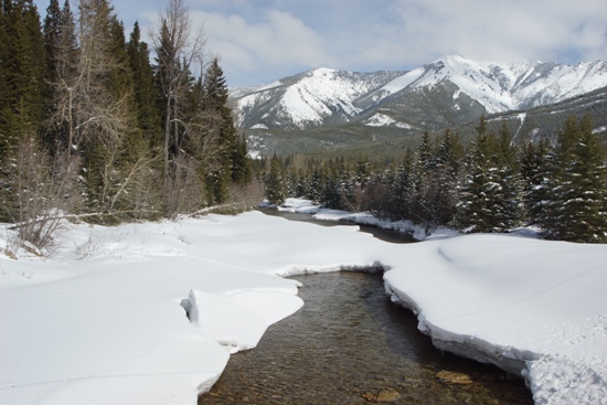
… of a mostly snowy landscape. Fording Road continues through the valley, past the base of those mountains, for a few more kilometers. It eventually ends in the middle of that huge surface coal mine. Since I didn’t drive any further out Fording Road, I can’t tell you how much you’ll see at the end of it.
Drivelapse Video
Here’s the time-lapse, dash-cam video of the drive from Elkford, back to Sparwood, then into Alberta, ending at Beauvais Lake Park:


No comments