
You can try to experience Big Bend National Park on foot, or behind the wheel of a car as you drive across its great expanse. But to really understand the park, and the region, you need to travel upon the river itself — the Rio Grande, that often talked about stream of muddy water that defines part of America’s southern border. Also, it’s a fun way to see part of the park, and part of Mexico, that you can’t visit any other way.
I booked my trip with Desert Sports, one of several river companies based around Terlingua. I made the reservation several weeks in advance, too early for them to predict which river trip I’d be taking. It would all depend on the water level. If more water was released upstream, we might need to take a raft trip through Santa Elena Canyon. If the flow was medium, we’d tackle Colorado Canyon. But my secret hope was that water levels would be low, so that we could canoe upstream, into Santa Elena Canyon, have lunch, then float back downstream. I was fortunate enough to get the exact trip I had wanted.

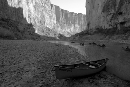
The day began at sunrise, at Desert Sports’ headquarters, which was conveniently located about a half-mile from my motel room at El Dorado Hotel, in Terlingua Ghost Town. Our group had about a dozen people, including two guides, Rebecca and Bobsky. After checking in and signing the appropriate paperwork…

… they gave us a water bottle (ours to keep), along with a dry bag and an ammo box. The bag was for snacks, sunscreen, and a change of clothes (just in case we needed it). The box was for my camera.
I’ll be the first to admit, the first hour of our adventure wasn’t very fun. We had to get to the river, specifically, the mouth of Santa Elena Canyon — a good, long drive from Terlingua. It’s the same place I had driven the previous night, not knowing I’d be returning 14 hours later.
An hour on a 16-passenger bus, on curvy roads, isn’t fun. Fortunately I grabbed a seat in the front row.

Upon arrival, we all grabbed canoes and supplies, and hauled the equipment down to the put-in spot at the mouth of the canyon.

After a bit of organization, and after getting fitted with flotation vests, Rebecca delivered a briefing on safety concerns. Her speech had very little to do with canoeing, and mostly focused on the biggest danger on the shore (rattlesnakes), and the proper way to… um… relieve yourself while in the canyon. The rule, it seems, is to urinate directly into the water, so that the canyon could instantly flush itself.

My canoe-mate was Ned from Dallas. That’s him, carrying the front of our canoe. He was keeping a close eye on his teenage son and stepson…

… who were teamed up in another canoe. Ned hoped they wouldn’t be miserable, for partially selfish reasons – he would like to do this again, and he knew if they hated this adventure, another one would be far less likely.

As we headed upstream, we enjoyed one of the most beautiful sights in Big Bend National Park. Canyon walls, a third of a mile tall, loomed over us. With each turn in the river, a new scene appeared. Shadows gave way to intense rays of sun, which set the rocky walls ablaze with color.

One twist in the canyon revealed a giant cliff-side cave, hundreds of feet above us. Another revealed sandbars and beaches.

The journey wasn’t easy. We had to do quite a bit of rowing, even though the current was weak. We also had to hop out of our canoe several times and carry it over rocks and sand, in areas where the water was too shallow. My Mizunos would never be quite the same, but I was due for a new pair, anyhow.
The reward for all that work came at lunchtime. Our group went ashore on a sandy beach, a few miles from our starting point (see the first picture on this page).

Bobsky and Rebecca transformed from river guides to frontier chefs, laying out a spread of sandwiches, snacks and desserts that could rival any Super Bowl party. We ate, and were happy.
Our lunch spot included a rocky beach, where Rebecca gave us lessons on skipping stones across the placid water. With each throw, America got a little smaller, as the smooth, flat rocks bounced across the border.

There was also a short hiking trail, that climbed up to a secluded area above the beach. I spent just a short time wandering around here, for a couple of reasons. For one, my shoes were water-logged, and they weren’t hiking boots anyhow. Also, I was worried about running into a rattler. A venomous bite in such a secluded place could be quite dangerous.
I never saw a rattlesnake, but later in the day, someone in another canoe lifted his oar out of the water, to find a very long snake dangling from it. It was red, yellow, and black, but I don’t know which color was which, to tell me if it was poisonous or not. Let’s just assume it was.

During our lunch break, we looked across the international border at Mexico. It seemed a shame that we couldn’t go over there. That little side canyon sure looked interesting.
Desert Sports’ website had promised lunch and a hike on the Mexican side, but our guides told us that the border patrol folks had recently asked them to stay on American soil.
Despite this rule, it’s impossible to think that we hadn’t crossed over the border at least a half-dozen times on the way upstream. We floated freely from one side of the river to the other. Sometimes we walked our canoes over sandbars that were probably within Mexico’s boundary. After a while, it stopped sounding like a big deal to us.

As our group left the beach, we immediately faced our first challenge – really, our only challenge on the return trip, since the river was so low and slow. We needed to navigate through a narrow chute, where the entire Rio Grande squeezed through a rocky spot, forming a fast-flowing channel of muddy water.
Ned and I were still settling into our new positions in the canoe. On the way up, I had taken the back seat, where rowing wielded greater influence over the direction of the boat. After lunch, we switched. I was in the front, and Ned was adjusting to the power of his new position in the rear. Neither of us realized we were unprepared for the chute, until we were in it.
If we had known what we were doing, maybe we could have negotiated the rushing water and the sharp curve that immediately followed. But of course, we didn’t. In a split second, the canoe tipped. Ned and I both plunged into the water, at what must have been one of the river’s deepest points. My head went under. Water rushed up my nose and down my throat. My feet kicked, searching for the bottom, but they never found it. I bobbed up, thanks to my flotation vest, to find myself up against a smooth rock wall. It was the southern edge of my country, and there was no place to grab hold. After a moment of panic, I realized what I had to do. I had to swim to Mexico to save my life.
Sure, that’s a little dramatic, and maybe not entirely true. I don’t know the exact location of the international border at that particular spot. The sandy beach on the opposite side might have still been in America. But I will leave out that tiny detail when I tell the story to my grandchildren.
As I set a course for Mexico, I glanced downstream and saw all the contents of our canoe floating away. My water bottle. A dry bag full of snacks and sunscreen. Our oars. And most frightening, my digital camera, packed inside (what I hoped was) a water-tight ammo box.
Forget the oars, I thought as I swam. I reached out and managed to grab the camera, then pulled it with me to shore. After catching my breath, I held my breath as I looked inside. The seal on the box had held. The camera was dry.

Ned also rescued his camera, which was safely stored in a smaller box. My waterproof camera (which is also my Drivelapse camera) had, thankfully, stayed safely in my pocket.

Fortunately, Rebecca knew that our oars were more important than my photos. Moments after Ned and I plunged into the water, so did she, retrieving the canoe and all of its contents.

Once back in the canoe, the rest of our float downstream was uneventful, and much cooler, since I was soaked to the bone.

As a bonus, we had to do a lot less hopping out and carrying the canoe over rocks. That mild river current was making a big difference, now that we were floating with it, instead of working against it.

We rowed past our put-in spot, and continued on down the river for another half-mile or so. This part of the river, now outside the canyon, was wide-open and sunny. I was starting to dry out, and I was getting hot again.

We stopped a little short of the take-out ramp, since another tour group was already using it. It gave us another chance to admire the canyon, from a different angle…

… and get in a little more practice at rock-skipping. Despite Rebecca’s best efforts to teach me, I still did miserably. I don’t think any of my rocks reached Mexico.

On the opposite side of the river, a couple of horses were grazing, and one Mexican man lounged in the shade. Siesta time, perhaps. We wondered what he thought of all the Gringos throwing stones at his country. We also wondered how he ended up there, since there were no roads and no towns nearby.

Eventually, the boat ramp was free, and our ride was waiting. Everyone pitched in, loading the canoes back onto the trailer. Another hour of van travel awaited — the only downside to this incredible trip.


Amazing adventure Daniel! I’ll do it on my next visit to the US 😉