

Fair. That sounds promising. What could be so bad about a road that’s in “fair” condition in winter?
That’s the thing about driving in the Canadian Rockies during the coldest months of the year: “fair” can mean a lot of different things. On this day, as I made my trip southbound, returning from Jasper to Banff, I figured that “fair” would mean a few patches of snow and ice. My northbound trip was definitely “fair”… with just a few slick spots (and an occasional downpour of snow, but not enough to cause problems). But on this day, I quickly learned that “fair” would be quite a challenge.
At least I wasn’t going to be alone in the car. Just minutes before leaving the “Seldom In” Guest House in Jasper, the phone rang. It was Mary Ellen (pronounced with a French sound, maree-ayLAHN), a teacher at a school in Jasper, who was hoping to catch a ride southbound, to ski near Lake Louise. Doug, the owner of Seldom In, got to know her several months earlier, when she came to town and decided to stay. He asked me if I’d mind some company on the drive.
And the truth is, I did, just a little. I like traveling by myself, so that I can stop where I want, take pictures, and explore without having to explain. It also gives me the freedom to make wrong turns and bad decisions, without being embarrassed. I told Doug to warn her I was going to travel slowly, and make plenty of stops. She was okay with that.
So, Mary Ellen and I set out, on a drive down the Icefields Parkway.

Our first stop was the bridge over the Athabasca River, just a few kilometers south of Jasper. I took a great picture here, back in 2009, and on this visit I made several attempts to replicate it. It’s just not the same, though, with snow and ice.
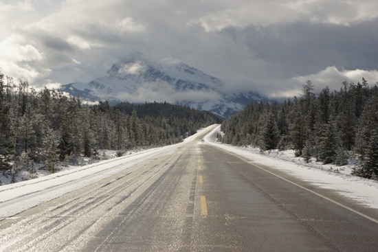
My drive up the Icefields Parkway, three days earlier, had been mostly cloudy. On this day, I was hoping for some better weather. Indeed, the clouds were quite interesting, as we began the journey. Mount Hardisty was somewhat visible, but I was hoping for more.

Driving by the edge of Mount Kerkeslin, I found one of the first patches of ice on the road. Yes, I’d call this “fair”.

Looking west, there are several dramatic pyramid-shaped peaks. This might be Mount Edith Cavell, or perhaps Geraldine Peak. It’s hard to tell with the clouds in the way — but it was still a beautiful sight.

A few kilometers further south, on the south side of Athabasca Falls, Highway 93 runs alongside the Athabasca River. That might be Mount Christie.

And a bit further down the road, it’s the mountains on the northeast side of the road that grabbed my attention. I think this is the south side of Kerkeslin Peak, among other mountains.
Endless Chain

You’re about 1/3 the way to Lake Louise when you get to the Endless Chain. This lengthy ridgeline is at the top of a perfectly slanted mountainside, that does indeed seem to stretch on forever.

The road was still looking pretty “fair” at this point, but there was enough snow on the shoulder to make this a slightly risky stop.

Still “fair”? Maybe. Getting closer to the climb to Sunwapta Pass, I looked back at that Endless Chain. Looking in this direction, you’d never know…

… that there were patches of blue sky in this direction. And speaking of patches, that’s about all I was seeing of pavement at this point. The road was mostly snow-covered, but still easy to drive, so long as I didn’t need to slam on my brakes at any point…

… say, for caribou. These special speed limits are posted in zones where animal crossings are likely. I’m fairly certain that during winter, you’ll travel the entire length of the Icefields Parkway without seeing a police officer. I tried my best to observe the speed limits, and most of the time I was happy for an excuse to slow down. Other drivers, though, didn’t seem very concerned with obeying the law. 70 kilometers per hour, by the way, is about 43 miles per hour — a speed that feels quite slow. (In non-wildlife zones, the speed limit is 90 km/h, or 56 mph.)

I took one last look back at the Endless Chain, to see the peaks being touched by just a little bit of sunshine. Yes, that road is looking pretty dicey.

Before climbing towards Sunwapta Pass, the road runs alongside the Sunwapta River, through a wide, flat valley. I’d say this part of the road rates at the very low end of “fair”. And we hadn’t even begun the climb yet.
Slushy, dirty roads aside, this is a very beautiful stretch of the Icefields Parkway. Up ahead is Mount Athabasca, elevation 3,491 meters (11,453 feet).

It’s a fairly straight shot on to the Icefields Centre area, and Athabasca Glacier, which is near Sunwapta Pass. When I passed through this area three days ago, the road was clear, but the snow was pouring down.
Sunwapta Pass – Icefields Centre

At least this time, I had a view of Athabasca Glacier. It’s the flat area in between the mountains.

I took this picture in the parking area, across the street from the Icefields Centre — the visitor center and transportation hub for trips out onto Athabasca Glacier via an Ice Explorer bus. The Icefields Centre is built on Athabasca Glacier’s terminal moraine — the rock and soil piled up by the glacier, when it reached its largest size, back in the 1840’s. Yes, back then, this entire area would have been covered by the glacier.
Just a minute or two south of the Icefields Centre, you’ll cross Sunwapta Pass, and cross from Jasper National Park into Banff National Park. Sunwapta Pass is at 2035 meters, just 34 meters lower than Bow Pass, to the south. After Sunwapta Pass, the road heads downhill…

… and at the bottom of the grade, you’ll swing around a dramatic, wide curve, then cross a bridge over Nigel Creek.

Mary Ellen and I received a sobering reminder of the dangerous road conditions, as we approached Nigel Creek Bridge. In the middle of the bridge, a station wagon had spun out and crashed into the guardrail. I parked, and we both jumped out and ran to the damaged car, fearing that we’d find injured people inside — or worse. Instead, we found no one. The crash must have happened earlier, and the driver and passengers apparently caught a ride with someone else who stopped to check on them.
That smashed-up Subaru caused my nerves to tense. I had been driving over snowy, icy surfaces, knowing it was possible that I might slide a little. But the possibility of crashing my car, or even injuring my hitchhiking passenger didn’t seem real until that moment. From then on, I kept a much tighter grip on the wheel, and said a few extra prayers.

Our next stop as we headed southbound was the Weeping Wall, a popular destination for ice climbers in the winter.

This stretch of the road had more bare, wet pavement, but those slushy ruts also provided a challenge. In places, it was tough to keep the wheels in the ruts. Climbing a hill through slush was especially tough — at one time Mary Ellen asked if there was something wrong with the car. It felt like it was “chugging”, as it hit slick spots, then solid, then slick again.

There must be something magical about the Saskatchewan River Crossing. Just like my earlier pass through this area, once again, it was sunny here, and blue skies peeked through the clouds to the east. No doubt, it would have been another beautiful day to take the side-trip out Highway 11 towards Abraham Lake. On this day, though, I didn’t have time, and I was quickly getting exhausted of driving.

Just south of Saskatchewan River Crossing, I stopped to look back to the north. Once again, the road was getting icy. And as I headed further south, and higher in elevation…
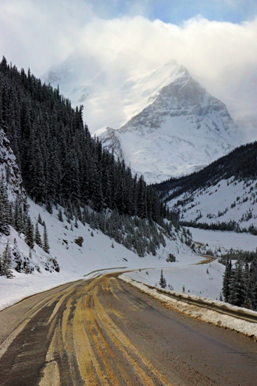
Bow Pass

… the pavement disappeared completely. This is Bow Pass, the highest point on the Icefields Parkway. And as such, it was also the most treacherous. With that earlier car crash on my mind, I didn’t stop much along this stretch of road — I was entirely focused on getting safely through it.

Downhill from Bow Pass, I found a familiar turnout at Bow Lake. On my previous trip to this area, in 2009, I had taken a good picture of the blue-green lake, Mount Jimmy Simpson behind it, and the red roof of Num-Ti-Jah Lodge, on the lake’s north shore. I was able to line up a similar shot this time, to provide a great set of images that, I think, illustrate the vast differences between winter and summer along the Icefields Parkway. Keep in mind, the photo on the top is not a black-and-white image — there’s just so little color anywhere in winter, that it looks that way.
Mosquito Creek
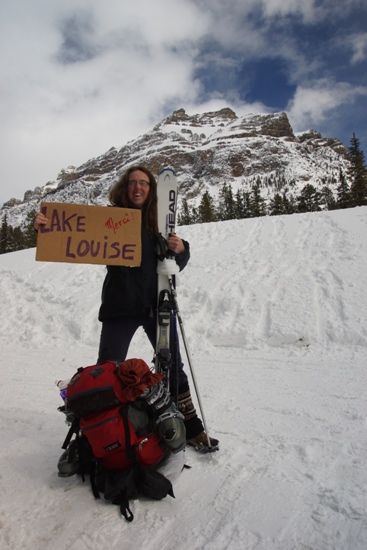
Just a few kilometers south, it was time to say goodbye to my traveling companion. Mary Ellen’s stop was the hostel at Mosquito Creek (not quite Lake Louise, as her cardboard sign indicated). There are rustic cabins here, though they’re note visible from the road. I felt like I was dropping Mary Ellen in the middle of nowhere, but she assured me that she was meeting friends here, and that she would spend the next week of her spring break skiing.

Beyond Mosquito Creek, it was only about 30 kilometers to Highway 1, and Lake Louise. The car was quiet and lonely — just as quiet and lonely as it had been for 9 of the past 10 days, but now I was noticing it. And even though I had the freedom to stop wherever I wanted, without worrying about delaying someone else’s trip, I was too exhausted from the drive to take many more pictures.

Well, I did stop for one, in the rear-view mirror. Remember that sign that said “fair” at the north end of the Icefields Parkway? Down here on the south end, “fair” wasn’t illuminated, “poor” was. Yep, that seems about right.
I had completed a goal that I had set, two and a half years earlier. I saw the Icefields Parkway at a very unwelcoming time of year. I’m glad I did it, but I don’t think I’d do it again soon. Or maybe ever.
Drivelapse Video
Here’s the time-lapse, dash-cam video of the drive from Jasper to the Endless Chain area…
… the Endless Chain, over Sunwapta Pass, and on to Saskatchewan River Crossing…
… and from the river on to the end of the Icefields Parkway:


No comments