

After a long climb uphill, the road rides the crest of the hills, making you’ll feel like you’re driving on top of the world.

There is a good opportunity to take in the view at a roadside stop, complete with pit toilets and picnic tables (the only facilities you’ll find until you reach the park).
Gila Cliff Dwellings National Monument is simple to visit. There’s only one attraction (the dwellings), and only one trail to reach them (a one-mile loop). When you enter the park, make a left to reach the trailhead, or continue straight to the visitor’s center.

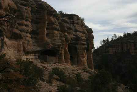
The trailhead is nestled in a scenic valley. Look up, and you’ll notice the cliffs are pockmarked with caves. This erosion provided the perfect location for Native Americans, the Mogollon people, to build their homes more than 700 years ago. The ruins can’t be seen from the start of the trail, though, since they’re around the corner.

The trail to the cliff dwellings climbs slowly, except for one short stretch, where steps are carved into the rock. Survive this part of the trail and you’re almost there.
Once the toughest part of the trail is behind you, you’re on eye-level with the ruins. From here, the trail winds around. But before you move on, take a moment to think back 700+ years, and consider something amazing: the view looked almost the same then, as it does now. In fact, an ancient homeowner probably stood right here, admiring his home.

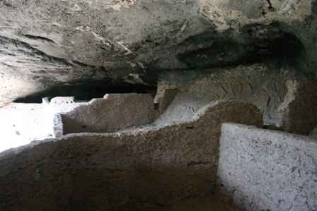
You’re not allowed to enter the first cave, but that’s ok, since you can see everything from outside. Those circles in the floor were probably used to hold large pots. In other words, this was probably a kitchen.

The second cave is also off limits, but there are a couple of important things to notice from the outside. First, the doorway. The Mogollon people who built this home weren’t content with plain, square windows and doors. They showed some creativity here, with a “T” shaped opening. (“T” shaped doors are a common theme throughout the southwest, but it’s not known why.) Second, notice the wood beams. This was a two-story house. Tree-ring dates from the logs date back to the late 1270’s and 1280’s.
When you reach the third cave, the path takes you inside. I hesitated at first, since the guides warn you not to go inside, however, what they mean is “stay on the trail”… and don’t climb over any walls, or stomp around in any individual rooms.

Near the back of the cave, there are no walls–just one big room, complete with a level floor. Was this a storage room? a living room? a playroom for the kids?
Notice the black soot on the roof of the cave. Historians believe it was left here by hunters who built fires in the cave, before the time of the Mogollon.

This is the view from inside, looking back the way you just came.

The third and fourth caves are connected by a stairway, that takes you over the wall that separates them.

Imagine this being your view! Maybe the Mogollon decided to live in caves, because it was just really cool!
Another view of the walls that separated the caves into rooms. In all, there are about 40 different rooms in the entire complex.

As you leave, take one last look back at these ancient homes, and consider what it must have been like for the Mogollon people to leave here, after about two generations. They left almost no clue as to why they left, or where they went.
Note: This trip was first published in 2006.


No comments