
Leaving Kodachrome Basin, I decided to take on a small adventure. There are only a few roads that cut across the Escalante – Grand Staircase National Monument, and one of the most useful, and most scenic, is the Cottonwood Canyon Road. The 40 mile dirt path connects Cannonville with US 89.

For the first few miles past the turnoff to Kodachrome Basin, the road is flat and somewhat boring. Even during dry conditions, you will need to drive through at least one small stream, that runs over the road surface. I made it through easily in an economy rental car. But it’s important to remember, conditions were very dry during my visit. If it has rained recently before your trip, this road may be impassible (even if you are driving a 4WD vehicle).

A few miles south of Grosvenor Arch, the road crests a hill, providing your first glimpse of Cottonwood Canyon. As soon as you see it, you know you’ve reached someplace special. There’s a remarkable amount of color here: in the dirt, the plants, the rocks, and the sky. And, there’s much more to be found, as soon as you venture off the road.

This is the view from the bottom of the canyon. You’d be crazy not to stop for a few minutes, so make use of one of several pull-off areas at the side of the road.
Also from here, you can venture just about 100 feet off to the side of the road, and explore a cool slot canyon.

From the road, there are a couple of places to access the slot canyon. You’ll have to drop down a ledge, that’s about 4 feet high (and climb back up it, to get out). Once inside, you can walk in either direction, exploring around one twist after another.

In many places, the walls are easily 100 feet high, or taller, and throughout the canyon, there are plenty of places where you could touch both walls at the same time… just stretch out your arms.
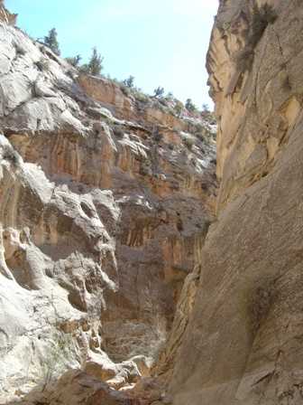
The greatest things to experience here, are the solitude, and the silence. If you’re not making any sound, there is no sound.

A narrow dead end in Cottonwood Canyon.

The canyon’s cool curves seem to swallow you up.

Another narrow “slot” passage.

After climbing out of the slot canyon, and back onto the road, I climbed up onto one of the outcroppings of rock that seem to jut up everywhere. This photo gives a good example of the “Cockscomb” range of jagged rocks.

Here’s a challenge, as you leave the canyon: stop again at the southern end, and try to capture this exact picture. While doing my pre-trip research, I found a photo taken in this exact spot, on the excellent americansouthwest.net website. It inspired me so, that I made it my goal, to capture the exact same photo. If you visit their site, you’ll see, I came pretty close (if only I had been standing at the other side of the road!)

As you continue south, the landscape changes several times. The road changes from a light colored dirt, to dark, and the plant life changes from lush and green, to dry scrub.
You’ll continue to wind your way up…

… and down small hills. The road is relatively smooth here, so if you’re growing tired of the rough, slow ride, you can put your foot on the gas, and make up a little time.

This barren part of the drive shows just how important a little water can be, in the desert. While the road traverses nearly barren, black soil, just to your right, you can see the bright green plant life, that lines the creek. My visit in springtime made this even more apparent, as new leaves were just unfolding on the trees.

The final few miles of Cottonwood Canyon Road depart completely from the canyon, traveling through badlands where it seems almost nothing grows. The road was also at its worst here: so severely washboarded in places, it felt the car would shake into a thousand pieces. There’s nothing you can do, but slow down… way down… until you’re almost crawling.
Above, you see the southern entrance to the Grand Staircase – Escalante National Monument, just a mile or two north of US 89.

Here’s how the BLM describes Cottonwood Canyon Road (#400), on the sign at the southern end of the path.

If you’re starting from the south, here’s the vital information: 40 miles of dirt, 46 miles to the next sign of civilization. And whatever you do, DON’T tackle this road when it’s been raining (unless you have a very good 4WD vehicle, and are SURE you know what you’re doing!)
Note: This trip was first published in 2004. I visited this road again on a later trip. Check it out here.


No comments