
As you leave Eureka behind, setting out on another long stretch of the Loneliest Road in America, you’ll have some mountains to admire as the miles fly by.

Stop and stretch your legs at a “rest area” in the middle of the very long stretch across the basin.

Signs say the area was planted with crested wheat grass in 1955, but it looks more like typical desert brush to me.

There’s also an original concrete Lincoln Highway marker here. It’s one of several you will see along Route 50.
Hickison Petroglyphs

There’s another reason to take a break from the Loneliest Road, as you reach the pass at Hickison Summit. Drive down a short side road, park your car, and walk a half-mile loop trail, to see some ancient rock carvings.

I don’t know a lot about the Hickison Petroglyphs. There was only one sign at the trailhead, which told me I should take a brochure, which would explain everything along the trail. Only problem was, there were no brochures in the box. All the petroglyphs along the trail were marked by numbers which corresponded with listings in the brochure, so I was out of luck.
Even without the guide, I was able to spot some of the carvings, left by Native Americans long before there was such a thing as America.

There isn’t much information about the Hickison Petroglyphs on the internet, either. But from what I’ve been able to gather, this is an example of the “Central Great Basin Curvilinear” style of rock art — in other words, curvy lines chiseled into rock. It’s believed that Indians used the mountain pass as a hunting site, where they would wait for wildlife to pass.
The petroglyphs are in good condition, but they’re hard to see, since they weren’t carved in rock varnish, like carvings in some other places.

A side trail splinters off the main loop, and leads to a viewpoint…

… where you can see the impressive Toiyabe Range, the second longest mountain range in Nevada. The view from the viewpoint isn’t much different…

… than the one you get as you pass through the next basin. The road eventually reaches those mountains…
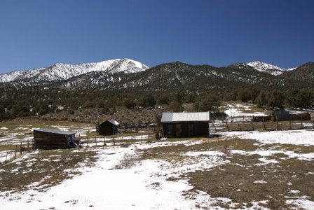
… then passes through them. Surprisingly, I found an old homestead at the side of the road…

…near Bob Scott Summit (elevation 7,267 feet). From here, the road starts to drop down into the next basin, and along the way, it passes through the third town on the Loneliest Road: Austin, Nevada.


No comments