
As you drive down Highway 111 from Palm Springs, you’re slowly going downhill, although you probably won’t notice it. Eventually, you’re on Highway 86, heading south along the western shore of the Salton Sea, and unknowingly, you’ve dropped below sea level.
Once you know how low this area is, it makes perfect sense that a huge body of water could form here, quite by accident. The Salton Sea is only about a century old: this deep basin (only five feet higher than the lowest point in Death Valley) started filling up in 1905, when a flood on the Colorado River forced the water to cut a new path. The Salton Sea is no longer fed by the Colorado, but there are smaller rivers that drain into it — but the Sea has no outlet.
Maybe it’s because of its unusual formation that the Salton Sea looked quite murky and grey when I drove by. Or maybe it was just because of the cloudy skies. Either way, it appeared foreboding, just like a couple of the small towns that are perched on its banks.
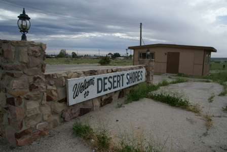
Desert Shores isn’t actually a “town”, it’s a community with a few hundred residents, most of which appear to live in some very long-neglected surroundings.

There are a lot of boarded-up businesses and homes here. The rest range from mobile homes to small block houses, some lovingly cared for, others falling apart.

There isn’t really a good place to stop and appreciate the Salton Sea. I couldn’t find a park or public space, just several jetties sticking out into the sea, looking as if someone forgot to build the docks or send in the boats. Only a few houses occupy waterfront spaces, the rest are inland.

Back at the Highway 86 frontage, there are a few businesses, including a bar and restaurant…

… and a grocery store. The whole place is strange; it feels abandoned, but not empty.

Down the road a bit, Salton Sea Beach feels much the same, though perhaps slightly better maintained. I never saw the marina…

… but I still found houses like this one, old trailers, and junk scattered about.
After exploring those two communities, the fun had worn off, and I was ready to bid the Salton Sea adieu. I didn’t bother with a drive through the only actual “city” around these parts (Salton City). Instead, I took a right onto County Route S22 (Borrego – Salton Sea Way), and headed…
Driving Into Anza-Borrego State Park

Anza Borrego is a real desert gem, and there’s a lot to explore. The park takes up 600,000 acres — 1/5 of San Diego County. It’s the second-largest state park in the United States, and a drive through it can easily take a big portion of your day.
On the way into the park, I passed an area popular with off-road vehicles…

… then made my first stop at this viewpoint of the Santa Rosa Mountains, which fill the park’s remote northeast corner.

The road is relatively flat as you head towards the town of Borrego Springs. Although it’s not part of Anza Borrego State Park, Borrego Springs is completely surrounded by the park. If you’re planning on driving the full length of the park, get used to hopping in and out of the park boundaries — it happens many times, as the road passes through ranchland and past private communities.
By the way, those mountains up ahead (including Indian Head Peak, at 3,960 feet) are on the opposite side of town, and the most popular hiking trail in the park, the Borrego Palm Canyon Trail, runs right through them.
Drivelapse Video
Here’s the time-lapse, dash-cam video of the drive down Highway 86, then into Anza Borrego State Park:


No comments