
As you travel towards the southern end of Anza Borrego State Park, you’ll cross over several mountain passes. During my visit, these vistas were made even more dramatic, thanks to the passing rain clouds.

Click here to view a larger version of this image.
At one moment, I’d be driving through sunshine, and the next…

… I’d be struggling to keep my camera dry, as I took pictures of rainbows that frequently appeared.
On the drive south, the main road follows the old path of the Great Southern Overland Stage Route. It also darts in and out of the park’s borders. Whenever you’re outside the limits, you’ll pass by a few houses and an occasional ranch.

Drive into Vallecito County Park for a look at a reconstructed Butterfield Stage Coach Station. There are also campsites here.

Just a short distance beyond the stage station, highway S2 runs alongside the Agua Caliente Springs Airport — although use of the term “airport” is somewhat generous. It’s just a lonely airstrip, where you might find a couple of small planes.
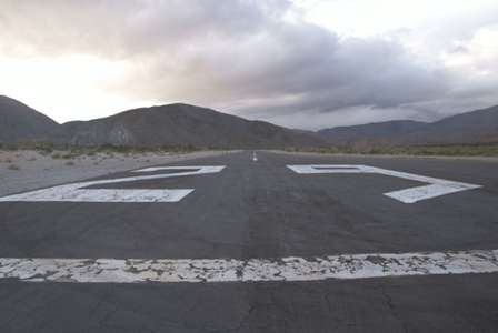
The landing strip is just a few steps away from the side of the road, with no fence or warning signs standing in your way. Just be sure to keep an eye out for approaching planes.

For the next few miles, the road skirts the edge of the mountains, but remains relatively flat as it heads to the southeast. There are several side roads that lead to trails and other attractions along here, but most of them start with signs warning of deep sand. I wasn’t in a 4-wheel-drive vehicle, and I didn’t feel like taking a risk, so I stayed on the pavement until…
Carrizo Badlands Overlook

A dirt trail at the side of the road leads to a few good viewpoints of the Carrizo Badlands. The lighting wasn’t great when I was there — another cloud had appeared overhead…

… but the mountains in the distance were interestingly lit.

Looking back in the opposite direction, the weather looked much more ominous than it actually was.

From here on to Ocotillo and the Interstate 8 entrance, Highway S2 is mostly straight, but as you can see, it’s very lumpy. At least you can enjoy the view of the Jacumba Mountains in the distance.
Drivelapse Video
Here’s the time-lapse, dash-cam video of the drive south through Anza Borrego State Park (part 2):


No comments