
It was early in the morning on my second day in Acadia. I had watched the sun rise on Cadillac Mountain, and I had a little more than two hours before I was due in Bar Harbor for a kayak tour (which didn’t happen, but that’s another story). I had heard that there were several good hikes that started at the Sieur de Monts section of Acadia, so I stopped in and talked with the rangers at the Sieur de Monts Nature Center for some suggestions on two hour hikes. They suggested a scenic route to the top of Dorr Mountain, Mount Desert Island’s second highest hill.
But I screwed it up. About halfway up the trail, I didn’t notice a split in the path, and ended up heading back downhill. By the time I realized I was headed the wrong way, it was too late to backtrack and complete the trip.
In other words, here’s the story about my journey halfway up Dorr Mountain: a route that will take about an hour. Though it doesn’t make it to any summit, it does provide some nice views and a good workout.

As I mentioned, there are a lot of trails in this part of the park — so many, it can get confusing, even at the start. The only marked trail near the Sieur de Monts Spring is Emery Path. Other trails are in the woods, just a few yards away, but there aren’t any signs for them here.

The Emery Path wastes no time heading uphill. You could take Emery all the way to Schiff Path, to the top of Dorr Mountain, but the rangers suggested a more scenic route for me.

On the rangers’ advice, when Emery Path crossed Jesup Path, I took a right.

Jesup Path is an easy, level trail that’s suitable for just about anyone. It’s beautiful, too: Jesup Path passes underneath a towering canopy of trees, all of which were brilliantly colored in early October.
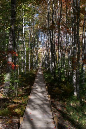
Jesup Path eventually turns into a boardwalk. Following instructions, I turned to the left, just before the boardwalk began…

… onto Hemlock Road…

… then almost immediately, turned again onto Homans Path.

Homans Path is an alternative to Emery Path. It, too, is a steep climb, with lots of rocky steps…

… and even a short tunnel through solid rock.

Here is the reward for all that climbing. Homans Path lifts you up above the Great Meadow. In fall, it’s an especially beautiful sight.

Another narrow squeeze took me in between two huge slabs of rock, and beneath another underpass…

… as the stairs kept climbing.
Eventually, Homans Path once again intersected Emery Path…

… and I continued to follow Emery uphill, through another narrow cut in the rock, and up yet another stone staircase.

Click on the image to view a larger version.
The panoramic view to the east is fantastic here. In the foreground is the Great Meadow, and in the distance, you can see Bar Harbor and a cruise ship offshore.
Yes, everything was going well up until this point. Then…

… I arrived here. At this point, Emery Path ends, and Schiff Path begins. Schiff leads on up Dorr Mountain, crossing the Dorr North Ridge Trail just shy of the summit. But if you take a close look at the signpost, you’ll notice another sign, at the bottom, pointing in a slightly different direction. It points towards Kurt Diederichs Climb. I didn’t notice the fork in the trail. I didn’t see Schiff.
As I trudged along the trail, I was enjoying heading downhill. I thought it was just a momentary break, and the ascent would begin again in mere moments. But then I kept going. This was a strange way to reach the top of a mountain, I thought. No, this didn’t seem right at all.
After a few minutes, I stopped, and pulled up the photo I had taken of the trail map. It started to make sense. I had taken the wrong trail. And with my appointment looming in Bar Harbor, I didn’t have enough time to climb back uphill, then continue on to the top of Dorr Mountain.

Not to mention, at this point, I had no desire to climb up Kurt Diederichs Climb. Kurt must have been one heck of a dude. This was an extremely steep trail.

A bit disappointed, I kept heading downhill, taking just a few pictures along the way. The trail was beautiful, but it stayed hidden beneath the trees for most of the time. There weren’t as many sweeping vistas on Kurt’s trail as there were on Homan’s Path.

Kurt Diederich’s Climb, and my descent, ended at Jesup Path. Remember that nice, level trail at the beginning of the hike? I was back on it again, albeit a different section. Jesup Path returned me to Sieur de Monts. The entire hike took about one hour, leaving me with another hour to burn.
My failure to summit Dorr Mountain made me determined to return here to try it again, if I had the chance. And I did! On the following day, I made Dorr Mountain my final objective, before leaving Acadia and heading down the coast.


No comments