
About halfway up the Precipice Trail, I met a couple climbing down. The guy said, “Isn’t this great? It’s like they turned a mountain into a jungle gym!”
I can’t think of a better way to describe a trail that should certainly rank as one of the most challenging and, at times, scariest in Acadia National Park. The Precipice Trail makes a very quick ascent to the top of Champlain Mountain (1,058 feet/323 meters), by way of its eastern face — a sheer rock wall.

This is the trail. It starts off with a scramble over boulders, then goes straight up the rocky hillside. I can’t say I wasn’t forewarned:

Hikers are greeted with numerous warning signs at the trailhead. They tell you that exposed cliffs and “ladders” are ahead. Now, when I think of a ladder, I think of the kind of thing that helps me get up on my roof — something like you see in the last picture on this page. But here, “ladder” has a different meaning, which I’ll show you in just a moment.
After a few minutes of scrambling over the boulders at the foot of the hill, and trying to spot the blue blazes that mark the trail…

… the path reaches its first dramatic cliffside moment. I didn’t find it to be the least bit reassuring that one of the planks was already missing from this footbridge. That railing didn’t exactly feel very solid, either.

Mileage-wise, you’re nearly halfway to the top, when you reach this split in the trail. Heading straight would take you on the Orange and Black Path — though when I was there, a sign suggested that the Orange and Black Path was damaged and closed to hikers (a warning that wasn’t important at this stage of the hike, but mattered later on). I rounded the hairpin curve and continued towards Champlain Summit — while quickly discovering that the most challenging (and fun, and scary) part of the trail was still ahead.

Can you spot the trail here? That blue mark is the only thing that even remotely suggests that this is a good place to walk. Believe it or not, narrower “shelves” were still ahead.

After a brief break from rock scrambling and cliffhanging…

… I came upon one of the Precipice Trail’s many “ladders”. These rungs reminded me a lot of what I found on the Via Ferrata at Nelson Rocks in West Virginia. The only difference was, on the Via Ferrata, a safety cable ran the entire length of the trail, and you had to keep your safety harness hooked into the cable at all times. On the Precipice Trail, there were similar rungs…

… and similar cliffs, but no safety cable. I thought back to what I had learned on the Via Ferrata: always keep three points of contact. If you’re going to move your foot, both hands should be holding onto something. If you’re going to move a hand, keep your feet firmly anchored until you’ve grabbed onto your next target.
At places where the trail was especially narrow, there were rungs at hand-level, and others by my feet, to keep me secure. But, there were a few spots where it seemed like an extra rung would have been helpful.

Another ladder…

… and another narrow shelf. Notice the rungs on the right side of the photo.

All this climbing and risk-taking was gradually paying off, with views that gradually became more spectacular. This photo looks north, with the islands off Bar Harbor in the distance — and some fall colors in the foreground.

Almost at the top, the thrills continued.

Notice the road below. That’s the park loop road. Sand Beach is nestled in the tiny bay, next to the small peninsula of land (known as Great Head) in the middle of the photo, Thunder Hole and some of the island’s best rocky coastline are just out of sight, behind the cliff.

The most intense part of the climb is done, when you see this weathered, scratched-up sign. It warned that going back down is more difficult and time consuming than the ascent. It suggested a different trail for the return trip (Bear Brook Trail, which isn’t called Bear Brook anymore — rather, “North Ridge”).

I still wasn’t quite at the top of Champlain Mountain. There were nice views here…

… before the trail (now much easier, but still uphill) cut through a small patch of autumn-colored trees…

… then crossed a sheer rock face to reach the peak of Champlain Mountain. It would have been nice to hang out here for a while, and savor my victory over the Precipice, but the bald top of Champlain Mountain offered nothing to stop the howling, cold wind.
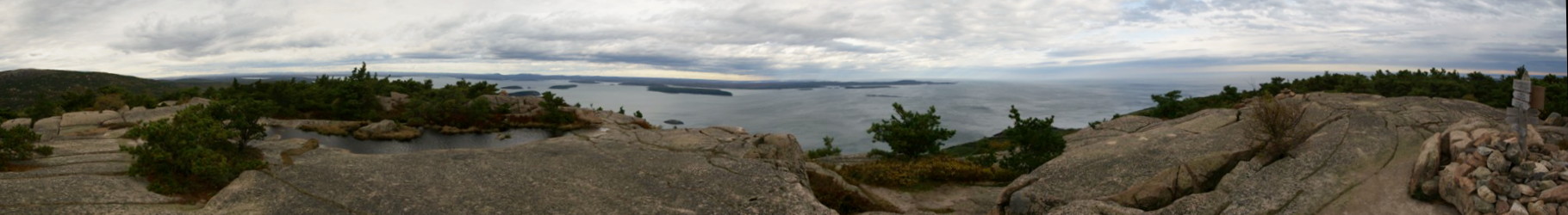
Click on the image for a larger version.
I snapped a panorama as quickly as I could. I’m surprised it turned out this well.
Then, I hunkered down for a moment and weighed my options. I could descend the Precipice, ignoring the advice of that old, weathered sign, that warned it could take twice as long, and be more difficult going down. Or, I could follow the North Ridge trail — a path I hadn’t researched beforehand. I knew the ridge wouldn’t lead me back to my car at the Precipice trailhead. But at the same time, I thought about the scariest parts of the climb — those few areas where I had to briefly ignore the “three points of contact” rule, and hope for the best. I thought about the parts of the trail that were wet and slippery. I knew from my experience on the Via Ferrata, that going down was tougher than going up.
Eventually, I opted for the North Ridge trail.

The North Ridge trail was, indeed, easier than the Precipice. But it had one big drawback: as the name suggests, it stayed at the top of the ridge. That meant I had little or no protection from the howling wind.
Since it was getting late, and the best of the scenery was behind me, I put the camera away, and focused on quickly hiking downhill. The entire trail looks about the same as this picture — the view doesn’t change much along the way.

On the way down, I crossed paths with the Orange and Black Path. Taking it would have been a little more pleasant (it stays away from the road, and in the trees), but I wasn’t sure if it was open. So, I opted to continue down the North Ridge trail, headed towards the loop road.

Before reaching the road, I found only one spot that was worthy of a photo — this supersized footprint in the rock, complete with “toes”.

When I finally intersected the road, I was just a little more than a mile away from the Precipice trailhead. Walking along a road isn’t nearly as thrilling as a hike on a trail, but I still enjoyed this part of the trip. Acadia’s loop road is so graceful and thoughtfully constructed, that it’s nice to experience it at a slower pace.


No comments