
Once again, I was back at the Frozen Lake Junction. I had gone left and I had gone right, so this time it only made sense to go down the middle, on the Wonderland Trail.

From the junction, the Wonderland Trail loses a little bit of elevation, then passes through an area of mostly barren tundra, looking a little bit like the surface of the moon — assuming, of course, that the moon had a 14’er for you to stare at, as you hopped weightlessly between craters.
This first part of the path is wide-open and beautiful, with great views of Mount Rainier for a while, until you drop down a little further, and the Burroughs Mountains get in the way. Since it was early afternoon, the sun was beginning to make its move behind Rainier, which made it a little tougher to photograph, but still pleasant to gawk at.

About .7 miles from Frozen Lake, the trail splits. I really should have stuck with the Wonderland Trail, because it stays high, gaining a little elevation to end up atop the ridge you see in the middle of the picture above. The trail to Berkeley Park Camp goes down, down, down, meaning I would have to climb back up, up, up to get back to Frozen Lake. But, I thought I had read something promising about Berkeley Park (I didn’t bother to actually pull out my guidebook and see what it said, mind you). So, I took the low road.

From its split with the Wonderland Trail, the trail to Berkeley Park continues on for a mile and a half (until the camp — the trail goes even further beyond that). It makes a wide swing around the top of the valley, then runs down the side of Skyscraper Mountain (the peak you see on the left).
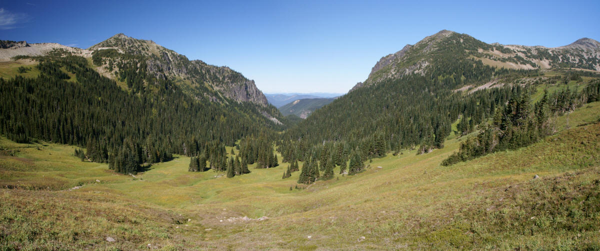
Click on the image for a larger version.
About halfway around that wide arc, you’ll have a great view, looking directly north, through the passage between Skyscraper Mountain (on the left) and Mount Fremont (on the right).
Later on, when I finally got around to reading my guidebook, I found out that it suggested I stop here, at this great viewpoint. It said the wildflowers would be astonishing here (guess I was a few weeks late). It also said that there was little value in hiking on to the camp. Yep, I should have read that first.

That’s not to say that the rest of the trail was without merit. After rounding the arc, the trail dipped in and out of trees, occasionally passing through clearings that were quite beautiful (and would have been even more beautiful with a prolific wildflower bloom). The constant presence of a babbling creek made it even nicer — except that in places, the creek made the trail quite muddy.

Looking back, it was obvious that I was going to have a lot of uphill hiking to do. At the top of this picture, you can see the Burroughs Mountains, and just below, about halfway down the green hillside, the Berkeley Park trail.

But still, I continued on, along the narrow trail, ducking in and out of patches of trees…

… and through one rocky meadow after another. Yes, it would have been a very beautiful place, had the wildflowers still been blooming.
If there’s one photo that made this hike worthwhile…

… it’s this one. I captured a nice picture of the small cascades, on the stream that runs through Berkeley Park. In most spots, the creek is out of reach, but there’s one location where you can sit on a rock, right along the creek’s edge. It’s a beautiful, green, peaceful place, almost nice enough to get me to forget about that long, long hike back uphill.
The trek to and from Berkeley Park was the last segment of my hike for the day. I returned to Frozen Lake, rested for a while, and ate a snack. A breeze had kicked up, making the temperature (in the 40’s F/perhaps around 8 C) feel much more bitter. I braced myself against the wind as I sat for a while, building up the energy for the final push back to Sunrise. When all was said and done, I think I hiked about 11.2 miles, in about 7 hours this day.


No comments