
Highway 6 is one of the most scenic roads you’ll find in the Canadian Rockies. Maybe it’s not quite as stunning as the Icefields Parkway to the north, but it’s still a special treat, especially as you drive southbound from Pincher Creek. And since Pincher Creek is the nearest sizeable town with a good supply of hotels, there’s a good chance that your visit to Waterton Lakes National Park will include a least one, or maybe several, round-trips on this highway — which is okay, since the park is only about 56 kilometers (35 miles) away from town.

Day 3 ended up being the most spectacular day of my trip, weather-wise, but it took a while for the sun to come out. As I left Pincher Creek, the sky was still fog-covered and grey. Even so, the photo opportunities started appearing immediately.

This photo looks back towards the Pincher Creek area. If you look closely, you can see the edge of town, and about a hundred of the power-generating wind turbines that are scattered over the landscape around Pincher Creek. (I’m not certain why this photo turned out so blue, but it’s better than the grey, so I kept it.)

With a few exceptions, Route 6 runs almost perfectly straight southbound, with the mountains of Waterton Lakes and Glacier National Parks looming in the distance. It’s a non-stop show of jagged peaks and snow-covered slopes.
If, like me, you’re traveling this road in Winter, you can expect to be all alone out here. There’s almost no reason for anyone to drive this road at this time of year, since Waterton is a ghost town in the winter, and the road to the international border (Hwy. 6’s southern end) isn’t plowed. Make sure your gas tank is full, before you leave Pincher Creek, and stock up on snacks and water, too.

As you head to the south, the mountains are right in front of you, and on your right-hand side. For a closer look, I took a random road that led to the west, and ended up in Pectin, at some kind of industrial area — which seemed out of place amongst the natural surroundings. I think this is a natural gas plant, operated by Shell.

That side road led to some nice photo opportunities, so long as I avoided the giant smokestack.
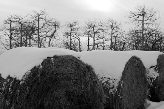
In addition to the gas plant, there are some ranches out here, which are still working, even during the winter months. Snow-covered bails of hay always make for good photos.

Since I was driving through the area early in the morning, I got the chance to see something that’s rare. These plants weren’t covered with snow — they were glazed with something known as Hoar’s Frost — a build-up of extremely delicate ice crystals. An hour later, and it likely would have been gone.

I was starting to see some blue sky in patches, which gave me hope for the day.
Eventually, Highway 6 crosses into the edge of Waterton Lakes National Park. The first attraction you’ll find is the Bison Paddock.

During my visit in March, 2012, the fenced-in bison area was closed. I’m not sure if it’s always closed in winter. The road out to it was snowy, but passable.

The bison paddock fence was also covered with Hoar’s Frost — but with the sun preparing to come out, this would be the last of it I saw.
After the bison paddock, Route 6 runs into Route 5, which will take you on into the park, and to the town of Waterton. A kilometer further, and Routes 5 and 6 split. Route 6 heads south to the border, while Route 5 turns east to Cardston (another option for nearby hotels, that’s just about as far away as Pincher Creek).
Drivelapse Video
Here’s the time-lapse, dash-cam video of the drive from Pincher Creek, south to Waterton Lakes National Park:


No comments