
This is the part of US 550 that earned the name, “Million Dollar Highway”. It’s simply spectacular to drive, any time of year. An incredible waterfall, guardrail-free drop-offs, and mining relics make the journey interesting, and the destinations on both ends (Silverton and Ouray) are both worth your time. Plan properly, and with some luck, you’ll pass through this area at the peak of fall colors — which makes a great road even better.
My Visit
When I think back on my entire trip around Colorado in early October, 2014, one day stands out as the best day of all. Remarkably, it was the day with the worst weather. Instead of pushing myself to drive a few hundred miles, or hike a dozen miles, I gave myself the day off. I booked two nights in Ouray. With gloomy weather moving in, I figured I’d just putter around town for the day, and perhaps drive over Red Mountain Pass to Silverton.
Because of the weather, I figured I’d take very few pictures. But, I caught a break. The cold rain tapered off into a light drizzle. Then, the clouds lifted, just high enough to allow me to see my surroundings.

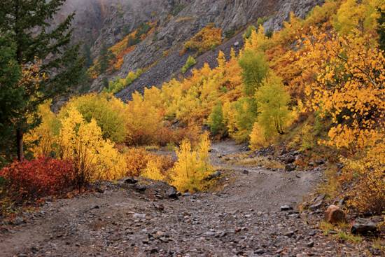
I drove down US 550, heading south. One of my first stops was at this short tunnel, which was blasted through a rock wall. The lack of sunlight didn’t dim those bright leaves.
If you’re looking for a good hike, consider the Bear Creek Trail. It begins on the opposite (south) side of the tunnel, and it actually crosses over the tunnel, then continues uphill. An 8-mile round-trip hike (out and back) takes you past a couple of historic mining operations, and provides sweeping views of the surrounding mountains. The trail is designated as a National Recreation Trail, an honor that emphasizes the trail’s remarkable scenery.
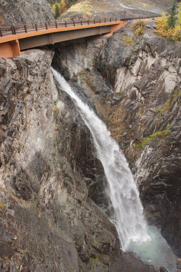
Just a short distance beyond the tunnel, you’ll cross this bridge. I’ve driven over it several times, and I never knew I was passing over a huge waterfall! This is Bear Creek Falls, the site of a toll booth on the original Million Dollar Highway, way back in the 1880’s.

The original highway was constructed by Otto Mears, an early pioneer of road and railroad construction in this area. He charged $5 for a wagon team to pass over the bridge. Given its location, there was no way to sneak around it. $5 was a lot of money in the late 1800’s, but it was well justified, considering that the most challenging parts of the road cost $1,000 per footto construct.†

You won’t see Bear Creek Falls unless you stop at the turnout, get out of your car, and walk all the way out onto the viewing platform. This explains why I had never seen it before. And I’m willing to bet, half the people who stop there don’t see it, either. They probably assume that the most noteworthy sight to behold is this waterfall, on the opposite side of the canyon. It, too, is quite beautiful, especially during autumn when the vegetation around it changes colors.
Continue south…

… until you see the turnoff for the Alpine Loop. Unless you have a Jeep, or some other offroad vehicle, you will not be driving this road.

It’s rough. Very rough. And unless you have an appropriate vehicle and some offroad driving skills, you should avoid it. Just having an 4-wheel-drive rental SUV is not enough, sorry.
I had a compact rental car, so I knew I wasn’t going up this road. Instead, I decided to hike it for a short distance. It didn’t take long…

… before I was high enough to get a nice view of US 550.

Along the way, I was passing through a stunning display of fall colors.

The dirt road makes one switchback…

… and then another.

Before I knew it, I had gained a good bit of elevation, and my head was in the clouds. The mist swirled around the canyon walls around me. If it had been sunny, it also would have been beautiful — but nothing like this.
If I had gone much further, I would have encountered a couple more switchbacks… and then, who knows? My hike lasted about 4/10 of a mile, one way.

Back on 550, and just up the road from the Alpine Loop turnoff, you’ll be passing through one of the most thrilling stretches of the Million Dollar Highway. The road travels along a “shelf” carved into the mountainside — there’s a steep hill on one side, a steep drop on the other, and in most places, no guard rails. It’s either thrilling or scary, depending on your feelings about heights.

You’ll notice an old chute from a mining operation at the side of the road.

Keep going up the canyon. From here to the pass, US 550 follows Red Mountain Creek — although it’s quite a long distance below you, at the bottom of the canyon.

Just before arriving at Red Mountain Pass, you’ll see the remnants of the Idarado Yankee Girl Mine. A scenic overlook area provides a good viewpoint.

It looks a lot better on a sunny day under blue skies. I took this picture on my 2012 trip across the Million Dollar Highway.
As I climbed closer to the pass, I was hoping the added elevation would turn the rain into snow. And it did!

Big, wet flakes were pouring down at Red Mountain Pass.

The pass separates Ouray County and San Juan County.
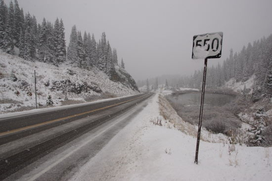
Even though the snow was coming down hard, the road was still slushy. I saw a plow truck pass through the area a couple of times. US 550 stays open year-round, although the high spots could close briefly during snowstorms.
I spent a few minutes shooting this video of the snow.

As I dropped down from the pass, I noticed this old relic at the side of the road. I carefully cropped out the huge “for sale” sign below it.
Beyond the pass, it’s about 10 miles to Silverton. On this side, the snow quickly turned to rain as I descended, and it wasn’t nearly as pretty, so I didn’t take any more photos until I arrived in Silverton.
The Bottom Line
This road is perfect during the fall colors, but it’s fun to drive on any day of the year — even the foggy, rainy, and snowy days.
Location
This page deals specifically with the “Million Dollar Highway” portion of US 550, between Ouray and Silverton, Colorado. This part of the road crosses over Red Mountain Pass.
This section of highway is also part of the larger San Juan Skyway scenic byway loop, that includes towns like Durango and Telluride. If the loop was a perfect circle, the Million Dollar Highway portion would be near the 3 o’clock position.
Drivelapse Video
Check out this time-lapse, dash-cam video of the drive over Red Mountain Pass on the Million Dollar Highway, between Ouray and Silverton:


No comments