
Proxy Falls is a pretty impressive waterfall, just a short hike away from the McKenzie Highway, Oregon Route 242. Better yet, it’s just one of two big waterfalls you’ll see on this hike.
My Visit

I had been dealing with rainy weather all day, but I wasn’t about to let the soggy conditions keep me from hiking to some of the waterfalls along the MacKenzie Highway. Proxy Falls was one of my goals, and even though it was far from ideal to set off on a 1.5 mile hike in a cold rain, I was feeling pretty determined.
As you can see by this picture, my lens was already either fogged up, or smudged from the constant raindrop-wiping.

Proxy Falls Trail begins, directly across the street from the vault toilets. The trail is a loop trail, and the other end of the loop comes out at the end of the parking area — about a hundred feet away from here. That end isn’t marked, which I’d guess is an effort to keep everyone hiking in the same direction.

The trail takes you through a surprisingly colorful field of lava rocks. You’re going to be seeing a lot more igneous rock as you visit the Bend area.

All of a sudden it’s a 2-way trail? The sign is a little confusing, which is probably why someone added a suggestion (“this way”… to the right).

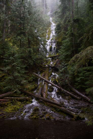
You’ll come to Lower Proxy Falls first. It’s 226 feet high, and it’s one of the most recognizable (and most often photographed) waterfalls in Oregon. From the trail, you’ll get to view it through a natural window — a break between the trees. For a different perspective…

… scramble down to the base of the falls.
Oh, I wish it hadn’t been raining when I was here. Between the water falling from the sky, and the spray from the waterfall itself, I decided it was too risky to keep my camera out of the bag for long. I snapped just a couple of pictures, then put the camera away.
I don’t know if there is an easy way to get back up to the main trail. If there is, it’s not the way that I used. I got quite lost as I tried to make my way through the woods and back uphill to the “window”. I ended up overshooting the trail and scrambling across some slippery rocks and through some thick vegetation. In other words: as you’re going down, pay attention to how you got there.
Back on the loop trail, it’s not long before you run into Upper Proxy Falls. This waterfall feels like it’s sort-of “around the corner” from the Lower Falls. This waterfall is only about half as tall as its bigger brother, and it’s fed by a different source — so the two don’t really have anything in common, aside from proximity. The Upper Falls isn’t quite as picturesque, either. Again, I could have done a better job photographing it, if everything hadn’t been so darned wet.
I finished the loop trail and returned to my car, soaked to the bone by the cold rain. Little did I know, I had an even less pleasant stop up ahead, at McKenzie Pass.
The Bottom Line
Two waterfalls on a 1.5 mile loop… what’s not to love? Okay, in my case, the weather wasn’t very pleasant. But, if you’re lucky enough to pass through this area on a warmer, drier day (although cloudy is better than sunny for photos), you’ll enjoy the hike out to Upper and Lower Proxy Falls.
Location
Proxy Falls is located on the south side of Oregon Route 242, the McKenzie Highway, about 9 miles east of the junction of 242 and 126. The loop trail to Upper and Lower Proxy Falls is about 1.5 miles.
You’ll need a Willamette National Forest Recreation Pass to park at the trailhead. An Interagency Annual Pass (National Parks Annual Pass) is also accepted — it should be okay to leave it on your car’s dashboard.
Drivelapse Video
Check out this time-lapse, dash-cam video of the drive from Salem to Detroit Dam…
… Detroit Dam to Dee Wright Observatory…
… and McKenzie Pass on to Bend:


No comments