
It’s the “other” way into Crested Butte — a dirt road with excellent scenery that’s easy to drive. County Route 12 takes you across Kebler Pass, and through an immense grove of aspen trees. Time your visit exactly right, and you’ll get to witness a spectacular show of fall colors.
My Visit
If you want to see a colorful explosion of fall colors, you go to where the aspens are. And if that’s your goal, why not go to one of the largest aspen groves on earth? If you’re in Colorado near the end of September, or early October, you really need to take a drive on…

… Gunnison County Route 12, part of the West Elk Loop Byway.
I took this drive back in 2010, in the summer, and I couldn’t help but notice all the aspen trees. As it turns out, scientists have noticed them, too. Some argue that the aspen grove along Route 12 around Kebler Pass is one of the largest, if not THE largest living organism on earth. Since the trees reproduce through roots that spread out, the trees are essentially clones of one another, with the same DNA. They’re all one big tree, stretching out for acres and acres.
A couple of years ago, some researchers declared the Pando grove in Utah as the world’s largest organism, but in 2014, some Colorado tree geeks suggested that the Kebler Pass grove may be even larger.
So I ask, who wants to see the (possibly) world’s largest living thing, put on a show for fall?

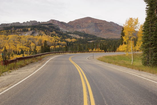
This time, in 2014 (just like in 2010), I was traveling eastbound on Route 12. If that’s the way you’re going, you’ll notice that for the first few miles, nothing is extraordinary. I mean, it’s more beautiful than any spot in at least two dozen other states, but on Colorado standards, it’s just your average drive through a valley. The road follows Anthracite Creek for a while, before gaining some elevation and cranking up the ooh’s and ahh’s.

The mid-section of Route 12 constantly flirts with Marcellina Mountain. At first you see it from the side…

… and then the road swings around, and you’re staring at its eroded southern face. And just look at that impressive stand of aspens, all at the peak of color!

Face the opposite direction, looking south, and a wide-open expanse stretches out before you. West Beckwith Peak and East Beckwith Mountain rise in the distance. In between, the treetops form a colorful carpet that seems to never end.

It isn’t until you’ve circled around Marcellina, and started to leave the mountain in your rear-view mirror, that you plunge into the aspen grove.

A side road, narrower and rougher, offers another opportunity to explore.

The main road remains easy to travel throughout the trip. It’s wide, there are few potholes, and you could easily drive it at 30 miles per hour or more, if not for the scenery.

Just before you make the final climb towards the pass, you’ll notice an area known as “The Kebler Dike”, where it’s common to see a few trees turn a brilliant red, instead of yellow.

There are plenty more aspen trees alongside the road, as it makes its final climb towards Kebler Pass.
I don’t recall seeing a sign at the actual pass — and both times, I wasn’t sure exactly when I had crossed it. As you go up the hill, the road is suddenly paved again. It’s after you’re back on the pavement that you cross over Kebler Pass. Once the road joins Coal Creek, you’re on the Crested Butte side, headed for town.

On both of my visits to Crested Butte, I haven’t spent the amount of time that the city deserves. Crested Butte has a nice old-west feel, but it’s also a tourist town, bolstered by the nearby ski resort. In the summer, there are plenty of other outdoor recreation opportunities, including hiking and mountain biking.
Of course, I’m sure your biggest question is, “When do the leaves change?”
I made this trip during the first week of October — specifically, I drove this road on October 8, 2014. Everywhere I went on that trip, people told me that the leaves were late that year. So, it may be better to plan your trip for the last week of September, or the first couple of days of October. Of course, drought, an early cold snap, or a windy storm could change the peak days. Even if you’re not lucky enough to hit it exactly right, you’ll still have a great time.
The Bottom Line
I’d suggest taking a drive over Gunnison County Route 12 at any time of the year (once the snow melts), but it’s especially enjoyable during autumn, when the fall leaves are at their peak. Plan to make this drive in late September or the first week in October, and you have a good chance of catching some fall color.
Location
County Route 12 over Kebler Pass begins at Paonia State Park, along Colorado Highway 133. From Interstate 70, exit at Glenwood Springs, and follow Highway 82, then 133, south for about 55 miles.
The other end of County Route 12 is along Whiterock Avenue in Crested Butte, Colorado. It’s about 31 miles from Crested Butte to Route 133. The alternative is a 130 mile loop through Gunnison, Colorado.
County Route 12 is closed during the winter months. Check with CDOT for current road conditions.
Drivelapse Video
Check out this time-lapse, dash-cam video of the drive over Kebler Pass on County Route 12:


[…] – Featured Cover Photo Credit: Take My Trip […]