
When the sun doesn’t shine at Mount Rainier, the park’s beautiful centerpiece vanishes from view. And since weather around the mountain can be so unpredictable, you need to have a backup plan. During the first three days of my week-long visit to Mount Rainier, the sun didn’t make an appearance, and areas like Sunrise and Paradise were fogged in. So, I decided to seek out some waterfalls — which photograph better on cloudy days, anyhow.

Comet Falls is one of the best waterfalls in the park, but it requires some effort to get to it. Comet Falls is 462 feet high, with its biggest, most dramatic drop measuring 392 feet. It looks more like a waterfall you’d expect to see in Hawaii than in Washington.
Getting here requires a 1.9 mile (one way) hike, that steadily climbs uphill for almost the entire distance.

The trail begins at this trailhead, at the side of Paradise Road, about 4 miles west of Longmire (it’s just before you get to Christine Falls). After that first climb up the stairs from the parking area…

… the trail levels out somewhat, as it parallels the road, heading towards Christine Falls.

A foot bridge takes you over Van Trump Creek. If you look to your right…

… you can almost see the brink of Christine Falls, as well as just a smidgen of the road, which crosses over the creek, providing the frame for a perfect picture (from the Christine Falls viewing area, down below). In the opposite direction…

… there are more, unnamed waterfalls that cascade through a narrow chute. This is the same creek that flows over Comet Falls, so it should come as no surprise that the trail stays fairly close to the creek for at least some of the hike.

There is not a lot of incredible scenery on the way to the falls. The trail darts in and out of forested areas. In this clearing, a field of brush was covered with brilliantly green leaves — so brightly colored, they looked unreal on this otherwise grey day.

After more trees…

The trail runs along the edge of a ravine, washed out by big floods of the past.

I’m not sure you should nibble on these berries, but they looked an awfully lot like raspberries. If you feel confident in your wild-berry-identifying skills, go ahead and give them a try. If they are edible, you can have your fill — they grow here by the thousands.
As the trail climbs, it comes fairly close to a moderately-sized waterfall. This might be Van Trump Falls — a waterfall that isn’t well publicized, probably because it’s not easy to access or photograph. This is the best shot I could get, without risking my safety.

When you see this big rock, good news! You’ve nearly made it to Comet Falls. But first…

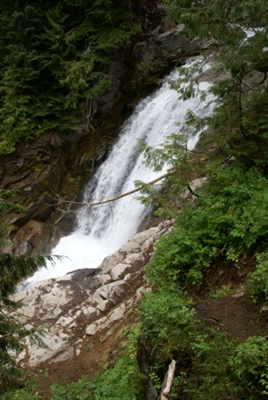
… you come upon another waterfall, which also isn’t very well advertised. It would be an impressive destination, if Comet Falls wasn’t so close by. This series of cascades is known as Bloucher Falls or Upper Van Trump Falls. It drops in three tiers, and is about 130 feet high from top to bottom.

I’ve read that flooding in 2003 changed the look of Bloucher Falls, and I believe it also took out the footbridge that used to cross the creek here. Now, there’s a log bridge that allows you to cross to the other side, and on to Comet Falls.

From the far side of the footbridge, you’ll find a few good locations for photographing Bloucher Falls. Be careful, though — after my visit, someone told me that another visitor to the park (a fellow Floridian, no less) had died here, just a few weeks earlier, when he got too close to the rushing water, slipped in, and was swept downstream.

Before the flood waters swept through in 2003, there was much more vegetation surrounding the falls. Now, they’re a bit less beautiful, with much more exposed rock.

It’s easy to spend a lot of time taking pictures here, forgetting that there’s an even bigger waterfall nearby. In fact, Comet Falls is so near, that you can see part of it from Bloucher Falls, if you know exactly where to look.
Beyond the footbridge, the trail goes up the small hill and back into a wooded area. Moments later, you emerge from the trees, and are greeted by this sight:

This is Comet Falls. It’s somewhat difficult to get a good picture of all three tiers. It was even more difficult when I was there, because (as the drops on my lens attest) it was pouring rain.
A couple more switchbacks take you closer to the most impressive part of the cascade.
It looks like the trail is going to run directly to the base of the upper tier of Comet Falls. But, there’s another switchback (close to where those people are standing) that takes you on up the hill, towards Van Trump Park.

I waited for the other hikers to clear out, and the rain to slow down a bit, then took a few pictures of the trail and the falls. You can go farther than the switchback…

… and if you do, you’ll probably find some nice wildflowers to incorporate into your photos. While this isn’t an official part of the trail, I could have easily walked all the way down to the base of the falls, though if I had, I would have gotten even more soaked, thanks to the generous spray from the waterfall.

Continue up the trail and back into the woods, to find a view of the falls that’s nicely framed by the trees. Or, if you’re like me, you’ll retreat to this area for protection from the rain.

Here, the trees grow out of the side of the slope, then turn upward.
It would be a shame to hike this far, and not continue on to beautiful Van Trump Park. At this point, you’ve already come nearly 2 miles from the parking lot, and gained about 900 vertical feet. Pushing on to Van Trump will require another 1.3 miles of hiking (the official distance, I think it might be a bit more, especially if you wander past the end of the official trail). You’ll also gain another 1,100 feet — meaning the rest of the trail is almost twice as steep as the part that brought you here.
I’ll describe the hike from Comet Falls to Van Trump Park on the next page.


No comments