
One of only a handful of roads that takes you into the Grand Staircase-Escalante National Monument, Cottonwood Canyon Road is a bumpy adventure over dusty, washboarded dirt that takes you through some amazing Utah scenery. Along the way, you’ll find a striking double arch, a slot canyon hike, and one of the most colorful, bizarre little canyons you’ll ever see.
My Visit
I’ve made three trips down Cottonwood Canyon Road — okay, actually two trips down it, and one up it. The first was in 2004 — it was the primary goal of that entire trip. I had seen a picture of the spectacular Cottonwood Narrows canyon, and I was determined to experience it in person. On the second trip, I drove north, and thankfully I had an SUV on that trip, because the road was especially challenging.
In 2013, for my third visit, Cottonwood Canyon Road was merely a side attraction — something to do, to fill a couple of hours before settling in for the night in a cabin at Kodachrome Basin State Park. I decided I’d drive down the road, just far enough to see the Narrows one more time, then turn around and come back. I’ll combine all of these adventures here, so that you’re not missing anything.

There isn’t a single inch of Cottonwood Canyon Road that isn’t scenic in one way or another. Just south of Cannonville, you’ll be stopping to take pictures, as you pass through some colorful ranchland.

The road is still paved at this point, although it lacks a center stripe. You’ll climb over this pass and down the other side, and find the entrance to Kodachrome Basin State Park. From there, the road turns to dirt, and eventually, it climbs again…

… crossing another pass, where you can look back on a sweeping view of the Basin.
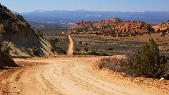
Looking back to the north, you’re facing Cannonville, and Kodachrome Basin is slightly to the right. You can look back on the road you just traveled…

… and then look ahead, to the next hill you’ll need to climb.

A small sign marks the turnoff for Grosvenor Arch (pronounced like “Governor”, with an extra Grrrr at the beginning). A mile down the side-road, you’ll reach a lonely parking lot, picnic tables, and a path out to the foot of this hill, where the arch becomes apparent. You can read more about my previous visit to Grosvenor Arch here.
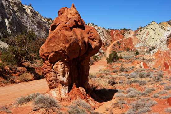
Backtrack from Grosvenor Arch to the main road, then drive about five more miles south. The landscape becomes increasingly awesome, until you reach a spot that’s truly incomprehensible:

This is the bizarre little valley that was my destination. Every time I’m here, I simply cannot believe my eyes. Everything is strange and wonderful here — so many pieces of geology, none of which seem to fit together exactly right.

There are enough parking spots in this valley for two, maybe three cars. I drove on over the next hill and parked on the other side, then walked back, and wandered around for a while.
In addition to the mind-boggling scenery along the road, this valley is also the start of the Cottonwood Narrows, a 1.5-mile journey…

… through slot canyons. If you enter the slot canyons here, you can exit to the south, and use the road to hike back, giving you a 2.5-mile loop.
On the 2013 trip, I didn’t hike into the slot canyons — I didn’t have time. During my 2009 visit, I hiked a short distance north and south from the entry point, but didn’t hike the entire loop, partially because I was recovering from a bout with food poisoning (particularly not fun during a vacation). On my 2004 visit…

… I explored the slots briefly, but got a little spooked by the quiet and remoteness of the area, so I didn’t stay long. Hey, back then I was still new at all this. I’m a little braver now.
On the 2013 trip, I drove back to Kodachrome Basin after visiting the Narrows area — but here’s what you can expect if you go further south.

First, there’s the Coxcomb. This is a jagged series of peaks, that you can easily see on a topographical map of the area. While on the west side, things remain quite colorful, but eventually the road crosses over to the east side…

… into a bleak landscape, which is still beautiful in its own way. Even when it meets up with the Paria River…

… it still looks like a wasteland (although you will see some green Cottonwood trees near the water during the summer months).
The Paria River can cause damage to this part of the road. The road is maintained, to some degree, even though the road signs say it isn’t. Even so, you might need a 4-wheel-drive in spots. Also, you should NEVER drive this road when it’s raining, or just after a storm. The dirt turns into a sticky mud, that’s impassable by almost any vehicle.
Also worth noting: park rangers and the staff at the local BLM visitor centers may not know the current condition of the road. They often depend on reports from everyday people who’ve driven, or attempted to drive, the road. During my 2009 drive, the staff in Kanab hadn’t talked to anyone who had driven the road on that particular day, so I headed into the drive with my fingers crossed. It was a pretty big risk — if I had run into a washout, I would have had to turn around, then make the entire 133-mile loop on the paved route.
The Bottom Line
If you’re confident in the car you’re driving, and you’re not afraid to take a risk and drive out into the wilderness, then you should definitely find time to drive Cottonwood Canyon Road — at least as far as the Narrows and Grosvenor Arch. But before you go, make sure you talk to someone locally about road conditions, and make sure you have a full tank of gas, and plenty of food and water.
Location
Cottonwood Canyon Road connects the tiny community of Cannonville, Utah, on State Route 12, with US 89 (about halfway between Kanab, UT and Page, AZ). The paved route (U-12 and US 89) would take 133 miles, and while the dirt road cuts that down to 46 miles, the travel time will likely be similar.
Only the first few miles of Cottonwood Canyon Road, from Cannonville to Kodachrome Basin State Park, are paved. Once the dirt begins, it’s about 10 miles south to the turnoff to Grosvenor Arch (and another mile on a side road), then five more miles to the Cottonwood Narrows, where you’ll find the slot canyon trail. Further south, the road follows the Coxcomb, a jagged mountain ridge, then crosses a barren badland, before its end at US 89.
Drivelapse Video
Check out this time-lapse, dash-cam video of the drive from Bryce, Utah (U-63 at U-12), east on U-12 through Tropic and Cannonville, then down Cottonwood Canyon Road:


No comments