
I decided to start my Colorado vacation with a drive to a destination that simply can’t be missed: North America’s Highest Auto Road, leading to the top of Mt. Evans.

Rte. 103 is an uphill climb, the entire way. And that makes sense, considering you have to gain about 6,500 feet. The road winds through a thick pine forest until you reach timberline.
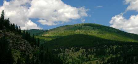
Even everyday mountains like this one appear spectacular on the first day of your trip. Give yourself a week in Colorado, and you won’t even notice them.

Pull off at Ponder Point for a quick stretch-your-legs stop, and a view of the road you just climbed.

After 13 miles, Rte. 103 comes to a beautiful mountain lake (Echo Lake), a tacky gift shop, and this sign. From here, the summit of Mt. Evans is only 14 slow, steep miles away. The road becomes curvy and rough, so those 14 miles will take at least 30-45 minutes to drive.
Bristlecone Pine Forest

Just a few miles after you’ve paid your admission, and begin your climb up Mt. Evans, you’ll reach the Mount Goliath Natural Area, where a grove of ancient Bristlecone pine trees grow.


A short, paved loop trail leads you through the bristlecone pine grove, providing great views like this one.
Summit Lake
Before you reach the final series of switchbacks to the top of Mt. Evans, you’ll want to stop at Summit Lake.

Summit lake lies in a glacier carved cirque, and is half surrounded by steep cliffs. Several trails take you down to the edge of the cool, crystal clear water.

You’ll need to stay on the trails, and off the grassy meadow. Any steps off the path can damage the grass and wildflowers.

Several trails begin at the Summit Lake parking area, including a short, 1/4 mile walk to the Chicago Basin overlook. I should have taken the time to hike there, but didn’t.

Drive to the end of Mt. Evans road, and you’re just 130 vertical feet from the summit.

Just as you’d expect, the view from this altitude is incredible.

From the top, you can look down on Summit Lake…

… and look back on the road you just climbed.


While atop Mt. Evans you’ll enjoy a great view of the mountains and valleys below (after all, at this elevation, there’s almost nothing higher than you!) You’ll find this Rotary International plaque near the parking area.

Also near the end of the road: the burnt-out remains of Crest House, a restaurant and gift shop. It was built in 1942, and burned in 1979.

The Crest House’s stone walls still remain, and have been made safe for visitors to explore. The shell of the old building also provides for some great photography opportunities, when other visitors aren’t in the way.

Next door to the Crest House, you’ll find another, much newer building. The Meyer-Womble Observatory opened in 1996. At the time, and until 2000, it was the highest observatory on earth. It’s run by the University of Denver.
Mountain Goats

On your way up or down Mt. Evans Road, keep a close eye on the rocky, grass-covered tundra. You’re likely to see some wildlife blending in with the surroundings.

I probably wouldn’t have noticed these mountain goats, if not for other tourists who had stopped at the side of the road.

Aside from mountain goats, you may also be lucky enough to spot big horn sheep, mule deer, and marmots (a rodent similar to a beaver, but without the tail). I didn’t spot any marmots on Mt. Evans, but I did find a den of marmots in the mountains near Silverton.
Arapaho National Forest

Once you’re back on the main road, you’ll pass a few turnouts that provide parking at the side of the road. At least one of them was a worthwhile stop.
This shady creek was perhaps 100 feet from the road, but felt quite isolated. While the stream wasn’t exactly a mighty waterfall, it was still provided a good location for a few photos.


Note: This trip was first published in 2005.


No comments