
After the long, winding drive up to the Continental Divide, you’ll probably be ready to stretch your legs and tackle a trail. At Logan Pass, you’ll find two: the short and incredibly popular Hidden Lake Trail, and the much longer Highline Trail. We’ll begin with the trail to Hidden Lake, which begins directly behind the visitor’s center.
The trail to the Hidden Lake Viewpoint is about 3 miles roundtrip. If you decide to hike on to the lake itself, that’ll take another 3 miles roundtrip. I’ll refer to the viewpoint trail as the “first half” and the lake trail as the “second half”.
Most of the first half of the trail is a boardwalk. You have to stay on the walkway to avoid damaging the delicate arctic plant life that grows here. The trial is roughly at tree line, so there are only a few struggling firs along the way.
As you can see from the picture above, you’ll be making a slow climb as you hike up to the base of Clements Mountain. From this angle, Clements Mountain appears to stand alone atop the Continental Divide, but actually, it’s just the tail end of a long range, that towers above Hidden Lake.

As you climb up the gradual slope above the visitor’s center, you can look north to see the Garden Wall, a long, knife-like ridge (it’s called an arête). GTTS Road travels along the side of the Garden Wall for miles. In the foreground, check out the protruding rock. These were formed by an ancient inland sea, that once covered the area.

You’ll also pass a small swampy area, where water still collects. If you’re already exhausted at this point, just convince yourself that this is Hidden Lake, and turn around. Your friends at home won’t know the difference.

As you approach the foot of Clements Mountain, about halfway to the Hidden Lake Overlook, you’ll pass this small waterfall. Even in September, there are still some patches of snow hiding in the mountain’s shady areas, and as that snow melts, it trickles down here.

Standing right below Clements Mountain, you can see the layers of glimmering, colorful rock which make up the mountain.

The chances of running into some bighorn sheep, mountain goats, or other creatures along Hidden Lake Trail are pretty good. I came across several bighorn sheep near the viewpoint.
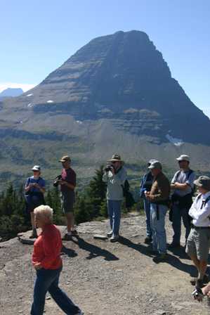
Any wildlife appearance always draws a crowd, with cameras snapping.

While any creatures you encounter in the wild could be dangerous, these sheep seemed to be well-adjusted to having humans around. They went about their business, walking alongside the path (and even across it, in front of a big crowd of tourists) as if this was their daily routine.

Just moments later, I came across several more creatures along the path. This time, they were mountain goats, and these guys appeared even more relaxed and laid-back than their bighorn neighbors.

An entire family was lying in the shade of some trees near the overlook, and drawing an even bigger crowd than Hidden Lake itself. When I took these pictures, I was no more than about 3 feet away from the group, and they didn’t seem to mind.

OK, take your attention off the animals for a moment, look the other direction, and check out this view! Hidden Lake is no longer hidden. The deep-blue surface of this calm, peaceful sanctuary lies about 750 feet below you.
As I gazed out on the lake and the surrounding mountains, I thought about the mile and a half I had just walked, and the prospect of hiking an equal distance further, to reach the water’s edge. It didn’t just seem worth it, it seemed essential. Surely, there could be no more perfect place on earth.
I’m still not sure, though, how I convinced myself that the hike down and back up would be “not so bad”.

At any rate, I continued past the viewpoint, onto the second half of the trail. While I was anticipating the solitude of the lake, I was already experiencing it here. Apparently everyone else who reached the viewpoint had made the somewhat lazy, yet very sane decision to head back to their cars, and continue sightseeing in a seated position.
Sadly, they’ll never know what they missed. At least, until they read this.
After passing the viewpoint, the trail stays level for a while, running parallel to the eroding mountainside. (Remember earlier, when I told you that Clements Mountain didn’t stand alone, as it appeared from the visitor center? Well here’s the proof: this long ridge is essentially the “tail end” of the mountain, and stretches on for miles.) It was perhaps a quarter-mile past the viewpoint that I entered an area so enchanting, I made up my own name for it. I call it the “Land of Magical Rocks”. Over the centuries, chunks of the mountain had eroded away, rolling down the hill and coming to rest here–everything from tiny pebbles to huge boulders. Most amazing was the range of colors: red, blue, green, yellow, grey, black. They were scattered everywhere, amidst the green tundra. The place simply felt magical, and I took a seat on one boulder for a few minutes, just to soak it all in.
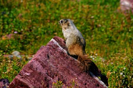
I wasn’t the only one. I spotted this creature, then waited for him (or her) to pose, and to my amazement, he (or she) did.

This guy scampered around on the rocks for a while.

After staying close to the cliff for a while, the trail finally begins to descend towards Hidden Lake. A direct path would be too steep, so instead, it makes four switchbacks as it drops into the valley. Even so, there are parts that are steep, and a few places that are rocky.

You’re almost there now. After the switchbacks, the trail straightens out and takes you directly to the water.

Once you reach the water, you can walk along the shore in either direction. In most places, there’s a path directly along the water, and another one a few feet back (you should use this one, so you’re not walking in front of people who’ve already staked their claim to a spot).

After passing almost no one on the trip down, I was surprised to find several people were here. So I did my best to get away from them, and turned left, walking a few hundred feet away from the end of the trail. It was here that I found my perfect spot: a large, flat rock that jutted out into the water. The picture above was the view to my right…

… directly in front of me (that’s Bearhat Mountain, towering 2300 feet above the lake)…

… and the view to my left (Reynolds Mountain, elev. 9,125′). I took off my shoes and plunged them in the icy water. Aside from my gentle splashing, there was barely a sound. I was surrounded by blue sky, green water, and mountains high enough to hold up heaven. The sun was intense, yet the air was still cool. I stuffed my backpack behind my head, laid back, and within minutes I was drifting off to sleep.
That is, until I heard “scamper scamper scamper” about an inch from my ear. I bolted up, looked around, and saw a chipmunk, who had already retreated to a safe distance. Oh well, so much for my nap. It couldn’t last forever. Besides, I had 3 miles of hiking yet to go, and a good portion uphill.
I should have spent a few more minutes at the lake, walking around to its west side. The view probably would have been beautiful, and so would have the pictures (since I would have been looking away from the sun, instead of towards it). But I was starting to be a bit concerned about the long hike ahead, so I started up the trail.

There are plenty of trees surrounding Hidden Lake, but you quickly leave them behind as you climb the trail.

The great thing about carrying a camera, is you can always pause to “take a picture”, even though what you’re really doing is catching your breath. I have dozens of pictures that look just like this, with a long, steep trail ahead.

Two of the switchbacks are close together, and the distance between is especially steep. Some of the trail more closely resembles a staircase.
Bottom line: it’s a long hike, and it’s exhausting, but making the full 6 mile round trip is definitely worth it. But, you need to have plenty of time, take it slow, and savor every moment. No matter how tired you get, you won’t regret it.
And, if you arrive back at your car, and decide you’re not ready to give up that precious Logan Pass parking spot just yet, you can always walk a few more miles on the Highline Trail. That’s our next stop.
Note: This trip was first published in 2006. Much of the same area was covered in the Big Sky trip in 2014.


No comments