
After a day spent crossing the Idaho panhandle, then biking down the Route of the Hiawatha, there was only one objective remaining for Day 3: make it to Kalispell for the night. It’s too bad the sun was about to set, because this drive through the northwestern edge of Montana was simply beautiful, in the kind of too-big-to-fit-in-a-picture way that you so often find in this state.
Location
From the Idaho/Montana state line, take Interstate 90 east to St. Regis, then follow MT Rte. 135 until it dead-ends. Turn left, and you’re on MT Rte. 200. About 9 miles later you reach Plains, and turn right on MT Rte. 28. MT 28 heads east, then north, then east again, ending at US Hwy. 93. Turn left on US 93 for the drive along Flathead Lake, and on into Kalispell.
My Visit
The first road after you turn off the interstate is Rte. 135. What a surprisingly beautiful highway! The two-lane road follows alongside the Clark Fork River. There are several places where you can pull over, climb down a small hill, and splash in the water.

When you make the turn onto Rte. 200, so does the Clark Fork River, which combines with the Flathead River, and follows the road north.
As you approach Plains, look for the intersection with Rte. 28. Also watch for the Subway restaurant at the corner. This fine place allowed me to recharge my camera battery when it started to fail.
The drive on Rte. 28 continues to be great. You pass through some rolling hills…

… and past this lake, which I believe to be Rainbow Lake. A clear, cool body of water like this would be filled with tourists in most places around the country, but here, you’ll probably have it all to yourself.

The hills begin to flatten out, and at Markle Hill, Rte. 28 turns north again…

… and for just a moment, you have a great view of the valley you’re about to enter, and the mountains that loom above it.
Allow me to make a recommendation: once you dip down into the valley…

… select a side road at random. They’re all dirt, and they all serve just one purpose: to connect the farmhouses in this area. You’re also bound to spot some scenes like this one…
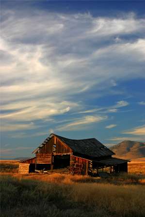
… and this one, that have been frozen in time for at least several decades.
Back on the main road, Rte. 28 eventually turns east again, crests a hill…

…and suddenly Flathead Lake comes into view.
It was just minutes after this stop that the most remarkable thing happened. The sun was about to set, and as it neared the horizon, all those wispy high clouds suddenly turned red. A bright red. The entire sky. By this time, I was driving alongside the lake, and as I glanced over, I noticed that the water had turned red too! For a few minutes I struggled to find a place to pull off, where I could see the crimson sky and the scarlet water.
By the time I reached West Shore State Park, the red sky was gone, replaced by a bluish haze that seemed to be falling down from the sky, and rising up from the lake all at the same time.

I am not sure what this picture of Goose Island would have looked like, with the fiery, glowing sky and water, but it still turned out okay.
With the light of the day gone, I drove on to Kalispell for the night.
Note: This trip was first published in 2006. Much of the same area was covered in the Big Sky trip in 2014.


No comments