
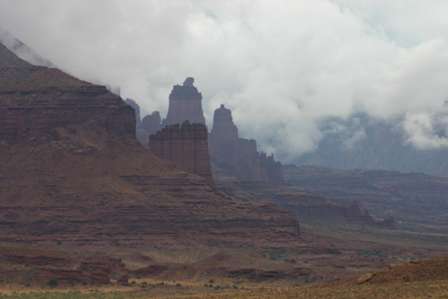
From Dewey Bridge on to Moab, Rte. 128 stays close to the Colorado River, as it drops down in between canyon walls. Before long, you’ll round a corner, and the dramatic Fisher Towers come into view.
The view from the road is impressive, so if you’re short on time, you don’t have to take the dirt side road to the base of the towers.

The road is a bit bumpy through this area.

Watch for a turnoff that leads to a parking area and trailhead, at the base of Fisher Towers. You’ll have to drive a couple of miles up a bumpy dirt road, but the view at the base is worth it.

As you can see, my visit happened on an unusually rainy day, so I didn’t get to enjoy the bright blue desert sky. But I did find a few puddles, that provided interesting reflections.


There are plenty of other interesting rock formations in the area, so don’t let Fisher Towers distract you from the rest of the landscape.

Note: This trip was first published in 2005.


No comments