
If you want to experience the southwest — all of the southwest — you should take some time to experience the Indian reservations that make up a large chunk of it. Since I was starting my day at the Grand Canyon, and hoped to end in Cortez, Colorado, the Navajo and Hopi Nations were in the middle of my path. And with hopes of visiting some places unseen by most outsiders, I decided to take a few backroads through the northeastern corner of Arizona.
There are a few things you need to know about driving across Native American land. First, it’s wise to obey their speed limits and their property, since these lands are policed by the Nations’ own authorities. You will probably feel like a bit of an outsider, even though you’re still inside the United States, so get used to it. Also, you’d be well advised to stock up on food, drinks, and gasoline before leaving the US highways. Bureau of Indian Affairs (BIA) roads aren’t lined with 7-11’s and Circle-K’s. There are some services, but they are few and far between.
The roads themselves are mostly in good condition and safely drivable, but you will notice some differences. In some places, I noticed no center or side lines, and directional signs and route numbers are almost non-existent. Carry a good map, like the AAA Indian Country map, and watch for landmarks and even curves in the road, in order to figure out your exact location.
One other thing I noticed as I spent the late half of Day 2 driving across the Navajo and Hopi Nations: the poverty. This is an intensely poor area. It gets a bit depressing after a while. Some towns might have one gleaming, shiny new building (usually housing a federally-funded school or clinic), but the rest of the buildings are either trailers or very simple block houses. They’re all painted in earth-tones, and often there’s a lot of junk surrounding them.

Amongst all that poverty is a strikingly beautiful landscape. Take these badlands, for example. These hills are right off the roadside, near the US 89/160 intersection. I wanted to hike up into them, but of course, I couldn’t.
Just a few miles down Rte. 264, I passed another example. It was a beautiful canyon on the north side of the road, perhaps a mile away. I could only catch an occasional glimpse as I drove, but from what I saw, it appeared to be a gully cut through white rock, exposing a peppermint-red stripe of color. I had never seen anything like it before, and I hoped that after a mile or so, there would be a side road that led to an overlook. But there wasn’t.
That was the first of many experiences that day, that left me wondering why these people don’t make better use of their blessed land. Such beauty combined with such great financial need should lead to some kind of an opportunity. But it never seems to happen here.

The road continued across Navajo Land, then entered Hopi territory (a small square in the middle of the much larger Navajo reservation). When the Moenkopi Plateau ended, the road dropped, then climbed onto Third Mesa (heading east, the Third Mesa is the first one you’ll cross, then Second, and finally First Mesa. Early explorers simply numbered them as they passed by, and the names stuck.)
I took a picture of the water tank at Hopevilla, because it was positively the ugliest water tower I had ever seen.

Looking back into downtown from the water tower, there’s the new, modern building on the right, a school on the left, and that’s it. No Main Street business district–just one very tiny convenience store (in the middle), that didn’t look inviting to outsiders.

I think the above picture shows the road as it drops down off of Second Mesa. As you descend this stretch of road, you’ll no doubt glance to your left, and see a striking rock formation. At the bottom, I found a road that climbed up towards the rocks, so I drove up it. It was a fun road, with a ridiculously steep vertical climb that ended with a hairpin curve, right next to the rocks. I was thrilled, until I saw that the obvious parking area at the side of the road was signed, “No Parking”. This was the only good place to stop and see the rocks up close, or perhaps take a picture, and I couldn’t.
This is the kind of thing that only grows more frustrating as you travel through Native American lands. Would it have hurt to allow people to park there? Or, how about actually paving a small parking lot, and putting up a few signs saying, “Come See The Rocks!”. The locals could potentially draw a few tourists into their struggling village.
In my eyes, this wouldn’t disgrace the land — they could still forbid kids from climbing all over the rocks. But, I guess the people who live here have a different view. I’m not saying that’s wrong, and I don’t mean any disrespect. I’m only saying that to an outsider, it’s a little frustrating.
Once you finish climbing back to the top of Second Mesa, you find a small Native American village there. I think it’s called Sipaulovi. It’s precariously perched atop the edge of the mesa, but it’s just as depressing as every other town along the route. I spotted signs for one business there, advertising cold drinks. But, the signs pointed to a building that looked like a house, and I couldn’t imagine walking in someone’s front door asking to buy a Coke. So, I turned around and headed back the way I came, around the hairpin curve without parking, and down the steep grade, bringing to an end what will likely be my only visit to Second Mesa, ever.

By the time I passed First Mesa, I was bored with Rte. 264. I knew I could continue on quickly to US 191, then up to Chinle, but I decided to delve a little deeper into the back country. So, at Keams Canyon, I turned north on what started out as a paved road. After passing this picturesque church, the road turned to dirt…

… then climbed the side of the actual canyon for which Keams Canyon is named. I’m betting it would be much more green in the summer months.
It was here that I noticed something different, than everything I had seen for the past few hours. Over the first couple of miles, there were several turnouts with picnic areas. Strangely, I suppose at some point someone decided to make this road, of all roads, a little more tourist-friendly.
If there was an effort at some time in the past, it didn’t last. The picnic areas were overgrown and dilapidated. Worse yet, everything in this area was covered with graffiti. I noticed that a lot, throughout Native American land. Often, the few route number signs that were posted were unreadable, thanks to all the spray paint.

The dirt road was fun, though. For a while it was flat, then it rounded some curves and dropped down to the desert floor. From this viewpoint you could probably see for 75 miles. Aside from a few small villages, it was nothing but a barren landscape.
I hit pavement again after about 13 miles, then finally found BIA Rte. 4, which I followed to US 191, and then Chinle. Along the way, I only found one other place to stop…
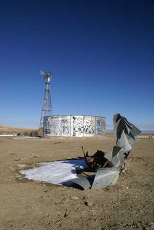
… at this windmill and water tank. The ruins of the old windmill and a few patches of snow made for some good pictures. Then a pack of wild dogs wandered up, stared at me, and walked away, and I plowed my rental car through some muddy dirt tracks to get back on the pavement.
Note: This trip was first published in 2006.


No comments