
From the crossroads (described on the previous page), I set off an unmarked road that turned off to the right (headed east, I think!). The short drive led to California Pass, elevation 12,930 feet, then continued into California Gulch.


I didn’t travel beyond the pass, but I didn’t need to. The view here was better than I ever could have imagined. Just a short climb uphill (from the sign pictured above) and you reach a great viewpoint. To one side, Poughkeepsie Gulch and Lake Como…

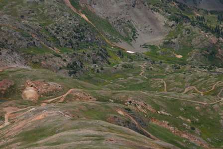
…and on the other side, California Gulch. The two couldn’t be more different: Poughkeepsie appeared harsh, while California was perfectly rounded, bottoming out at a small stream and another 4wd road. No matter which direction you travel from here, you can’t lose.
The above photo gives you a closer look at Poughkeepsie Gulch. Lake Como is on the lower left side, just outside the frame. From there the road twists and turns into the valley. We’ll tackle a small portion of Poughkeepsie Gulch Road on the next page.

Now here’s a good idea: navigate these roads aboard a dirt bike, instead of a big, bulky 4wd SUV. An ATV would have also been nice, and easier to maneuver over these mountains.
Lake Como – Poughkeepsie Gulch
From atop California Pass, beautiful Lake Como seemed just a short distance away, and incredibly tempting. But, to reach the water’s edge, it’s necessary to drive the narrow and dangerous Poughkeepsie Gulch Road.
I read the ominous road sign and decided it didn’t apply to me, since I was an experienced driver (although never before on roads like these!). So, I started down the road, with the simple goal of reaching the lake, then turning around.
Poughkeepsie was indeed rougher than any other road I had traveled that day, or on this entire trip. It was steep, with bare rock jutting into my tires. It was nothing I couldn’t handle, but still, I had to drive slow and remain focused.
Then, I reached a big problem: a small washout. I carefully tried to creep my way across, but when I felt my left front tire sink into the ditch, and my right rear tire leave the road completely, I knew I was in trouble. I slowly backed out, then set the emergency brake and stepped out of the car. The ditch was too deep to drive across, and turning around (or backing up) was out of the question. So, I decided to rebuild the road. Using nearby rocks, I filled in the ditch, creating a path just wide enough for my tires. Then, I drove slowly over the bridge I had built, making 2 or 3 attempts in order to hit it just right.
So was all this effort worth it? You tell me.

There are several good places to park near the edge of the lake.
Lake Como’s water is perfectly clear in shallow areas, and in the deeper areas, it’s a brilliant green-blue. As you might expect, the water is bitterly cold, even in the summer, since it’s mostly melting snow that fills the lake.


With slightly less wind, I would have captured a great reflection here.

Since this area is above timberline, there are no trees, but the alpine tundra does spring to life in the summer. August is a great time to find wildflowers blooming.
After taking in the quiet scenery for a while, I headed back up to the intersection (once again making it safely across my makeshift miniature bridge), then back-tracked my way to Silverton.
Back at the intersection, I found a family standing outside their car, and pointing. They had spotted a fox, or more accurately, the fox had spotted a potential easy meal.

Now, you’re not supposed to feed the wildlife, so I want to make it clear, I’m not the one who gave this critter a slice of bread. But I’m glad the other family did, because it kept the fox around long enough for me to snap a few good pictures.

After the snack, the fox wandered away, up the mountainside, all the while keeping a close eye on the humans who were watching him.

The trip back revealed more amazing scenery. I took this shot directly above Lake Como (you can see the edge of it at the bottom of the frame). If you look closely, you’ll also see my rear-view mirror in the corner, which tells you I shot this out the passenger-side window.

Even in August, this huge snow drift still stands as a testament to the rough San Juan winters.

Looking back towards Silverton, from near Hurricane Pass.

On my way downhill, I spotted some more wildlife: a family of marmots living in the rocks at the side of the road.

After waiting for a moment, about 4-5 creatures appeared from their small cave.

More wildflowers blooming!

There were several small waterfalls cascading down by the side of the road.

About halfway back to town, you’ll enjoy this great view of the Red Mountains, which are also visible from US Rte. 550 north of Silverton.

I found one more interesting scene as I headed downhill, on my way back to Silverton. A deep patch of snow was finally melting, with the help of the small creek that ran directly underneath. The result was a delicate shelf of snow.

I can only imagine how deep the snow must be here in the winter, if it’s still melting in August!

From the patch of snow, I looked back up at my car, and for a moment, I realized what it felt like to be living inside a Jeep commercial.
Note: This trip was first published in 2005.


No comments