
Cathedral Rock is one of the most recognizable landmarks in Sedona’s Red Rock Country. Even if you don’t hike up it, there’s a very good chance that you’ll be mesmerized by it, at places like Red Rock Crossing:

I’ll talk more about Red Rock Crossing, and the incredible views of Cathedral Rock reflecting in Oak Creek, later on. This page is all about the hike up to that “saddle” — the low part in between the bigger chunks of mountain. Look closely at the picture above. The saddle is just to the right of that finger of rock, that’s sticking up in the middle.
Now, let’s jump over to the other side of Cathedral Rock, and the other side of Sedona, where the trail begins.

After spending about five hours hiking along the popular West Fork of Oak Creek Trail, I was looking for a short, but rewarding, trail. Amongst the trail guides that I had printed off the internet, I found Cathedral Rock. It sounded easy–just 1.2 miles round trip. Perfect!
It took me about a minute of hiking to realize this was not going to be an easy trail. Oh no, this would be quite a challenge. The Cathedral Rock Trail gains about 600 vertical feet in that half-mile hike to the saddle, meaning the grade averaged about 23%! Sure, it was more than I was prepared for, given my lengthy morning hike, but when I saw where this trail headed, I couldn’t turn back.
After hiking–er, climbing–for a few minutes, I stopped and took the picture you see above. Already, I had a commanding view of southeast Sedona’s landscape. Can’t see the trail? It’s there, it’s just hard to spot, because it’s constantly climbing up the side of slickrock. Cairns, like the one in the lower right hand corner of the picture, provide guidance.

Once again, it’s time to play “find the trail”. You guessed it, the path goes straight up the side of the rock. It’s one of many places where you’ll need to use your hands, feet, and possibly butt, to make the climb.
I took very few pictures during the ascent. I had to keep the camera holstered in my bag, and my bag swung around fanny-pack style on my waist. For once, my hiking stick was a liability instead of a help. You’re much better off making this climb with no loose items to get in your way.
Finally, huffing and puffing, the end was in sight. I was moments away from the spot where just about everyone stops breathless, and says “Wow.”

Everything is incredible here. The view is jaw-dropping in both directions. The narrow strip of rock (less than six feet wide in places) is knee-weakening. The towering rocks on either side of the saddle make your head spin.

Think of the saddle as a gigantic letter I. The trail arrives in the middle, then you can walk left or right, and branch out on either side, ultimately giving you four ways to go.

One of those four directions leads out onto a sheer cliff. I asked a fellow hiker to take this picture, for just one reason–to terrify my mother later on, when she saw it.
That leg of the trail dead-ends there. Two of the other three also end, but the fourth one leads to an even more exciting spot (as if that was possible!)…

… a second saddle! This one is smaller, the ridge is less flat…

… and the view is interrupted with a huge “finger” of rock that sticks up, right in the middle of things. Getting to this spot is difficult–you will have to do some hands-and-knees climbing, and the slope is steeper than any other spot along the trail. Not to mention, you’re very high up, and a poorly placed step would mean a long slide followed by an even longer fall.

But with views like this waiting, who cares about the danger?
Let’s jump back to that picture I showed you at the top of the page…

… does it all make sense now?
Back at the first saddle…

… I hung around for a while, taking a few more pictures…

… then kicking back, and enjoying the view. (Look closely in this picture. See the silvery glimmer, just slightly above the middle of the picture? That’s Oak Creek at Red Rock Crossing, where the first picture on this page was taken!)
I stayed at the top until almost sunset. I didn’t want to leave, but also didn’t want to fumble through the dark on my way down.

After a cloudy day, the sun finally started to break through, just before sunset…

… casting some brilliant light on the mountains that surround Sedona.

Wander slightly off the trail on the way down, and you’ll find some old, weathered, and twisted trees, just waiting to have their picture taken.

Twisted trees are said to be a sign that you’re near one of Sedona’s energy vortexes. Some maps say Cathedral Rock is a vortex (with energy strongest in the saddles), others place the vortex closer to Red Rock Crossing.

Back at the trailhead, just before I got in the car, I took one more look at Cathedral Rock. I had a feeling a good sunset was coming, but I had no idea how good. I should have stayed right where I was, and I would have seen something extraordinary. Instead, I drove off, and somewhere in the vicinity of Chapel Road…
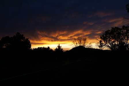
… I looked back, and saw this! Trust me, the picture doesn’t do it justice. The clouds simply lit up, as if they had been set on fire. It only lasted for minutes, and I was in the wrong place. I frantically tried to drive back to the Cathedral Rock Trailhead. By the time I arrived, the show was over. The sun was gone, the clouds were dark again.
I know that Sedona has some good sunsets, but this one really was extraordinary. Later that evening, I even overheard some local folks talking about how great it was. Oh well.
Note: This trip was first published in 2007.


No comments