
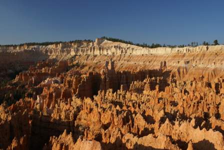
As I arrived back at Bryce Canyon early in the morning, I was happy to see that my suspicion from the previous night was correct: the early morning light really brings Bryce’s incredible landscape to life. The previous night I had only seen the amphitheater from the overlooks. Today, the plan involved a hike that would take me down into the middle of the hoodoos.
After looking at the park map, I chose a hike of reasonable length–about 3-4 miles. I started at the same viewpoint where I ended my visit, the previous night: Sunset Point. My final destination was Sunrise Point, on the rim about a half mile north. To get there, I’d take one side of the Navajo Loop trail down into the amphitheatre, then follow a connecting trail to the Queens Garden Trail, which climbs back up to Sunrise Point.
So, let the descent begin!

As soon as you drop below the rim, you immediately realize that anyone who doesn’t hike down from one of the viewpoints really is missing out on an amazing experience. From the overlooks, the sea of sculpted rock is a singularity–just one big thing that fills your view. But as you walk down, each of the thousands of hoodoos becomes an individual. You notice each one, rather than all of them at once.
As you’d probably guess, the Navajo Loop Trail offers two ways to descend. During my visit, the Wall Street section of the trail was closed, so I had no choice but to go the other way. After a couple of mild switchbacks, and a generally leisurely stroll downhill, you come upon this:

The trail loses a lot of elevation, very quickly here. These switchbacks are certainly more impressive than the more famous Walter’s Wiggles in Zion. I think they more closely resemble the Natural Entrance path to Carlsbad Caverns, since in both cases, you’re dropping down into a confined, dark space.
How they built the switchbacks without damaging much of the surrounding geology, I’ll never know. You’ll have time to ponder all of this, because it does take quite a while to make it to the bottom, and you’ll need to stop several times to give your legs a break.

As you reach the bottom, you’re in a tight canyon where the rock walls tower at least 100 feet or more on all sides. Remarkably, there are a few trees here…

… that grow straight up without a single branch, until they finally break free of the shady canyon walls.

While the morning sun lit up the rocks, the trail stayed in the shadows for quite a while. After hiking in 105o temperatures in Zion, the shady, high-altitude trails of Bryce Canyon were a welcome alternative.

I ran into a friendly squirrel…

… as I stopped here for a snack…

… and then another squirrel just a few minutes later.
Along the connecting trail, there weren’t as many hoodoos as before.

The scenery started getting interesting again, when the connector trail met up with the Queens Garden Trail.

The Queens Garden is a small patch of hoodoos and formations, that are especially colorful–ranging from white and pink to dark orange and red. To check out the Garden, follow a short dead-end trail off the main path.

As close as I could tell, this is the central figure in the Queens Garden–a rock that looks somewhat like a queen on a throne.

Look at those colors!
Once I left the Queens Garden, there wasn’t much left to do but climb back up to the rim, and after that, I had to leave Bryce Canyon and head back towards Zion. Since I was in no hurry to leave…

… I took a seat in the shady spot behind this hoodoo and relaxed for a while. While the hike was nice, just taking a few moments to soak it all in was even better.

On the climb back up, you’ll pass dozens more formations. I just happen to remember overhearing the leader of a passing tour group say that this hoodoo was called E.T. Rock, given its similar appearance to the famous alien. I wondered what it was called before 1982. Probably it was a good thing I wasn’t in the tour group, I would have annoyed them with such questions.

Near the rim, a different landscape jumps out at you. Instead of narrow canyons and rock walls, this looks more like badlands, with very few trees. It’s still beautiful, though.
Once back at the top, I made the return trip to Sunset Point along the rim trail. Back at the car…

… I checked the pedometer: 8,085 steps, or about 4 miles.
Note: This trip was first published in 2007.


No comments