
I only planned on driving half of the Bighorn Scenic Byway — from Shell to Burgess Junction. Even though I didn’t see the other half (from Burgess Junction east), I can’t imagine it’s any more dramatic or beautiful than the part I experienced.

Starting near the small community of Shell, the Bighorn Byway wastes no time in living up to its scenic status. The road drops down briefly, passing some ranch land and a few red hills…

… and even an out-of-place formation that looks like it was stolen from Sedona.

Then, the byway squeezes into the entrance to Shell Canyon. This is where it begins its climb. Signs along the roadside provide the names and dates of all the rock formations you’re passing through.
It was somewhere around this point that I realized I was almost definitely going to run out of gas. My car’s onboard computer estimated I had about 60 miles of gasoline remaining. Lovell, the next town, was at least 80 miles away. I hadn’t seen a gas station in the town of Shell, and if I turned around now, and backtracked all the way to Greybull, I would waste too much time. So, I kept going, uphill (which, of course, uses much more gas). The gas gauge made it tough to enjoy the rest of the scenery, but I tried.

The byway’s climb into the mountains is quite a thrill, and will probably cause a lot of anxiety to anyone who’s afraid of heights. In the picture above, you see Copman’s Tomb (elevation 8,875 feet), named for an early explorer who was so fascinated with Shell Canyon that he asked for his ashes to be scattered over the mountain.

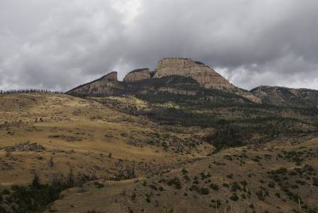
Across the canyon on your left, you’ll spot Pyramid Peak…

… and slightly further to the left, Sunlight Mesa, which ends at Elephant Head Rock.
Sorry, I didn’t get the name of this mountain peak.

After the dramatic climb ends, the byway tops out at 9,033 foot granite pass, then passes through wide-open fields where cattle (and occasionally, some wildlife) graze.
Just south of Burgess Junction, my fears of running out of gas were relieved. I found a lonely, old pump at the Passage Resort. Oh yes, it was expensive: $4.69 a gallon. I bought $5 of fuel, and watched my needle bounce up just enough, to ensure I’d arrive in Lovell, 52 miles away.
At Burgess Junction, I turned onto US Alt-14, for the drive west across Medicine Wheel Passage — yet another scenic byway, in an area that has more than its share of beautiful roads.
Note: This trip was first published in 2008.


No comments