
Just before Scenic Route 7 drops down from the hills, and leaves the Ozark National Forest behind, there are a couple of scenic viewpoints that provide a panorama of the valley below.
A plaque at the first overlook gives thanks to the workers of the Arkansas Farmers Union, who developed the roadside stop.

Another overlook, just a few minutes further north on Route 7, includes an observation tower and a gift shop.

The view is great, even without a climb up the tower…

… but if you do ascend to the top, you’ll also get a nice view of the scenic highway, just before the point where it drops down to the town of Jasper, Arkansas.
Jasper, Arkansas

I’m not certain the Ozark Cafe is really a famous landmark, but it did appear to be the only thing open in tiny Jasper. It’s also historic: dating back to 1909.
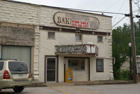
The town’s movie theater, the Buffalo, closed long ago. It looks like it served as a bakery or restaurant for a while, but now, the Buffalo is awaiting its next reincarnation.

Jasper has a couple of small motels, but I decided to drive on to Harrison for the night — which would put me in the perfect position to loop around through the Ozarks, and finally break away from Scenic Route 7.
Harrison: Day 6 Begins

In addition to having all the motels and grocery stores you’ll need to stock up the car, Harrison also has a nice, clean downtown, that’s worth a brief walk-around. The Boone County Courthouse (circa 1909) is at the center of it all.

Harrison’s old theater, the Lyric, was built 20 years after the courthouse. It’s now operated by the Ozark Arts Council. Before 1929, the town had another Lyric Theater, but it couldn’t accommodate “talkies”, so the second theater was built.

Harrison marks the northernmost point on my trip, but not the westernmost. On the way out of town, I located Arkansas Route 43…

… a country road that provides a relaxing drive through farmland. In many ways, I thought Route 43 (and the routes that followed on Day 6: 21, 16, and 23) was more scenic than the better-known Arkansas Route 7.

Route 43 eventually rises from the relatively flat farmlands, into the hills. This is the view at a viewpoint, after the road climbs towards Gaither Mountain. I’m not completely sure what hills you’re seeing in the distance, but I think they are (from the left) Pilot Mountain, Boat Mountain, Sulphur Mountain, and Fodderstack Mountain.
Beyond the viewpoint, there aren’t a lot of opportunities to see the surrounding lowlands, but I still got the feeling that I was driving on top of the world.
Drivelapse Video
Here’s a dash-cam time-lapse video of the drive from Harrison to my first stop of the day, Hide-out Hollow:


No comments