
If your goal is to experience the truly rural countryside of the Ozark Mountains, I can’t imagine a better place to drive than Routes 16 and 23. After hiking a couple some trails around the Buffalo River area (near Boxley and Fallsville), I was trying to decide whether to head back to Interstate 40 (via Arkansas Route 21), or extend my exploration a bit further. I chose to drive west on Route 16, then south on Route 23 — through an area where there are dozens of barns, but only a handful of homes and businesses.

Between Fallsville and Boston, Route 16 runs on top of a ridge. Even though there were no scenic overlooks, it still felt nice to be traveling slightly above the rest of the landscape. I only made one stop — to photograph this barn, which had some bales of hay inside, wrapped in vines.

I don’t know how many cities or towns there are named Boston, but this certainly must be the smallest.

Beyond Boston, Route 16 stayed between the hills, instead of on top of them. Of course, there were more barns…

… and more curves through heavily wooded areas, after I turned onto Route 23, headed south.

The communities of Cass and Paradise provided even more barns to photograph, as well as brilliant beds of lilies, which grow like weeds in this area.
Route 23 continues south, and crosses underneath Interstate 40. I considered calling it a day, and driving towards Little Rock for the night. But, I had one more destination on my list: Mt. Magazine, the highest point in Arkansas. So, I continued south into…
Ozark

Ozark is a small town, that feels bigger than it really is, thanks to a long day of driving through completely undeveloped areas. You can see more of the town on my drivelapse video (below). The only stop I made was on the south side of the Arkansas River.
Paris
South of the Ozark Bridge, turn on Route 309 for the drive to Paris, Arkansas, and on to Mt. Magazine.

Downtown Paris, Arkansas provides a good excuse to stretch your legs. It has a nice collection of downtown shops…

… which surround the Logan County Courthouse.
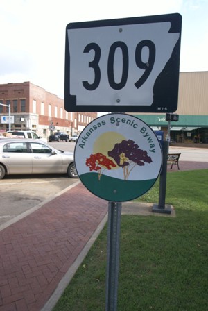
Route 309 is designated by the state as a scenic byway in Paris, but the National Forest’s “scenic” designation for the Mt. Magazine Scenic Byway doesn’t begin, until a few miles south of town.
Cove Lake

Shortly after Route 309 crosses into the Ozark National Forest, the road passes over the dam that forms Cove Lake. There’s a turnout here that lets you see the spillway…

… and provides a look eastward, over the lake.

As the road climbs towards Mt. Magazine, I stopped at a scenic overlook — but the view was blocked by trees, and wasn’t very exciting.
Drivelapse Video
Here’s the time-lapse, dash-cam video of the drive from St. Paul, Arkansas, through Ozark…
… and here’s the drive from Paris to Mt. Magazine State Park:


No comments