
After visiting Cheaha State Park, Alabama’s highest point, I had one goal in mind: drive more than 500 miles before the end of the day, to get home to Florida. The final day of a trip is never fun, but it’s even worse when there’s a whole lot of highway to cover. So, I plotted a course: south on Route 49, then east on US 280 to Interstate 75, which would take me the rest of the way to Tampa. Any stops along the way would have to be brief. Fortunately, my first stop in Lineville, Alabama, didn’t require much time.
Lineville, Alabama

Lineville’s main street is a quiet place. Most of the town’s storefronts are empty.

The only Lineville landmark that caught my eye was this historic plaque, at the corner of Routes 9 and 49. The sign explains that, on this spot in 1838, “Lundie’s Crossroads” was settled here. The name changed in 1856 to “County Line”, because Lineville used to straddle the border between Talladega and Randolph Counties (nowadays, it’s in the middle of Clay County, Alabama). Lineville received its current name in 1870.
Route 49 passes across miles and miles of rural landscape as it heads south.
Horseshoe Bend Military Park

Route 49 crosses over the Tallapoosa River at Horseshoe Bend Military Park, the site of a battle in 1814, that pitted the U.S. Army against the Upper Creek Indians.
There’s a small picnic area next to the Tallapoosa River, underneath the Route 49 overpass. Next to the new bridge…

… you can still see the support columns from the Miller Covered Bridge — the longest covered bridge in America before it collapsed in 1963.
Continuing down Route 49…

… you’ll see some old, abandoned homes like this one. Near Dadeville, Alabama, Route 49 ends at US 280.
I drove on into Georgia, stopping only to grab some lunch and fill the gas tank. As I approached Richland…
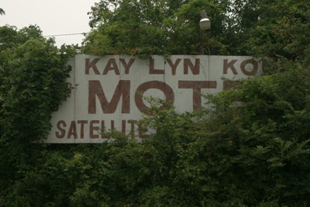
… an overgrown billboard for the Kay Lyn Kourt Motel caught my attention.
Richland, Georgia

You don’t have to go far from downtown Richland, Georgia, to realize this is a farming town. An old metal shed with a ghost sign is just blocks away…

… from the line-up of storefronts on Broad Street.

There are a tangle of railroad tracks around town, so it’s no surprise that there’s an old railroad station here.

No doubt, downtown Richland is a lot more lively on the second weekend in November, during PigFest. A strange, round brick chimney-looking thing in the middle of town advertises the event.
Drivelapse Video
Here’s the time-lapse dash-cam video of my drive from Opelika, Alabama to Richland, Georgia via US 280:


No comments