
Okay, I’ll admit it. Up until the middle of Day 3, I wasn’t very impressed with Vermont’s offering of fall colors. I was beginning to wonder if this was an “off year”, or perhaps I missed the peak. Maybe, I pondered, Vermont isn’t all it’s cracked up to be in the fall. Then…

… I drove through Smuggler’s Notch. This was, by far, the most beautiful place I visited in all of Vermont. The leaves were spectacular — mostly yellows and oranges. The narrow pass forces Route 108 to squeeze down to about one-and-a-half lanes, and it gets even narrower as the road twists around huge boulders.

Sheer rock cliffs tower above everything in Smuggler’s Notch. To the east is Spruce Peak (3,323 feet/1,012 meters), and to the west is the chain of peaks that make up Mount Mansfield (Vermont’s highest mountain, at 4,380 feet/1,335 meters). Smuggler’s Notch Pass is at 2,240 feet (682 meters).

There is a small parking area near the pass, and more parking is available at the side of the road, wherever you can squeeze in.

You’ll want to spend a few minutes walking along the road, especially if you’re visiting in autumn.

At any point, you can wander into the woods, where huge chunks of rock jut up from the ground. Kids will have a lot of fun playing on the boulders here.


Just after crossing the notch, headed south, I stopped again to check out a pair of waterfalls. The one on the left side of the road is quite beautiful. Even though it’s not especially high, it does take quite a few tumbles as it rolls down the hillside.
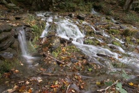
I don’t know this waterfall’s name, but it must be pretty well known. A camera crew had rigged up cables over the falls, so that they could shoot video of it from above.

Across the street, another small stream comes tumbling down. The yellow fall leaves were the most brilliant part of this waterfall, but I’m sure it would be nice in summer, as well.
Drivelapse Video
Check out this dash-cam, time-lapse video of the drive from Jericho to Cambridge on Route 15, then Route 108 south through Smugglers Notch:


No comments