
Just to the south of Smuggler’s Notch, you have the chance to climb Vermont’s highest mountain, and best of all, your car can do all the work. The Mount Mansfield Auto Road gains nearly a half-mile of elevation in its 4.5 mile trip up the hill. The road ends just shy of Mount Mansfield’s highest point (4,395 feet/1,339 meters).

Almost all of the Mt. Mansfield Auto Road is unpaved, and most of it is only one-lane wide. That isn’t a problem, really, since everyone on the road will probably be driving slowly, and enjoying the scenery.

There aren’t many long-range views on the way up, but in fall, you won’t mind. Branches covered with yellow and orange leaves extend over the road. It seemed like I wanted to stop and take a picture, every time I rounded a corner.

This side road is off-limits to vehicles, but would probably make for a pretty stroll, if you have the time.

About halfway up Mt. Mansfield, you’ll pass the Mountain Chapel. This small church is open on Sunday afternoons for a prayer service at 2 p.m., and it can be reserved for weddings or memorials at other times. The doors were locked when I visited.

During the winter months, the Mt. Mansfield Auto Road serves as a long, easy route for downhill skiers. I’m guessing it looks a lot different then.

At the parking area (at 3,850 feet/1,173 meters), you get a good view to the east. But the view only gets better, when you start hiking along the ridge (scroll down to read about the hike).
Drivelapse Video
Here’s a dash-cam, time-lapse video of the drive up and down Mt. Mansfield Auto Road:
Hiking Atop Mount Mansfield

The Auto Road ends just below Mt. Mansfield’s “nose”. Supposedly, if you view the mountain from a distance, you can see the profile of a face. From the start of the trail, the nose looks pretty high, but it’s not the highest spot on the ridge. While the nose tops out at 4,062 feet, the chin is the main attraction, at 4,393 feet, Vermont’s highest point.
An easy trail runs along the top of the ridge from the nose to the chin. It’s about 1.3 miles, one way, but it does involve some up’s and down’s, so it can be a bit more tiring than you’d expect from a short trail.

The trail begins with this boardwalk, through a forest of stunted trees. Not long after, the trail enters arctic tundra — one of only two or three places in Vermont where this kind of ecosystem exists.
Click on the image to view a larger version.
The view from here is already better than what you could see from the parking lot, and it only gets better.

After you’ve hiked a short distance down the trail, turn around and look at where you’ve been. The “nose” is home to the mountain’s radio towers.

Looking north, it’s obvious where we’re headed. The chin — the top of Mount Mansfield — is clearly the goal of this hike.

Even before you reach the mountain’s highest point, you’ll have a great view to the east…

… as you look down at the Stowe Mountain Resort.

It looked like every tree in this valley was at the peak of fall color on October 4, 2010!

The final climb crosses over the mountain’s sheer rock face. Follow the painted-on white blazes…

… and this boardwalk across the fragile tundra…

… then make the final climb up Mt. Mansfield’s chin.

At the top, you’ll want to sit and relax for a while…

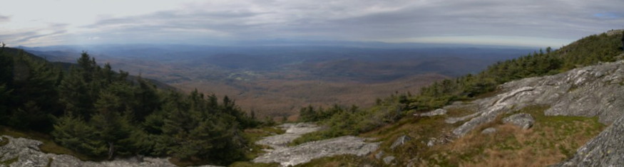
Click on the image to view a larger version.
…and take in the panorama. Obviously, since you’re at the top of Vermont, there’s something to see in every direction, with nothing blocking your view.

Looking south, beyond the nose, Vermont’s peaks line up, one after another. Camel’s Hump (Vermont’s third-highest mountain) is one of the most recognizable, right in the middle of the photo.

The hike down allows you to look in a different direction — to the south — and there’s a lot to see.

From this vantage point, you can truly appreciate the rough topography of the green mountains.

I’m fairly certain that you’re once again looking at Camel’s Hump — the distinctive peak in the middle of the photo. It’s about 20 miles away.

You’re almost back to the parking area, when you pass the transmitter tower for WCAX, channel 3.


No comments