
This time, I wasn’t going to screw it up. This time, I was headed straight to the top of Dorr Mountain, Mount Desert Island’s second highest point. This time, I didn’t have time to make another mistake.
On my first climb towards the peak of Dorr Mountain, I took a wrong turn. A day later, it was almost time for me to leave Acadia National Park, and head back down the coast, on the final full day of my vacation. I had to leave the park by early afternoon. I only had about three hours before my self-imposed departure deadline. I didn’t want to leave Acadia with my failure looming over me. So, I devoted those final three hours to making things right.

On the previous attempt, I took a circuitous route up Dorr Mountain. This time, I decided to stick to Emery Path all the way. Emery Path begins near Sieur de Monts Spring, behind the nature center and the Wild Gardens of Acadia. It’s the only path in the area that’s easy to find. Finding it, though, will be the only easy part.

Emery Path does a whole lot of climbing. It’s an uphill slog, almost the entire way, but it’s a well-constructed trail, with lots of rocky steps.

Those steps lead to some fantastic views of Mount Desert Island’s Great Meadow — the wide valley between Dorr Mountain and Bar Harbor. Look for this brilliant red tree, and many others, if you visit in early October.

Amid the steps, I found a good place to sit for a moment, and take a break. There’s a small waterfall behind me, but the better view was looking out, at the steps and the scenery beyond.

The trail is, at times, a “shelf”, with a rock wall on one side, and a steep drop on the other. If you’re afraid of heights, you might not enjoy this part.

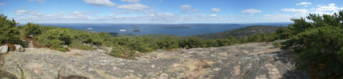
You will, however, enjoy this view. Bar Harbor is somewhere out there in the distance.
On the previous day’s hike, I had taken Homans Path as an alternative to Emery. Homans Path looped further out, but eventually reconnected with Emery. Once the trails met, I was retracing my steps — giving me plenty of time to look for the spot where I made my mistake.

These steps look familiar. I took an almost identical picture, two days in a row.

I sighed deeply when I arrived at this sign. It marks the end of Emery Path, the beginning of Schiff Path and Kurt Diederichs Climb. It’s also the spot where I made the previous day’s mistake. Surveying the area, I can see how I missed it. Schiff Path (the area on the left side of the picture) barely looks like a path at all. The previous day, I had walked right by it, then started downhill, without a second thought.
This time, I headed in the right direction, and followed Schiff Path.

I had hoped that most of the climbing was behind me, but Schiff continued uphill, with more stairs to climb. In a few spots, this trail was under construction (as of 2010), which made it a little more difficult to navigate.

Schiff Path passed by some great fall foliage, adding color to the rocks.

This sign marks the start of the Ladder Trail. It will take you downhill in a hurry, with the help of some rungs, or ladders, fastened into the rock. Since it’s only 6/10 of a mile from the peak of Dorr Mountain, it would make a good alternative for the return trip.

When you pass through this “gateway”, you’re getting to the most enjoyable part of the trail. Lots of exposed rock lies ahead.

Click on the image to see a larger version.
Near the top of Dorr Mountain, the trees are fewer and farther between, which means you’ll enjoy great views, looking east.

This part of the trail is marked by cairns (piles of rock), as well as an occasional painted blaze.

Schiff Path ends at the North Ridge Trail (which as the name suggests, leads down the ridgeline of the north side of Dorr Mountain). Turn left at this signpost…

… and you’re almost there. It’s only about 1/10 of a mile further uphill, to reach the peak of Dorr Mountain.

Dorr Mountain would be more impressive, if it wasn’t for its bigger brother, Cadillac Mountain, behind it. From here, you’re close enough to see the crowds of people that took the road up to the top of Cadillac Mountain. You could hike from here to there, if you’re not in the mood to finish up your hike. It’s probably less than a mile away, though I don’t know the exact distance (via the Cadillac-Dorr connector and Gorge Path).

The pile of rocks atop Dorr Mountain anchors this marker in place. From here, you can choose to follow the North or South Ridge trail.
Click on the image to see a larger version.
The view from the peak of Dorr Mountain is just as splendid as those I had seen on the way up. It was tough to enjoy myself at the top of Dorr, though. Once I had reached the exposed rock along the ridge, there were no trees to block the wind, and it was brutal!

I couldn’t tolerate the breeze for more than a few minutes. Plus, I had a deadline to meet. So, my final conquest in Acadia was brief, with only a moment to enjoy the accomplishment.

For the trip back down the hill, I chose the Dorr North Rim trail. It starts out easy enough, following the bare-rock ridgeline as it slants downward.

But before long, the trail entered the trees. This thick woods was unrelenting, and so was the steep grade. Because the trail was so rocky, I hopped from one boulder to another, then another, and another. It seemed to take a very long time, and there wasn’t much to see along the way.

Occasionally, I would find a few colorful trees, and enough light poking through the canopy to make them picture-worthy.

I found this clearing…

… just before coming across the Hemlock Trail. Heading straight here would have taken me to the top of 407-foot (125 m) Kebo Mountain. Instead, I turned right, heading east…

… and continuing downhill. Part of the way, the Hemlock Trail passes through this dark and spooky forest.

Hemlock Trail ends without providing you a clue of exactly where you are. I made another right, and hoped I was headed in the correct direction. This wide, gravel path is Hemlock Road. It’s similar to the park’s Carriage Roads, though I don’t believe it’s tied into that network. Hemlock Road is an easy, relaxing walk, and plenty of people were on the trail, which gave me some reassurance that I was headed towards civilization, after that long, disorienting hike through the woods.

I finally figured out where I was, when I reached Homans Path and Jesup Path, two trails I had followed on the previous day, when I made the climb halfway up Dorr. From this point, the Sieur de Monts area, and my car, were just a tenth of a mile away.
Emery Path – 1/2 mile
Schiff Path – 9/10 mile
From the end of Schiff to the top of Dorr – 1/10 mile
Dorr North Ridge Trail – 8/10 mile
Hemlock Path & Hemlock Road – 6/10
… for a total of just over 3 miles round-trip.


No comments