
In one of the most, if not the most, thinly-populated areas of Utah, there’s a huge jumble of geology called the San Rafael Swell: a 70-by-45 mile dome of sandstone, shale, and limestone. Inside the swell are washes, canyons, plateaus and jagged ridges — certainly one of the most impressive landscapes in the country. Interstate 70 cuts through the middle of the Swell, but to get a better taste of it, you need to get your car a little bit dusty.

Buckhorn Draw Road (or Buckhorn Wash Road) is an easy-to-drive, well-maintained dirt road that cuts through the northern half of the Swell. It starts near Castle Dale on Utah Route 10, and heads southeast, meeting up with I-70 at exit 131. Of course, you can drive it the opposite direction as well.
Shortly after you turn onto the dirt road, you’ll see this sign (above). It’s the first confirmation that you’re headed in the right direction. If you don’t see it, you’re probably on the wrong road.

The first part of Buckhorn Draw Road follows the same path as the old Spanish Trail, which ran from Santa Fe to Los Angeles, with a big curve northward through this part of Utah. You’ll see a few markers along the way.

The first few miles of the road passes across some rolling ranchland, with just enough twists and turns to keep you from getting bored.

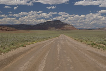
Not long after you’ve started down Buckhorn Draw Road, the road crests a ridge, giving you a great look at the landscape, and the road that lies ahead.

Click the image to see a larger version.
After heading down from the ridge…

… I found a side-road that led to a pile of rocks.

It was worth a picture or two, but the side road was much rougher and steeper than the main road. I made it back safely, but it made me realize that it’s best to stick to the main road out here.

Occasionally you’ll pass a sign, identifying which layer of rock you’re passing through. In this case, it’s Entrada Sandstone — which geologists say dates back to the Jurassic period, 140 to 180 million years ago.
Turnoff to Wedge Overlook
There’s a well-marked intersection where a well-maintained side road splits off from Buckhorn Wash Road. Make the turn, and drive across the desolate plains for about six miles, and you’ll abruptly come upon a natural wonder so impressive, you’ll be shocked that almost no one knows about it.
Drivelapse Video
Here’s a time-lapse dash-cam video of the drive over Buckhorn Wash Road, into the San Rafael Swell, including the Wedge:


No comments