
Just about every National Park has some sort of scenic drive, viewpoints, and hiking trails. Acadia offers something else. The park is criss-crossed with a network of “Carriage Roads” — pathways built for non-motorized vehicles, that are perfect for biking or walking. There are 45 miles of Carriage Roads on Mount Desert Island.

I decided to start my adventure on Acadia’s Carriage Roads at the park’s Visitor Center, which is about a mile northwest of Bar Harbor. I rented my bicycle in town — and I should have caught a bus from the village green to the Visitor Center. Instead, I decided to pedal my way up to the starting point. The Visitor Center is sharply uphill from town, and it was a lung-straining challenge to get there.

At the far end of the parking lot at the Visitor Center, the Carriage Road begins. Once again, I was facing another uphill climb…

… for the first half-mile or so. A park ranger had advised me that this steep climb wouldn’t be as bad as the ride up from Bar Harbor (which was true).
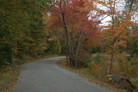
Immediately, I could see the allure of these paths. The road was lined with trees, many of which were starting to turn with autumn colors. Enough leaves had already fallen to begin covering the path. This was a quintessential New England fall scene.

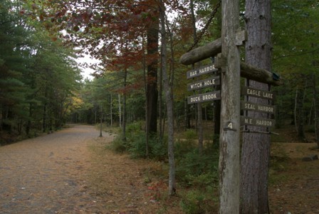
Every intersection along the Carriage Roads is marked with a numbered signpost. Even though you could figure out where you are headed based on the sign, it’s almost essential that you get a map of the Carriage Roads from the Visitor Center.
At signpost #1, I decided to take a left, and head up a .9 mile stretch, which would eventually loop around to Witch Hole Pond. “Up” is the key word in that last sentence — the section of road from signpost #1 to #3 once again challenged my legs, which were more accustomed to cycling in Florida. But it was worth it…

… since this section of the road peaked at a nice view of the harbor.

Following the viewpoint, I enjoyed a brief roll downhill to signpost #3, then headed towards Witch Hole Pond.

Witch Hole Pond might have been a little more beautiful on a sunny day. Then again, just about everything always is. But I still took a moment to enjoy the view of Witch Hole before hitting signpost #2…

… and turning south for an easy 1.1 mile stretch towards signpost #4.

Every once in a while, the sun would find its way through the clouds, and I’d get a brief chance to take a nice picture. Such an opportunity lasted only seconds, so I scrambled to shoot one direction…

… then the other.

The trail passes by a couple more small ponds, which are studded with dead-looking trees…
… before reaching signpost #4. It’s another 1.1 mile stretch to signpost #6, and if I recall correctly, it wasn’t very challenging.
Just before reaching the northern edge of Eagle Lake, the Carriage Road passes underneath Maine Route 233. There’s a parking area here, and a bus stop, so this would make a good place to start a walk or ride on the Carriage Roads. There’s also a nice stone bridge over the path — but it was under reconstruction during my visit, so I didn’t get a picture of it.

Even though the weather wasn’t perfect, there were a lot of people hanging out at Eagle Lake. It’s a 6-mile loop around the lake — enough for an easy but lengthy hike, or a decent bike ride. You could also hike from here to Bubble Pond, just a little more than 2 miles away, and catch another park bus there.
The fall colors were quite beautiful in this spot…

… even though the lake looked grey. In the distance, you can see one of the Bubbles.

I decided to take the long way around Eagle Lake, looping around the east side (2.1 miles)…

… towards signpost #7…

… then another 1.8 miles to signposts #8 and #10. Between #10 and #14, it’s a 2-mile stretch, but halfway there…

… you’re treated to a view of this roadside waterfall cascade, which tumbles under the road beneath another hand-cut stone arch bridge.

Much of the remaining mile is downhill. I stopped along a section of road that was lined with coping stones — cut boulders that serve as guard rails, affectionately known as “Rockefeller’s teeth”.

Jordan Pond Area
The Jordan Pond signpost is #14, and it’s just a short distance uphill from Jordan Pond House (more on that in a moment). I zipped by signpost #14, knowing I would have to pedal back up to it, in order to continue my ride.

When the road bottoms out at the edge of Jordan Pond, there’s another stone bridge that carries the Carriage Road across the lake’s outlet.

Even though this is one of the smaller stone bridges in the park, it’s probably one of the most photographed, since a lot of people stop at Jordan Pond House, then walk down to the lake.

There’s a nature trail here that circles the entire lake…

… giving you plenty of opportunities to see the view of the almost-erotic “Bubbles”.

Just slightly up the hill from the lake, Jordan Pond House offers sit-down meals, an expansive gift shop, and restrooms. I had remembered to bring a bottle of water with me on my ride, but had forgotten any snacks. Thankfully, the gift shop was stocked with sandwiches and drinks — perfect for a picnic on that expansive green lawn.
At Jordan Pond, I had to make a choice. I had been biking for 3 hours, and was getting tired. But at the same time, I had rented the bike for the entire day, and given the cloudy weather, I didn’t have any other plans for filling the rest of the afternoon. I could catch a bus and head back to Bar Harbor, or extend my ride to Northeast Harbor and catch a bus from there.
I decided I wasn’t ready to be done with the Carriage Roads, just yet. And in retrospect, that was probably a bad decision, because of one thing that, at the time, I didn’t know: it was about to start raining.

I pedaled back up to signpost #14, then took a left towards signpost #21. Unfortunately, more uphill climbs awaited. I hadn’t talked about this part of the ride with a park ranger, because I didn’t think I would get this far. I didn’t really have a plan when I started out. So, at each signpost, I would pull out my map and hope, and pray, that the direction I wanted was downhill. Most of the time, it wasn’t.

There were some nice views along this part of the Carriage Road — including this shot, taken somewhere between signpost #21 and #20. The road heads into a hollow here, then emerges on the side of that mountain.

Another nice stone bridge marks the curve at the deepest part of the hollow. I would have loved to have taken more pictures of this graceful, curved bridge, but by this time it was somewhere between a drizzle and a downpour.
Because of the rain, I gave up on taking pictures of signposts. Somewhere along the way, I passed #20, #19, and #18.

I’m not even sure where this bridge was located. I thought about trying to get a better picture of it, but the rain was discouraging me — and so was my fatigue.
The Carriage Road eventually emerged from the woods, and connected with Maine Routes 3 and 198. There is a beautiful “Gate House” here — a distinctively designed stone lodge and gate, which served as a welcome to the Carriage Road System. There is one here, and another near Jordan Pond — and I didn’t take a picture of either of them. Sorry.
In the summer months, one of the park’s shuttle busses stops at the gate house. But when school starts in the fall, many of the bus drivers have to return to their school bus routes, and the shuttle system cuts back on its routes. That meant I had to ride another mile or so on Route 3 to the town of Northeast Harbor. This was certainly my least favorite part of the ride. It was cold, rainy, and dirty road water sprayed up on me as I dodged traffic. Fortunately, I arrived at the bus stop at 3 p.m., just before the bus to Bar Harbor was scheduled to depart. If I had missed the bus, I probably would have spent a half hour exploring Northeast Harbor, and I would have some nice pictures of it for you. Once again, sorry. Just a little.


No comments