
When you’re in Jasper, and you’re looking for somewhere scenic to drive, you have three choices. The highways form a letter “T” — you can either take the Icefields Parkway south, or the Yellowhead Highway (Route 16) east or west. As Day 8 came to a close, I decided to drive west, towards British Columbia and Mount Robson Park, just to see what I could see.

Highway 16 is a beautiful drive, as you leave Jasper and head over the continental divide into British Columbia. But there were a few things that made it less than enjoyable for me. For starters, there are almost no turnouts along the road, which is surprising, given the scenic nature of the area. Also, Highway 16 is mostly 2-lane, but it’s a very busy highway, that carries a lot of truck traffic. Forget about going the speed limit — your only choice is to move along with everyone else. This makes pulling off to take pictures especially dangerous. And to top it all off, I didn’t see many places that were especially photo-worthy. It’s a beautiful area overall, but there weren’t many specific things to see.
At the time, I thought the mountain you see in the photo above might have been Mount Robson — the highest point in the Canadian Rockies, at 3,954 meters (12,972 feet). But it turns out, the mountain I photographed isn’t nearly big enough. This photo shows several peaks, including Yellowhead Mountain, Bingley Peak and Leather Peak. Leather Peak, on the right, is on the BC/Alberta Provincial border, while the other two summits are in British Columbia.
So, it’s a nice picture, but not the mountain I intended to photograph. The best place to take a picture of Mount Robson, I believe, is to drive to the other entrance to Mount Robson Park, where you’ll find its iconic sign in front of the big hill.

On the eastern end of the park, the mountain goat-topped sign is not nearly as photogenic.
If I had driven about 10 kilometers further, I would have come upon Moose Lake. Highway 16 runs alongside the lake for a few kilometers. And if I had driven about 45 kilometers further, I would have reached the other end of the park, and a nice view of Mount Robson.
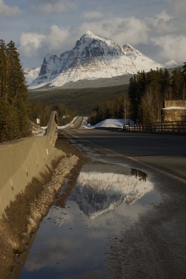
I guess I should have driven a bit further, but I didn’t. I turned around and headed back to Jasper. Along the way, I stopped at Fraser River (proclaimed to be the “world’s greatest salmon river”, by a roadside sign) for this picture of Mount Fitzwilliam (elevation 2,907 meters, 9,538 feet). A highway puddle isn’t quite as stunning as a pristine lake, but it still provided a nice reflection.
And the good news is, I found a nice place to watch the mountains glow in the setting sun: once back in Jasper, I headed south along the Icefields Parkway.
Drivelapse Video
Here’s the time-lapse, dash-cam video of the drive from Mount Robson Park, back to Jasper, then down the Icefields Parkway a short distance:


No comments