
What better place to start your visit to Mount Rainier National Park, than at Sunrise. That’s not just a time of day — it’s a location, and a suggestion for when you should visit here. The Sunrise area is located on Rainier’s east side, which means you can expect the mountain to be beautifully lit during the first few hours of the day. You can hike here anytime, and many of the surrounding hills are most beautiful in the afternoon, but the morning is Rainier’s time to shine.
There are enough trails at Sunrise to fill several days of hiking. I’ll tell you about the longer ones on the following pages. For now, let’s assume you just want to spend a few hours here, and hike only a mile or two.

You’ll want to start your visit to Sunrise here, at the day lodge, which offers a gift shop and restaurant. There’s also another building, just a few hundred feet away, to the left of this one, that houses a visitor center.

Most of the trails at Sunrise begin near the restrooms, in between the two big buildings. Watch for this sign to point you in the right direction. When you get to the trailhead, you will walk uphill for about 100 feet, then you’ll come to a Y.

Either way you go, you’ll be headed towards the top of Sourdough Ridge, and you can easily make a loop at the top, then come back down the other side of the Y. The entire route will be about 1.4 miles. On this visit (the first of several — I’ll talk about the others later on this page), I decided to go right, towards Dege Peak.

This was my first visit to Rainier, in August, 2011 (the second visit was one month later). I must have arrived at the peak time for wildflowers, because the entire slope of Sourdough Ridge was bursting with color…

… and the bees couldn’t have been happier.

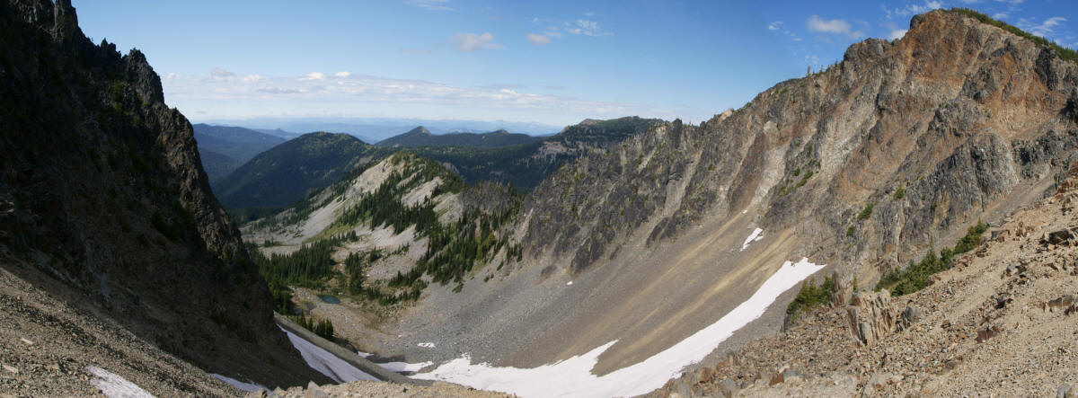
Lupine added purple patches to the hillside. This view looks towards the southeast, and the road that leads up to the Sunrise area is down there, somewhere.
Click on the image for a larger version.
When you get to the top of Sourdough Ridge, there are several places to peek over to the north side. The view reveals some dramatic valleys, as you gaze out into the Huckleberry Basin.

On this visit, I turned left at the top of the Y, and continued around the Sourdough Ridge loop. The trail runs near the top of the ridge, giving occasional peeks over the top of it, to the north. Of course, that view doesn’t seem as important now, that you’re facing west, and constantly staring at the main attraction, Mount Rainier. (As you can see, I wasn’t visiting Sunrise at sunrise, it was later in the day, and the mountain wasn’t in the best light.)

Jagged peaks stand in front of more jagged peaks, as you look south.

Another opportunity to look north comes at the next junction, where you can decide to go back down the other side of the Y, or continue along the ridge towards the area’s other great trails (keep reading!). On this visit, I headed downhill…

… and spotted more great wildflowers…

… and other plants. It’s hard to believe how much this area changed, by the time I made my next visit, a month later.
Second Visit to Sunrise
During my week-long stay at Mount Rainier in late September, 2011, I discovered that the weather in Washington is not always perfect. I had lucked out the previous month, and both days I spent at Rainier had been incredibly beautiful. This time, I wasn’t as lucky — and my first two days were soggy and grey. When I awoke on the third day, and saw more clouds and rain, I bailed out, and drove to Yakima, just to see some sun. On the return, as I got closer to Rainier, I was once again headed into gloom.
But I decided to drive up to Sunrise, anyhow. And it’s a good thing I did, because by the time I arrived, the clouds were breaking up, and occasional patches of blue sky appeared. I only had a couple of hours of daylight remaining, so I decided to take a quick hike up to the top of Sourdough Ridge.

Here I was, once again, at the same trailhead as a month ago, except this time…

… the wildflowers were much harder to spot. Gone were the endless fields of lupine. Now, I had to be content with an occasional patch of half-wilted blooms.
This time, I hiked up the left side of the Y, the same trail I would hike the next morning (keep reading!). At the top…

… there was a nice view towards Dege Peak (I’m not sure if that’s it, it might be the next mountain in that direction, hidden by clouds in this picture).

I only hiked for about 15 minutes towards Frozen Lake, enough time to get, perhaps, a third of the way there. Then I stopped and looked north, towards the Huckleberry Basin.

As you can see, I didn’t have a lot of daylight remaining. Oh, and did I mention it was cold? Upon returning to my car, the thermometer said 36 degrees Fahrenheit (2 degrees Celsius).
Before I left my car, I pointed my Drivelapse camera towards the day lodge, and let it roll. Here’s what it recorded, an hour of video boiled down to 45 seconds:
The clouds would clear out by the next morning, but not before they dusted the area with some snow.
Third Visit to Sunrise
About 14 hours later, I was back. I didn’t see the actual sunrise at Sunrise — instead I opted for the view from Chinook Pass. I made it to Sunrise about an hour after the day had begun, and what a day! Perfectly blue skies, not a cloud anywhere…

… and a fresh dusting of snow. I left behind an advertisement for the website, then headed up that familiar path, once again, taking a left at the Y, and heading towards Frozen Lake, which is about 1.5 miles from the parking area.

This is what Sunrise is all about! This early in the morning, Mount Rainier is beautifully lit. Add a cloudless sky, and a fresh dusting of snow, and it’s impossible to take your eyes off this beautiful mountain. Best of all, you don’t have to, since the trail to Frozen Lake heads west, so Rainier is always just ahead of you, and to your left.

If you do glance to your right, you’ll see some new perspectives of the hills that lie to the north, towards the Huckleberry Basin. Most of the time, though, the view to the north is hidden…

… as the trail skirts the southern edge of the ridge.

At this split in the trail, you can head towards Forest Lake. There’s a campground next to the small lake, about 1.9 miles away, and 1,000 feet downhill. I don’t think it’s one of the most desirable trails in this area, so I skipped it on this visit.

The area around Frozen Lake comes into view, with about a half mile to go. Most of that half-mile cuts across a scree slope (you can see it in the distance).

It’s a remarkable feat of engineering that the park was able to build a trail across this loose rock. Somehow, workers carved out a shelf, creating a wall with the rock. It must have been quite a job.

Looking back, the Paradise parking lot and day lodge are somewhere in this direction. I took this picture late in the day, as my aching feet finished up 11+ miles of hiking.
But enough about the end of the day. Let’s jump back to the beginning, as I trudged along through the freshly fallen snow.

I was the first human to travel the trail that day, but not the first creature. I came upon these tracks (that looked to be dog-sized), and followed them all the way to the lake. I thought it was interesting that the tracks followed the trail, even in places where, for an animal, a shortcut would have made more sense.

Almost at Frozen Lake now, the trail makes a sharp turn to the left, and climbs a small hill, providing a good look back at where I’d been. Still no other humans in sight.

Frozen Lake holds clear, blue water, but because it’s the water supply for the facilities at Sunrise, it’s fenced off. That lack of access would make Frozen Lake a disappointment, if it was your only destination. The good news is, the lake is just one attraction at this spot.

The best thing about a hike to Frozen Lake is the view. Mount Rainier continues to captivate your attention here, although it’s slightly obscured by Burroughs Mountain. No worries, you can just climb to the top of Burroughs Mountain for a better view. The Burroughs Mountain Trail splits off to the left, at the big junction near Frozen Lake. Go straight, and you’re on the Wonderland Trail. Turn right, and you’re headed to the old fire lookout atop Mount Fremont.
As I mentioned, my 11+ mile hiking day was just beginning, and I ended up sampling all three of those trails. My first choice was a bitterly cold hike up Mount Fremont.


No comments