
One of the best ways to enjoy southern Alberta is to get off the main road between Pincher Creek and Waterton Lakes, and explore the backroads at the foot of the mountains. Some call these mountains, immediately north of Waterton Park, the “Castle Special Place”. Numerous dirt roads criss-cross the area, passing ranches and natural gas facilities. While there aren’t many (or maybe any) established attractions, the area is a photographer’s dream.
My Visit
As I left Waterton Lakes Park, I was a little disappointed in how my day was shaping up. The park was nice, but not extraordinary. There were some clouds hanging around, and nothing looked quite as spectacular as I had hoped. I started to wonder if my day was almost over. It was early evening, but still hours before the late June sun would hit the horizon.
I started driving up Route 6 towards my overnight stop in Pincher Creek – a town I was familiar with. A couple of years earlier, I had visited the area in late winter. I know, that’s a strange time to go to Alberta. I spent three nights in Pincher Creek, and one of those days in Waterton, trudging around in the snow.
Back in 2012, I had an incredible experience on the drive back to Pincher Creek. Fog started rolling in, and instead of driving straight into it, I turned off Route 6 onto some side-roads to the west, and skirted the edge of the clouds.

It was an extraordinary evening, when I managed to get pictures like this…

… and this.
So this time, as I drove north, I detoured once again, selecting a dirt road at random…
… and headed towards the mountains along the Continental Divide. These stately mountains lie between Waterton Lakes National Park and Highway 3 at Crowsnest Pass. This area is not covered by any national park. Some call it the Castle Special Place, due to Castle Peak, and the Castle Valley which runs through part of the area. A movement is afoot to give this area more protection and respect — something that seems like quite a nice idea to me, a casual visitor from a foreign land.

I could drive around on these roads all day. And that’s exactly how I filled the rest of my evening. I took one road after another, drove it as far as I could…

… past ranch land…

… and to the foothills of the mountains, where the road would suddenly end, or a gate would block my path. Then I’d turn around and try another route.

Just like that previous day, a couple of years earlier, I was flirting with some extraordinary weather. Occasionally I’d end up in rain, and at other times, I’d be far enough from it to enjoy a rainbow.
There are numerous gravel roads in this area, but only one paved road, as far as I know. It’s known as Shell Road, or Township Road 43, and it parallels the railroad tracks out to the Shell gas plant. Go beyond the industrial site, and the road turns to gravel…

… and eventually leads to this idyllic scene. The lake is actually very small, maybe just a few hundred feet across, but it provided a grand reflection of the mountains to the west.
Just beyond the lake…

… I reached a locked gate, and this sign, which is about the most bizarre thing I’d ever expect to see in the middle of the Rocky Mountain wilderness. This area is, however, heavily industrialized by the natural gas industry, so it makes sense that some scuba-like protection may be necessary at some of these sites. Another sign told hikers how to react if they detected a gas or sulfur smell.

A few more side-roads led to beautiful dead-ends. There are some hiking routes in this area, but I don’t know much about them.

That rainbow just wouldn’t go away, so I tried to find a good spot to photograph it.

Since the mountains were to my west and south, and the sun was headed towards the western sky, it wasn’t easy to get the rainbow and the mountains in the same shot.

Just before one dead-end, I came across a few horses, who have no idea just how good a view they have.

This road is more primitive than many of the others that I traveled. I only tried my luck on it, just far enough to get the picture.
Eventually, I made some progress towards Pincher Creek, but soon I detoured again.

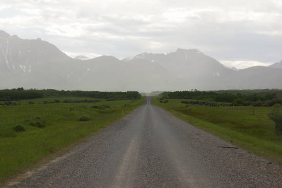
This beautiful dirt road beckons you to drive it, does it not? This is Township Road 60, just southwest of Pincher Creek, looking west towards the Continental Divide.

The clouds and light were simply magical.

Finally, I ended up on Alberta Route 507, which heads west from Pincher Creek, then north to Highway 3, the Crowsnest Highway. I was getting further from the mountains now, but I had not choice. At some point, I had to get to my motel and call it a night. Although, as you’ll see on my Pincher Creek page, I was distracted one more time, by a fantastic sunset, just outside of town.
The Bottom Line
The next time I’m in southern Alberta, I’m going to reserve an entire day, just to explore the rural roads that wander around the foothills and prairie. If you’re a photographer who enjoys dramatic mountains, rolling hills, endless dirt roads, and dramatic clouds, you’ll have a great time, too. If you need more structured, established attractions, head on down to Waterton Lakes National Park instead.
Location
From Waterton Lakes National Park, head north on Alberta Route 6. At some point, whenever you feel the urge, turn left and head towards the mountains, then wander around to your heart’s content. You can’t really get lost, and there’s no wrong road (unless you reach a locked gate). Explore to your heart’s content, and then return to Route 6 to complete the drive to Pincher Creek.

Drivelapse Video
Check out this time-lapse, dash-cam video of the drive around the Castle Special Area between Waterton Lakes and Pincher Creek:


No comments