
Utah Highway 12 is one of America’s great drives. From one end to the other, the road provides an endless variety of scenic landscapes. Recreation opportunities abound, even though cell phone signals do not. The highway connects several National Parks, State Parks, and public lands, many of which provide an other-worldly experience. Utah 12 is unlike any road you’ve ever traveled, and if you love road trips, it’s a route you must experience.
If you’re seriously considering a drive on U-12, I recommend you watch the Drivelapse video at the bottom of the page. Yes, I know it’s long — about 25 minutes — but you’ll enjoy every minute of it.
My Visit
It should come as no surprise, that one of America’s most scenic roads starts like this:

Utah 12 is spectacular from end to end, all 123 miles of it. The show begins at Red Canyon, where U-12 passes through two small tunnels, carved out of red-rock fins.
There is a visitor center at Red Canyon that’s open seasonally. During my drive in late March, it hadn’t opened yet. There are several hiking options available in the area, as well as a nice bicycle path that runs alongside (but separate from) U-12.

Even though the major viewpoints at Bryce Canyon are located along a side road (U-63), U-12 slices through a sizeable portion of the National Park (no admission fee for this area). You’ll get to see some hoodoos and even do a little side-of-the-road hiking here.
You’ll pass through micro-sized towns like Tropic and Cannonville. Consider a turn-off on Cottonwood Canyon Road, to see Kodachrome Basin State Park, and the Cottonwood Narrows in Grand Staircase-Escalante National Monument.

This is an example of what’s arguably the most boring part of U-12. Not too bad, huh?
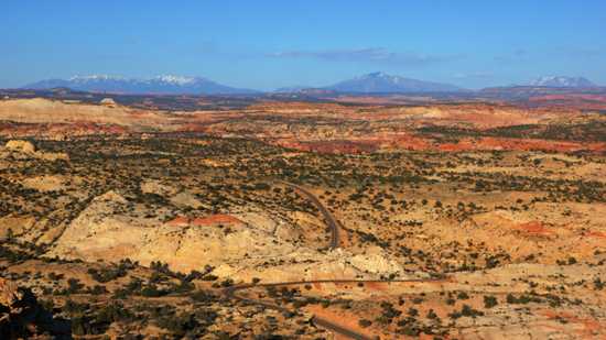
Beyond the town of Escalante, you reach the magical, other-worldly portion of U-12, shaped by the Escalante River, a tributary of the Colorado River to the southeast. The Head of the Rocks viewpoint gives you an idea of what lies ahead, as you plunge down, then twist and turn, crossing over the Escalante River, then head north.
TIP: Just beyond Escalante, you can turn off onto Hole-In-The-Rock Road, a 56-mile dead-end dirt road that comes close to Lake Powell (the dammed-up portion of the Colorado River). Early Mormon settlers used this path to reach Hole-In-The-Rock, a gap in the cliff that they blasted into a rough, vertical road. The gap provided them access to the river, and the unsettled land on the other side. If you think the landscape along U-12 is wild, you really should experience the final few miles of Hole-In-The-Rock Road.

Enjoy scenes like this one as you climb up from the river…

… to the hair-raising Hogback. This narrow section of U-12 travels along a knife-edge mountain ridge, with a drop-off on both sides, thousands of feet deep.

Beyond the Hogback, U-12 gains more elevation, until you’re nearing 10,000 feet. This part of the drive will be colder, and possibly snowier, than the rest of the road. Several viewpoints provide a look at an expansive, jumbled landscape.

I didn’t reach this great spot until after the sun had set. After you pass by here, it’s downhill to U-24, the town of Torrey, and the grand scenery surrounding Capitol Reef National Park.
I traveled U-12 on three other occasions. Back in 2004, I drove southbound, from Torrey to Cannonville (but I skipped the western end of the road, instead choosing to drive down Cottonwood Canyon Road). In 2007, I visited Red Canyon and Bryce Canyon, but I didn’t go any further east. In 2009, I started at Cannonville and drove on to Torrey. But, it wasn’t until this trip, in 2013, that I traveled the entire route, all in one trip (even though it took four days to do so).
The Bottom Line
If you’re traveling to Utah, rearrange your road trip to allow for a day, or two, or five, on U-12. This is one of the essential roads for road-trippers to enjoy. It exposes you to everything that’s great about Utah, and provides access to some of our country’s rare remaining wild areas.
Location
U-12 runs between US 89 near Panguitch (at its southwestern end) and U-24 at Torrey (at the northeastern end). If you’re starting at US 89, this end of the road is signed as east-west, and you’ll travel east for a while, before turning north near Escalante (where the road is signed north-south).
For its entire length, U-12 intersects with just one other major state road, U-22, at Bryce Canyon National Park.
U-12 passes through Red Canyon, provides access to Bryce Canyon and Kodachrome Basin, cuts through the Grand Staircase-Escalante National Monument and Dixie National Forest, and ends near the entrance to Capitol Reef National Park.
Drivelapse Video
Check out this time-lapse, dash-cam video of the entire drive up Utah Route 12, from US-89 to U-24 at Torrey. Yes, it’s a long video, but this is an extraordinary road! Captions included, to help you know what you’re seeing.


No comments