
To me, this side of the San Juan Skyway scenic loop feels like the loneliest and least-populated part of the drive. There isn’t much out here, between Telluride and Cortez, aside from excellent scenery. Be sure to check out the Drivelapse video, down the page, for a good idea of what to expect on this drive.
My Visit

Unfortunately, my goal on this day was to leave Colorado behind, and head back to New Mexico. That meant getting an early start, and leaving my hotel in Telluride shortly after sunrise.
This was the view from my room, at the Peaks Resort in Telluride Village. Who would want to leave that?
Keep in mind, if you book a room in Telluride, you could end up in the town, or in the ski village complex that’s nestled in the mountains. Even if you stay up here, you can easily take Telluride’s free gondola into town.
While The Peaks was nice, it was time to go. I headed south on Colorado Highway 145, towards Cortez.

I was just a few miles south of Telluride when I found my first excuse to stop, at a roadside turnout on Route 145. The morning sun was just beginning to brighten up the nearby peaks. Appropriately enough, I think this is Sunshine Mountain, just 64 feet shy of being a 13’er.

A few miles further south, you’ll spot an unusual-looking mountain to your northwest. That strange peak is called Lizard Head, and 13,114 feet, it is high enough to rank as a 13’er.
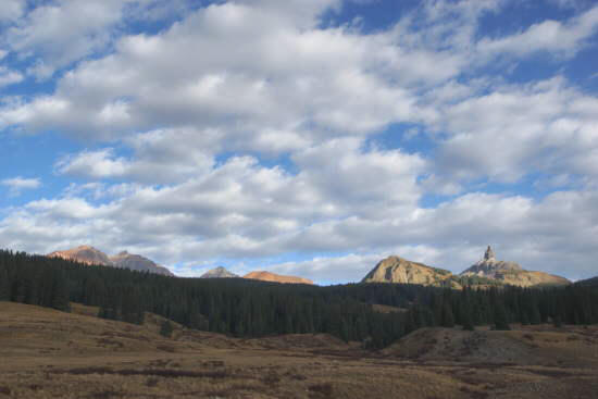
Lizard Head is just one of several peaks you can see at this roadside turnout. Mount Wilson and Gladstone Peak are both over there on the left, but all of them are partially blocked by a ridge that’s in between you and them.
Rico, Colorado

The only thing that resembles civilization along Highway 145 in this area is Rico, Colorado. A few wild-west-style storefronts line up along the main road. As you can see, the sun arrives late and sets early on this town that’s nestled between mountains.

Even though the town is tiny, it has a theatre.

If you’re just passing through, the best reason to stop in Rico will likely be this roadside exhibit that explains the town’s mining history. Mining boomed in Rico in the 1870’s, shortly after the Ute Indians gave up the land to the U.S.
Beyond Rico, you have another half-hour, at least, of a winding highway, sandwiched in between mountains, until you finally emerge into a flatter, farm-friendly landscape. The final few miles into Cortez are, without a doubt, the least interesting part of the San Juan Skyway.
The Bottom Line
This is not my favorite part of the San Juan Skyway. I’d prefer the opposite side of the loop, if I had a choice. But, if you need to get from Telluride to Cortez, this is certainly the shorter route. While it might be a bit less spectacular than some of the other parts, it will still be quite beautiful and enjoyable.
Location
The San Juan Skyway connects Durango, Silverton, Ouray, Ridgway, Telluride, and Cortez, Colorado. It makes a big 233-mile loop around and through the San Juan Mountain Range in southwestern Colorado.
This portion of the scenic byway is about 76 miles long. It connects Telluride and Cortez. Between those two points, there are only a couple of small towns.
Drivelapse Video
Check out this time-lapse, dash-cam video of the drive from Telluride’s Mountain Village area to Rico…
… and Rico to Cortez, Colorado:


No comments