
This section of US Highway 550 is part of the San Juan Skyway, an excellent loop route through the San Juan Mountains. The portion between Durango and Silverton offers a couple of high-mountain passes and great scenery, especially in Autumn, when the fall colors are on display.
My Visit
I like Durango, but I’m always happy to leave it behind. It’s a nice western town, but it always feels crowded to me, and it seems like I always get stuck in traffic. Fortunately, the congestion eases, as you leave town, headed north on US 550 — part of the San Juan Skyway scenic byway route.

I had made the drive a couple of times before (once in December, and another time in summer), but this time was much different. It was the first week in October, and Colorado’s aspen leaves were shimmering with shades of gold.

There is so much great scenery along this road, it’s almost overwhelming, especially at the peak of fall color. Truth be told, I was probably about a week too late. I suspect that in this year (2012), the height of autumn color came about a week earlier, in late September. I’m sure it varies from year to year, so if you’re planning a fall visit, you’ll need to roll the dice.

One of the most recognizable peaks along US 550 between Durango and Silverton is Engineer Mountain, a peak that’s just shy of 13,000 feet (12,968, to be exact). One of the best places to view it is this small lake, that’s located at the edge of US 550, north of the much-larger Electra Lake. You can easily park by the side of the road and walk down to it.

I stopped again, just a few hundred feet beyond that small pond. At this spot, there’s a marshy area on the left side of the road…
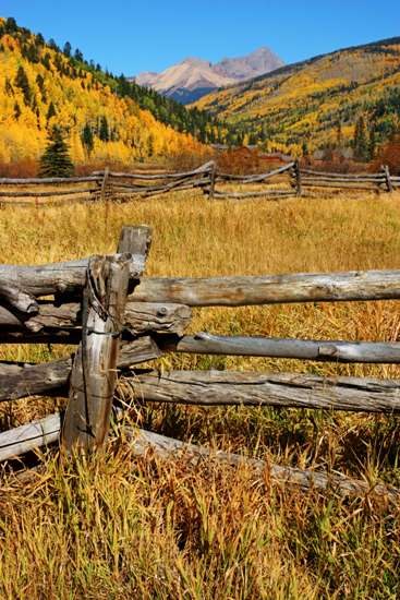
… along with an old corral. I stopped here and wandered around for quite a while, taking pictures. At this spot, the fall leaves still seemed to be nearly perfect.

Just a bit further, and you’ll reach a sweeping curve to the right in US 550. Watch for a dirt road to turn off to the left. This dirt road will take you just a couple of miles before getting very rough — but it leads into a nice, scenic area along Cascade Creek.

The highlight is this wooden flume. Most of Cascade Creek is funneled into the aqueduct, which carries the water more than 8/10 of a mile (4,400 feet). After that, the water goes into a 3-mile long steel pipe, then another creek, and into a holding pond. As it empties out of the pond, it passes through a power plant built in 1905.

While the flume serves an important function, it’s also quite beautiful, especially when winding through the colorful aspens.

Back on the main road, it’s time to make a quick climb up to Coal Bank Pass, elevation 10,640 feet. Don’t forget to bring a sticker.

The views are good, but not spectacular, at the pass. They get better as you continue north.

After Coal Bank Pass, you’ll go downhill, but not by much. You still have another pass to cross, before dropping down to Silverton.
It was obvious in this area that I had missed the peak of fall aspen color. There were still patches of leaves, barely clinging to the branches, but most of the trees were bare. I’d guess that the middle of September was most likely the best time to see the trees in this area.

US 550 makes another sweeping u-turn, on its way up to Molas Pass. Lime Creek flows through the basin below.

Just before Molas Pass, take a detour to Andrews Lake. You can park at the scenic overlook and hike down to the lake, or save the walk and park at the lake itself.

The lake might be prettier if you get here just after sunrise. By midday, the wind picks up, and the surface is choppy (although still strikingly blue).

A bit further, there’s a turnout at Molas Pass, where you can view the Rockies.

Everywhere you look, you’ll see jagged mountain peaks.
Just beyond the pass, there’s another lake — Molas Lake — which offers a similar experience as Andrews Lake.
Now it’s time to drop down towards Silverton. It’s a quick descent, as you head towards this trapped-in-time western mountain town. Watch for a very small turnout on the side of the road, at just the perfect place…

… and you’ll be able to capture a photo like this one, showing the entire town, as well as Storm Peak looming behind it.
The Bottom Line
I’ve driven this road several times, and it’s one of my favorites in Colorado. With great towns on both ends, and two mountain passes in between, how can you go wrong?
Location
San Juan Skyway connects Durango, Silverton, Ouray, Ridgway, Telluride, and Cortez, Colorado. It makes a big 233-mile loop around and through the San Juan Mountain Range in southwestern Colorado.
This portion of the scenic byway is roughly 48 miles long, and connects Durango and Silverton . It should take about an hour to drive — assuming you don’t stop to enjoy the scenery.
Drivelapse Video
Check out this time-lapse, dash-cam video of the drive from Durango to Silverton, Colorado:


No comments