
Pincher Creek may feel like a sleepy little prairie town where nothing’s happening — and that may be true. But one thing is for sure: if you’re looking to shoot some nice photos of a spectacular sunset, you have some great options.
My Visit
Fortunately, when you’re this far north, sunset comes slowly. I had spent a good chunk of my afternoon and evening driving around the prairie and foothills of southern Alberta, in the area south of Pincher Creek, north of Waterton Lakes, and west of Route 6. As sunset approached — around 9:30 p.m. at the end of June — I was finally making a serious effort to get to Pincher Creek, and wondering where I would take my final photos of the day.
And then I remembered the railroad tracks, on the north side of Route 3. I had been here before, in March, 2012, when snow was still piled up on the ground, and the skies were grey. This night was much different.

I parked the car and started running around like a crazy person. There are several grain elevators here, some newer than others, but this one seemed to be the most picturesque. The rail cars on the tracks nearby hadn’t budged since that cold day in 2012 when I trudged through the snow to photograph them.

I took a few steps back to the railroad crossing at the road. It’s quite helpful that the sun sets slower at this latitude.
Highway 6 officially ends at the intersection with the Crowsnest Highway, but if you continue north, you pass the rail yard, and then you go uphill. The road turns to dirt, but it’s an easy drive into the hills that hold Pincher Creek’s massive power-generating wind farm.
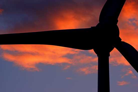
This is a fun place to take photos of these captivating machines. And it’s even better at sunset.

There’s a great view, looking towards the west. Those mountains are lined up along the Continental Divide. Just about 60 kilometers away, Highway 3 crosses over Crowsnest Pass and into British Columbia.

As much as I wanted to continue photographing the area, I also wanted food. At this point, it was about 9:45 p.m., and I hadn’t had dinner, and I needed something for breakfast. I hurried back to the Walmart that’s just south of Highway 3, only to discover that it closes at 10 o’clock. I grabbed a few items quickly, and checked out.
As I mentioned, this area looked a lot different when there is snow on the ground:

That’s the same grain elevator, in March 2012…

… and a few of the turbines that make up the massive wind farm.

If you have a chance, it’s also worth your time to drive through downtown Pincher Creek. Or, you can read about my 2012 visit to the town here.
The Bottom Line
There are plenty of good opportunities to catch a nice sunset around Pincher Creek, especially if you head to the rail yard and wind farm north of town. The town itself lacks excitement, but it offers plenty of hotels, so you can make it your base of operations for a visit to Waterton Lakes or other attractions in Southern Alberta.
Location
Pincher Creek is located in southern Alberta, about 215 kilometers south of Calgary. The town is located near the intersection of Alberta Route 3 — the Crowsnest Highway — and Route 6.
The town itself is located just a few kilometers south of Highway 3, but the town’s rail yard, grain elevators, and wind farm are located just to the north of that intersection. This is the area where I focused my efforts at sunset.

Drivelapse Video
Check out this time-lapse, dash-cam video of the drive from Waterton Lakes National Park to Pincher Creek, Alberta (a very indirect route)…
… and Pincher Creek back to Waterton:


No comments