
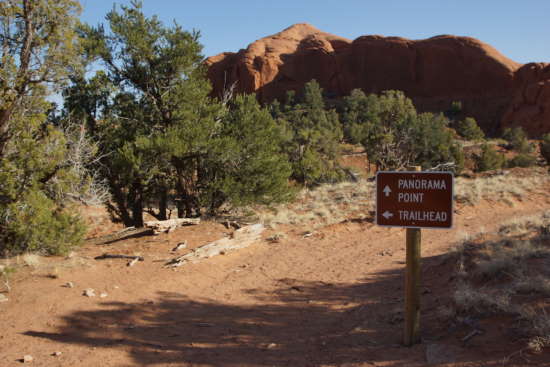
The Panorama Trail is a great way to spend an hour, or several hours in Kodachrome Basin State Park. The loop trail has several shortcuts and side routes, allowing you to make it as short or long as you want. Along the way, you’ll pass numerous spires and rock formations.
My Visit
I arrived in Kodachrome Basin State Park with just a few hours of daylight remaining in the day. Since I was spending the night in one of the park’s cabins, I didn’t have to worry about getting back to civilization before dark, so I had the luxury of devoting the remainder of the day to just one trail — one that offered plenty of options.

The Panorama Trail is a loop trail, although at the very beginning and end you’ll be on the same path. The trail is never extremely steep or challenging, it’s just a nice, long walk through the desert, giving you an up-close look at much of Kodachrome Basin’s fascinating geology.

The trail begins near the cabins, and heads west, circling around a cliff and dipping a time or two into dry washes. Before long, you’ll turn north, and begin a counter-clockwise trek around an expansive basin, that’s littered with fun things to see.

The first named attraction is Ballerina Spire, one of 67 sand pipes in the park. These spires were once geysers, which filled up with sediment and solidified over time. Then, the surrounding sandstone eroded away, exposing the concrete-looking chimneys of rock.

The next stop on the loop is the “Hat Shop”. I suppose there were a few formations here that looked like hats, but you couldn’t easily get up-close to any of them, so I moved on.

The trail splits at Secret Passage, with a loop that leads through this interesting area. I wasn’t always sure I was on the right path, but it would be tough to get lost for long here.

The Secret Passage portion of the trail squeezes through some spots, and doesn’t appear to be as well-worn as the main trail, but eventually it leads here, to this amphitheater in the side of the cliff.

It was tough to photograph because of the sun, but take my word for it, it’s a neat spot that requires a short climb, to get to a great viewpoint of the valley.

Nearby, you’ll spot these cone-shaped hills…

… which are apparently capped by some slightly more solid rock, allowing erosion to form tee-pee-like structures.

There are several of these, but late in the day, the shadows were already making photography difficult. You might get better pictures here, in mid-afternoon or early in the morning.

Back on the main trail, it’s just a short distance before you reach the Mammoth Spire Overlook. It’s out there, in the distance, and poorly lit in the evening.
Also in this area, there’s a turnoff to the Cool Cave trail, which would add another two miles to the hike. I wouldn’t have minded the extra exercise, but I figured it was too late in the day to tack on another destination.
You could also take a shorter loop, back towards Ballerina Spire. I figured I had enough time to keep going towards the southwestern side of the loop, and Panorama Point.
The trail to Panorama Point splits away from the loop, and requires the most exertion of any part of the hike. You’ll gain elevation quickly…

… but along the way, you’ll have a nice view of this sandstone hill…

… and you’ll skirt the edge of that big rock…

… on your way up to this spot. Turn around…
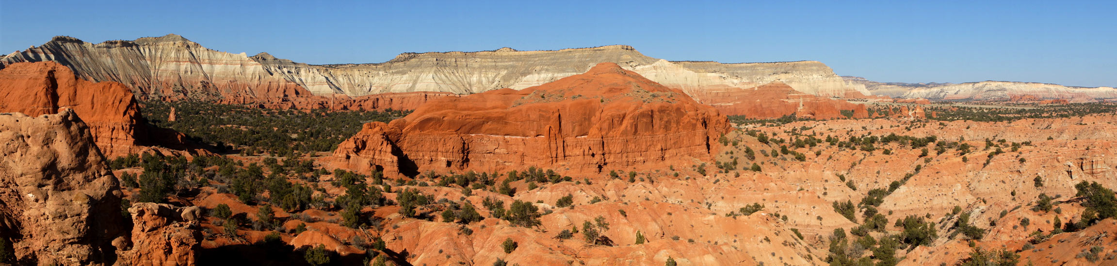
Click here for a larger version of this photo
… and you’re treated to this sweeping panorama of Kodachrome Basin. You’ll be able to see the entire area, through which you just hiked. The park entrance is over on the right, and you should be able to spot the park road and the familiar spire near the park entrance.
And then you realize just how far you’ll need to walk, to get back to where you started. Yes, it is waaaay over there.
Before you leave Panorama Point, you might want to try using your cell phone. I had a spotty signal here, but with the wind, it was tough to carry on a conversation. Later, I had to drive back to Escalante and several miles beyond, before I could find another spot with cell-phone coverage.
Hike back down the hill, rejoin the main trail, then head east. There isn’t as much to see on this part of the trail, which is probably why the park encourages you to take it counter-clockwise. You’ll go down several dips, once again, into dry washes, then back up again.

Before long, the entrance to the park, and its easily recognizable spire, is in view.
I don’t know exactly how long the trail is. I’ve read that it’s 2.9 miles, or 3.1, and I suspect those distances don’t include the various side trips you’ll probably make to places like Panorama Point. The sign at the trailhead says 6 miles, but that might include the trek out to Cool Cave. All I know for sure is that I hiked it in a little over two hours, keeping up a fairly rapid pace (but stopping frequently for photos).
The Bottom Line
This is certainly one of Kodachrome Basin’s best hikes. While it could be a bit lengthy for some people, it’s not especially challenging, thanks to the relatively flat ground you’ll cover. And, it provides up-close access to numerous spires and other features. Try to reserve 3-4 hours, and take it all in, at a slow pace.
Location
Kodachrome Basin State Park is located south of Cannonville, Utah, on Cottonwood Canyon Road. Follow the paved road into the middle of the park, and watch for the Panorama trailhead on your left, roughly across the street from the cabins and store.
Drivelapse Video
Check out this time-lapse, dash-cam video of the drive up Cottonwood Canyon Road, then into Kodachrome Basin State Park:


No comments