
187,000 acres of the Oregon Outback are protected as part of the Malheur National Wildlife Refuge. These wetlands south of Burns, Oregon are an excellent place for bird-watching, or just enjoying the desert scenery.
My Visit
As soon as you leave Burns, Oregon, Route 205 provides a beautiful drive through wide-open ranchland.

I stopped to admire some small manmade hills of hay, at the side of the road.

Route 205 is straight as an arrow for the first few miles as it heads south. Then, you climb a small hill, and drop down the other side, and after a few more miles, you arrive at Malheur Lake. Route 205 squeezes between the ponds, then continues south.
Just beyond the narrows, you could turn east on Sodhouse Lane, to check out the historic Sod House Ranch. Buildings at the ranch were built in the 1880’s, when the ranch served as the northern headquarters for ranch owner Peter French (his name is also on the famous Round Barn, east of here). I skipped Sodhouse Lane for now, since I planned to make a counter-clockwise loop and return here later.
What I should have done was turn on Sodhouse Lane, then turn south on Center Patrol Road. It’s a dirt road that provides excellent wildlife-watching access to the wetlands in the middle of the preserve. I didn’t discover Center Patrol Road until after I visited…
Buena Vista Overlook

As I drove through Malheur, my first stop was at Buena Vista Overlook. It’s a small hill on the east side of Route 205. A side road takes you to the top, where a viewpoint looks out on the Buena Vista Ponds. It’s a great spot to take in the surrounding landscape, with views as far as Steens Mountain to the southeast.
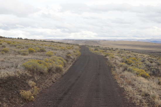
Center Patrol Road

At Buena Vista, I picked up a guide pamphlet that directed me onto Center Patrol Road. I only traveled a short distance on this road, headed south to Diamond Lane, but as you can see, it’s a beautiful drive. I didn’t observe a lot of wildlife, but I was in a hurry to cover ground, rather than take it slow, so I probably missed some of the local creatures. This list from the FWC tells you which birds you’re likely to see during each season.
When I reached Diamond Road, I turned east towards the town of Diamond, then took a brief detour into…
Diamond Craters Outstanding Natural Area
Part of the loop in the Diamond Loop Scenic Tour Route passes through the Diamond Craters Outstanding Natural Area. It’s a landscape that would be very exciting to a geologist, but to the casual visitor, I’m not sure it will live up to the “outstanding” moniker.
I turned off on a small dirt road that leads into the middle of Diamond Craters ONA. The road passes several basaltic volcanic features. These craters were formed between 6,000 and 60,000 years ago. You’ll find lava tubes, lava flows, cinder cones, and maars (a broad volcanic crater formed when groundwater comes in contact with magma). The area is purported to have the best and most diverse basaltic volcanic features in the U.S., all within a relatively small area.

Like I said, it’s fascinating to a geologist, but for me, I just looked over the area, said “that’s nice” and moved on.
Since the town of Diamond and the Peter French Round Barn are somewhat of a detour away from the wildlife refuge, I’ll cover them on a separate page.
Narrows-Princeton Road, a.k.a. Sodhouse Lane

By the end of the day, after looping around through the town of Diamond, Happy Valley, and the Peter French Round Barn, I ended up on Narrows-Princeton Road — an east-west dirt road that passes south of Malheur Lake. (It’s the western end of Sodhouse Lane, which I mentioned earlier). I didn’t make it to the lake before dark, but I did get to enjoy a beautiful sunset.

Narrows-Princeton Road runs alongside a long line of utility poles until it reaches the lake, then it curves around the southern edge of the water. I took a few pictures, then drove back to Route 205, and then back to my motel in Burns, after dark.
In case you’re wondering, I stayed at the Horseshoe Inn on US 20/395, on the northeast side of town. It was the cheapest room of my trip (under $50), but also one of the nicest, with a clean, remodeled room.
The Bottom Line
The Malheur National Wildlife Refuge is well worth your time. Take Center Patrol Road the entire way, if you can. Bring your binoculars, and stop frequently for some bird-watching. If you have time, drive over to Diamond. Definitely visit the Round Barn. You can skip Diamond Craters ONA if you’re short on time, and you’re not fascinated with geology.
Location
Malheur National Wildlife Refuge is located south of Burns, Oregon on Oregon Highway 205. The refuge measures 39 miles wide and 40 miles long, stretching from Malheur Lake all the way to Frenchglen, Oregon.
Drivelapse Video
Check out this time-lapse, dash-cam video of the drive south from Burns, through the refuge, and on to Diamond:


No comments